Cold weather goes on and on and on. And now it is looking likely that the first accumulating snow of the season for most of New Jersey is coming this weekend. Friday will be a continuation of Thursday, bright but blustery. 20s in the morning (with a biting wind chill in the teens). Only mid 30s in the afternoon. Saturday warms to around 40 degrees, with quiet weather during the day. And then a fast-moving batch of light to moderate snow will spread statewide from late Saturday evening through Sunday morning. Up to a few inches of snow fluffy accumulation could result in some travel difficulties for those up and about early Sunday. Alongside the statewide blast of wintry weather, it will get even colder — temperatures will be stuck below freezing from Saturday night through the middle of next week.
Friday & Saturday: Just plain cold
We will talk a lot about snow in this article. But let’s not lose sight of the other big weather headline here — it’s cold out there! For many NJ weather stations, this ranks among the top five or top ten coldest starts to December on record. And believe it or not, it is going to get even colder soon.
Friday morning’s temperatures are mainly in the 20s across New Jersey. But we have a biting breeze, occasionally gusting over 20 mph. That is pushing the dreaded wind chill (the “feels like” or “apparent” temperature) into the teens in many spots. It is another “bundle up” day for sure.
High temperatures Friday afternoon will only reach the mid 30s, despite mostly sunny skies. The air will remain very dry. And our weather looks dry too, although in this environment a stray flurry or quick snow shower is realistically possible at any time.
Clouds will increase Friday night, with lows again in the mid 20s. And then Saturday inches closer to 40 degrees under mostly cloudy skies. The daytime hours will be quiet — no wintry weather yet.
Weekend snow chance: Timing
While an isolated snow shower may develop right around sunset Saturday, the best chance for wintry weather will hold off until the late evening hours.
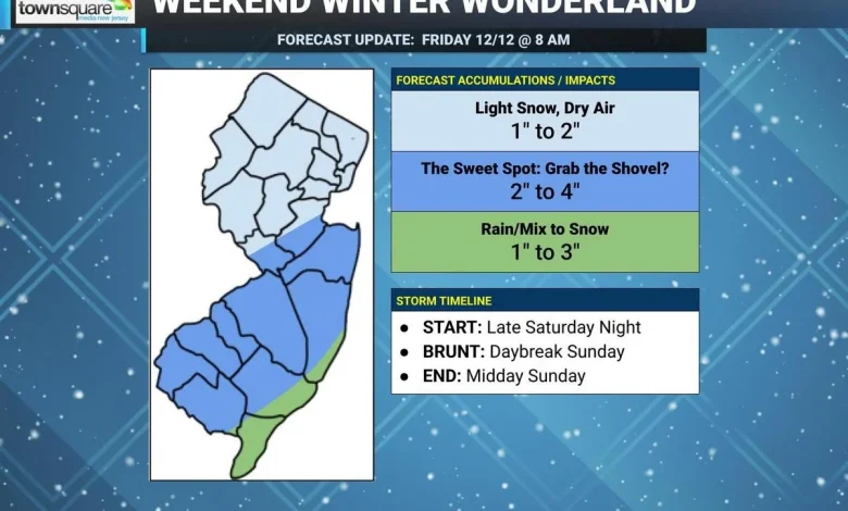
In fact, the overall window for accumulating snow looks to be from about 10 p.m. Saturday to 10 a.m. Sunday. That means you might be waking up to some tricky travel conditions Sunday morning, with light to moderate snow falling across most of New Jersey at that time. (We can call daybreak Sunday the “brunt” of the storm, with the steadiest, most widespread snow of the event.)
As snow tapers off by midday Sunday, skies will partially clear into the afternoon. But temperatures will be quite cold. Highs on Sunday will only reach about 30 degrees, with a brisk wind. Blowing snow and biting wind chills and going to make for quite the wintry end to the weekend.
Weekend snow chance: Accumulations
In figuring out how much snow will both fall from the sky and accumulate on the ground, there are several factors we have to consider here:
—The storm track, and specifically where the axis of heaviest snow will pass
—Temperatures, which will definitely be cold enough to sustain “all snow” except along the immediate coast
—Cold temperatures also lend toward a higher snow ratio, leading to a fluffier, drier snow that accumulates faster than heavy, wet snow
—Dry air, which could limit snow intensity in northern New Jersey especially
—The storm system will be moving fairly quickly, only lasting a few hours in any location
—For many parts of New Jersey, this will be the first accumulating snow of the season, which adds to the potential “hype factor” of the storm
—The mid-weekend timing complicates the communication of this forecast
Taking all that into account and the latest model guidance, I have settled on the following accumulation forecast:
—2 to 4 inches for inland central and southern New Jersey, the “sweet spot” most likely to see shovelable snow by Sunday morning
—A bit less, on the order of 1 to 3 inches, along the immediate coast as rain may initially mix with snow at onset
—Quite a bit less, around 1 to 2 inches, for northern New Jersey, which falls under lighter snow and drier air
Latest forecast for this weekend’s snow, as of Friday morning. (Dan Zarrow, Townsquare Media)Latest forecast for this weekend’s snow, as of Friday morning. (Dan Zarrow, Townsquare Media)
Weekend snow chance: Impacts
Note: No official alert products have been issued by the National Weather Service yet for this weekend’s snow, because it is too early. This is clearly an “advisory” level event, which will not come out until about 24 hours before arrival.
There will be some travel issues Sunday morning due to slippery roads and reduced visibility (due to both falling and blowing snow).
Snow should be very easy to clear, given how powdery it is. A leafblower may be a better option than a shovel or snowblower for this one.
Whatever snow falls by Sunday morning will stick around for a while, as temperatures stay frigid. New Jersey will remain below freezing through the day Sunday and Monday and possibly Tuesday too.
Weekend snow chance: Confidence
Honestly, this is a fairly straightforward winter storm forecast. There is good model agreement. And the cold air making for an almost all snow scenario makes matters much easier too.
There are two areas I will be watching for potential forecast refinements:
1.) Reducing North Jersey snow totals even farther, to a half-inch or even a coating, if they really fall out of the main snow bands.
2.) There is a chance for overperformance in the sweet spot too, especially if temperatures are even colder and the snow is even fluffier than expected. If snow ratios come close to 20:1, we might have to think about localized totals of 5″ or 6″ somewhere.
With 36 hours to go until first snowflakes, we have plenty of time to ponder these details and make adjustments if needed. It is important to stay tuned for the latest forecast updates throughout the weekend.
Looking ahead at next week
As frigid air grips New Jersey, Monday morning lows will be in the teens and highs are forecast to only reach the upper 20s. With snow on the ground, that is going to be quite the wintry day.
Tuesday will be slightly better, with highs near the freezing mark.
And then the warming trend should continue, with 40s on Wednesday and 50s on Thursday. Yes, finally a welcome warmup as we pass the midpoint of December. In fact, long-range model guidance shows more mild temperatures than not through the second half of the month as we approach the holidays. While that is not a guarantee — and it is not a guarantee that we will not see any more snow on the horizon — that would be a welcome sign after so many cold weeks to close out autumn.
5 DAY FORECAST: New Jersey Weather Center
First flakes: When does snow season start in NJ?
Gallery Credit: Dan Zarrow
Dan Zarrow is Chief Meteorologist for Townsquare Media New Jersey. Follow him on Facebook for the latest forecast and realtime weather updates.
Cough, cough: NJ’s favorite lost voice and sore throat remedies
Gallery Credit: Dan Zarrow