As the community of Tuktoyaktuk braces for a weekend of blizzard conditions predicted to begin this morning, more communities in the Aklavik, Inuvik and Paulatuk region are facing extreme weather and warnings.
Originally Environment Canada had predicted that a blizzard would begin late Friday in Tuktoyaktuk, but according to reports, conditions intensified earlier than expected and the storm is predicted to begin this morning.
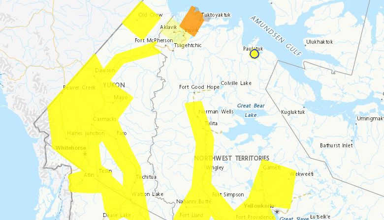
An “orange warning” is in effect currently in the Tuktoyaktuk region and a storm surge warning.
Environment Canada transitioned to a new colour-coded system for weather alerts last month. Under the new system, yellow alerts are issued when there is potential for moderate damage or health impacts, orange alerts are for more severe conditions and red alerts warn of potentially extreme and life-threatening weather.
“Blizzard conditions with poor visibility in snow and blowing snow are likely beginning this morning.This may be a major storm,” says Environment Canada.
“Snow and blowing snow will begin this morning. Visibilities will deteriorate to near zero as the winds shift to be from the west and increase in strength. Wind gusts up to 80 km/h are possible”
The extreme weather is predicted to continue into the weekend, and some meteorologists have warned it could last longer.
Environment Canada is also cautioning travellers to avoid the area.
“Travel will be dangerous and likely impossible due to near-zero visibility.”
The Aklavik and Inuvik regions are facing “yellow watches” warning of winter storm conditions
“Reduced visibilities in snow and blowing snow are possible tonight,” said the weather agency.
The storm is expected to begin tonight and conditions are expected to continue into the weekend.
“Strong northwest winds will develop tonight, with gusts up to 80 km/h possible. This combined with freshly fallen snow may generate widespread reduced visibilities in blowing snow.”
Environment Canada and NWT Alert is warning that “visibility may be suddenly reduced to near zero at times.”
A “yellow” blizzard warning is in effect for Paulatuk
“Winds from the south will continue to strengthen, gusting as high as 90 km/h. These strong winds combined with falling snow will reduce visibilities to near zero as the snow blows around,” warns Environment Canada.
Forecasters said that the blizzard conditions “will gradually improve” by tonight but reduced visibilities in blowing snow may continue into Saturday.
Environment Canada warns that travel will be “hazardous” because of near-zero visibility.
Paulatuk is also under a yellow wind warning.
Environment Canada predicts that strong winds will continue today.
“Winds from the south will strengthen, gusting as high as 90 km/h.”
Forecasters say the winds will likely weaken tonight.
Environment Canada issues wind warnings when there is a significant risk of damaging winds.
Environment Canada has issued a yellow cold warning, with wind chills of minus 50 expected for the regions of North Slave region, Hay River, Fort Providence region, Fort Liard, Norman Wells and Tulita.