Last week’s heavy rains and flooding have wreaked havoc on most of the state’s mountain passes, especially U.S. Highway 2 (US-2) over Stevens Pass.
After a pair of closures impacted Stevens in two separate locations due to issues like standing water and mudslides during the middle of the week, a 49-mile stretch of the highway from Skykomish (mile marker 50) to the west edge of Leavenworth (mile marker 99) was subsequently shut down and remains closed as of Monday morning because of similar concerns, as well as extensive damage to the roadway in several places, including the Tumwater Canyon area.
Altough the Washington State Department of Transportation (DOT) is still officially in the process of assessing all of the damages, photos posted to its social media accounts late Friday and Saturday depict scenes of destruction that are likely to take months to fully repair.
However, DOT spokesperson Lauren Loebsack tells NewsRadio 560 KPQ that it’s possible the damages could at least be temporarily resolved in a much shorter timeframe.
“There might be some things we can do to get into those areas and repair the damage before winter,” explains Loebsack. “Whether that means that all lanes of the roadway could re-open, we’re still in the process of assessing that. So we are looking at months in the sense that it will take that long for us to get everything done so it can go back to the way things were prior to the damages, but as far as months of closure time are concerned, I actually doubt that at this point – even in the worst areas.”
Loebsack says there are numerous locations within the current closure zone on US-2 where heavy damage has occurred, including three in particular.
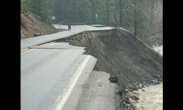
A giant cavity fills the eastbound lanes of U.S. Highway 2 at milepost 97 through Tumwater Canyon where the swollen Wenatchee River carved into the primary artery that links Leavenworth with the state’s westside. photo credit: Washington State DOT
A giant cavity fills the eastbound lanes of U.S. Highway 2 at milepost 97 through Tumwater Canyon where the swollen Wenatchee River carved into the primary artery that links Leavenworth with the state’s westside. photo credit: Washington State DOT
The most visibly impacted portion of the road is in Tumwater Canyon at milepost 97 about eight miles west of Leavenworth, where a large chunk of the roadway became entirely dislodged and collapsed into the raging waters of the Wenatchee River.
Other trouble spots include milepost 72 near the Stevens Pass summit, where there are several miles of the road which have been completely eroded, and at milepost 54 just east of Skykomish, where the road has sustained heavy damage due to being continuously inundated with standing water.
Other images posted by the DOT show cracked and crumbling asphalt along the shoulder of the roadway, displaced sections guardrail that also appear to have fallen into the Wenatchee River in the Tumwater area, and deep swathes of mud and debris covering the highway.
Large sections of pavement buckle and crumble along the shoulder of U.S. Highway 2 near Leavenworth – photo credit: Washington State DOT
Large sections of pavement buckle and crumble along the shoulder of U.S. Highway 2 near Leavenworth – photo credit: Washington State DOT
Amidst the road’s ruination and the lengthy closure, the City of Leavenworth looked eerily empty over the weekend, after its highly-popular Village of Lights celebration was cancelled due to issues caused by the storm.
In addition to the possibility of the festival’s continued shutdown this weekend due to another storm that’s expected to impact the region through Thursday, many business owners in the Bavarian Village are greatly concerned about the economic impacts that a protracted closure of US-2 could bring to the town, whose economy is driven entirely by tourism.
Although the DOT has yet to issue any specific details regarding the issues affecting US-2 and Tumwater Canyon, Loebsack says it is like a detour might soon be established using State Route 207 and the Chumstick Highway from Coles Corner to Leavenworth’s east side that will once again allow traffic to flow more directly into the tourist mecca.
Until such a route is established, however, Leavenworth only remains accessible from the west side of the state via a combination of Interstate-90 over Snoqualmie Pass and U.S. Highway 97 over Blewett Pass, or other combined routes with even longer travel times.
Loebsack adds that public safety is also of prime concern to the DOT at this time, especially since there have already been several reports of motorists venturing into the closure zone.
“I’ve seen some videos on social media of people who are getting up close to the pavement is eroding near the raging river, and I just can’t be more serious when I say that people absolutely should not be doing that and need to stay out of the areas we have closed. It’s not safe in there and that’s why even we (DOT) aren’t in there right now. It’s especially dangerous right now because if something terrible should happen to a person who chooses to go beyond the barricades, our crews and the region’s first responders are already stretched thin and they’re going to then be in harm’s way when they are able to get in there and try and do a rescue.”
Loebsack says the road has been undermined in many areas and, at least in the Tumwater Canyon, more chunks could easily break off, presenting enormous peril for anyone who might be in a location where this happens.
The DOT also has mounting concerns about the new storm system which is already deluging the region with rain and could drop as much as 12 inches of liquid precipitation by the end of the week, along with up to three feet of snow in the mountains above 2,000 feet. Loebsack cautions that the agency will likely need to wait for this week’s storm to pass through the region before it is able to tackle some of the damaged sections of US-2 because additional damages could easily occur, which will also require full assessments and repair plans.