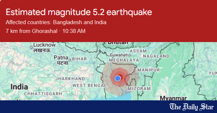
Tropical Storm Melissa Forecast To Become Major Hurricane

Melissa Expected To Be Major Hurricane
Tropical Storm Melissa is forecast to become a major hurricane by early next week, prompting new watches and warnings. But its slow crawl over the Caribbean Sea makes it a rainfall flood danger and will bring days of tropical storm or hurricane conditions for parts of Haiti, Jamaica and Cuba.
A grueling couple of days are ahead for Jamaica. Many hours of heavy rain and dangerous winds are increasingly likely.
(MORE MAPS: Melissa Map Tracker)
Where It Is Now
Melissa’s center is located in the central Caribbean Sea, several hundred miles south of Haiti and Jamaica. And it is still crawling forward at just 2 mph.
Some outer bands of showers and thundershowers are streaming northward across parts of Jamaica, Hispaniola and Puerto Rico with soaking rainfall and gusty winds.
Current Satellite Image
(The highest cloud tops, corresponding to the most vigorous convection, are shown in the dark red and pink colors. Clustering, deep convection around the center is a sign of a healthy tropical system.
)
Forecast Track
While there were originally a couple of more likely scenarios that could play out for Melissa’s track, forecast models have narrowed down to just one forecast track near or over Jamaica. However, there remains an outside shot that Melissa could alter from this:
- Sluggish movement into next week, then a delayed northeastward curl: It is increasingly likely that Melissa moves sluggishly north, then west over the western Caribbean Sea through early next week. This track will take the storm near Jamaica on Sunday, Monday AND Tuesday before it finally accelerates northeastward toward Cuba and the Bahamas by the middle of next week.
This may be a long, drawn-out affair lasting well into next week.
For now, the threat to the mainland U.S. from Melissa — primarily to South Florida — appears to be very low, but not zero.
Current Status, Forecast Path
(The red-shaded area denotes the potential path of the center of the tropical cyclone. It’s important to note that impacts (particularly heavy rain, high surf, coastal flooding, winds) with any tropical cyclone usually spread beyond its forecast path.
)
Days of Heavy Rainfall
The outer rain bands of Melissa are foreshadowing of a particularly dangerous situation that is unfolding for parts of the Caribbean.
The situation is becoming especially concerning for Jamaica, as the center of the storm is expected to linger around the nation for days.
Melissa’s slow speed means heavy rainfall will last for several days. Parts of the Dominican Republic, Haiti and Jamaica could pick up over 14 inches of additional rainfall through next week. Isolated totals over 14 inches are not out of the question and are becoming more likely.
Some bands or clusters of locally heavy rain are also likely in Puerto Rico, the Virgin Islands, the Turks and Caicos, Cuba and parts of the Bahamas.
That heavy rainfall is likely to trigger life-threatening flash flooding and landslides in hilly and mountainous terrain.
(MORE: Why Slow-Moving Storms Are The Worst)
Additional Rain Forecast
(This should be interpreted as a broad forecast of where the heaviest rain may fall and may shift based on the forecast path of the tropical cyclone. Higher amounts may occur where bands of rain stall over a period of a few hours. )
Wind Alerts
The map below shows the latest watches and warnings in effect for Melissa.
A hurricane watch means hurricane-force winds are possible, and tropical-storm-force winds could move in within 48 hours.
A tropical storm warning means tropical storm conditions are expected within the next 36 hours. These winds could persist for days once they start.
These alerts currently cover parts of southern Haiti and Jamaica.
Watches And Warnings
(A watch is issued when tropical storm or hurricane conditions are possible within 48 hours. A warning is issued when those conditions are expected within 36 hours.
)
How Strong?
For the next few days, wind shear may keep Melissa from intensifying quickly. This difference in wind speed and/or direction with height can blow thunderstorms away from the center or tilt the circulation.
Wind Shear
(Areas of strong wind shear, the difference in wind speed and direction with height, are shown in purple. High wind shear is hostile to mature tropical cyclones and those trying to develop.)
But by this weekend, that wind shear is expected to relax.
And Melissa will be over the most abundant supply of warm, deep water anywhere in the Atlantic Basin, serving as fuel for strengthening.
Therefore, we expect Melissa to rapidly intensify into a major (Category 3 or stronger) hurricane either by this weekend or early next week as its center is near Jamaica.
Land interaction with Jamaica and Cuba could limit the storm’s intensity at some times.
(MORE: Rapid Intensification Is More Common Than You Think)
Ocean Heat Content
(This map shows areas of not only warm water, but warm, deep water that is one ingredient to fuel developing and active tropical cyclones.
)
Wind Threat
According to the National Hurricane Center, hurricane conditions are possible in Haiti and Jamaica beginning Friday afternoon.
Tropical storm conditions are expected to move into Jamaica early Friday.
Hurricane Wind Chances
(The contours above show the chance of hurricane-force winds (at least 74 mph), according to the latest forecast by the National Hurricane Center.
)
Number 13
Tropical Storm Melissa formed late Tuesday morning, the 13th storm of the 2025 Atlantic hurricane season.
That’s roughly on par with the average date of the 13th storm from 1991 through 2020 (Oct. 25), according to the National Hurricane Center. It’s also one storm shy of the average number of storms for an entire season, 14.
The 2025 Atlantic hurricane season names list. Those storm names used up already have check marks next to them.
Melissa is also the first storm of the season to track into the Caribbean Sea. As you can see in the season-to-date tracks map below, most other storms and hurricanes have curled north of the Caribbean Sea this season.
That’s due either to steering winds in the Atlantic, or hostile conditions for development in the Caribbean Sea prior to Melissa.
2025 Atlantic Hurricane Season Tracks To Date
Check back with us at weather.com for the latest forecast updates on Melissa, and elsewhere in the tropics.
Jonathan Erdman is a senior meteorologist at weather.com and has been covering national and international weather since 1996. Extreme and bizarre weather are his favorite topics. Reach out to him on Bluesky, X (formerly Twitter) and Facebook.


