Millions of residents in South East Queensland and parts of NSW are in the firing line for a supercell storm, which is expected to bring a deluge of rain, giant hail and a possible tornado.
The Bureau of Meteorology issued a severe thunderstorm warning for residents south of St Lawrence, striking between Rockhampton and Gympie on Friday afternoon, driven by an unstable air mass.
A severe warning has also been issued for residents in central and northeast NSW, with giant hail, damaging winds and rain forecast to smash areas north of Armidale on Saturday.
Senior meteorologist Kimber Wong told NewsWire the “potent” storm could be extremely intense and destructive, with a risk of large to giant hail – roughly the size of a $2 coin.
“Severe storms may bring the risk of locally damaging wind gusts in excess of 90km/h, which is sort of strong enough to bring down trees and powerlines and the like,” she said.
There is also a risk of heavy rainfall, which may result in life-threatening flash flooding.
Ms Wong warned the destructive weather may be worse than a typical thunderstorm.
“Severe thunderstorms are occurring (on Saturday), and potentially some very dangerous thunderstorms, (with) more dangerous elements to them such as destructive wind gusts and potentially giant hail with stones in excess of 5cm diameter,” she said.
“(Saturday) is very ripe set up for that type of storm activity to happen.”
She said there was also a risk of a supercell storm developing in South East and Central Queensland over the weekend, potentially bringing a tornado with it.
“If any tornadoes do occur, it will probably be quite short-lived and very, very localised in impacted areas,” she said.
“But not totally out of the question.”
While the storms are potentially more destructive than normal, wild weather is nothing out of the ordinary for South East Queensland.
“We’re at the end of October – it’s peak storm season, so it’s not totally uncommon to see storms this time of year,” she said.
“As we’ve seen in recent storm outbreaks within the past couple of weeks, storms this type of year can really pack quite a punch.”
The destructive storm comes a day after a young woman diedafter being struck by lightning on the Sunshine Coast, with more wild and dangerous weather expected to smash millions this weekend.
The woman was struck by lightning at a sporting complex in Cooroy about 5.30pm on Thursday.
Paramedics treated the 21-year-old woman at the scene, rushing her to Nambour Hospital, where she later died.
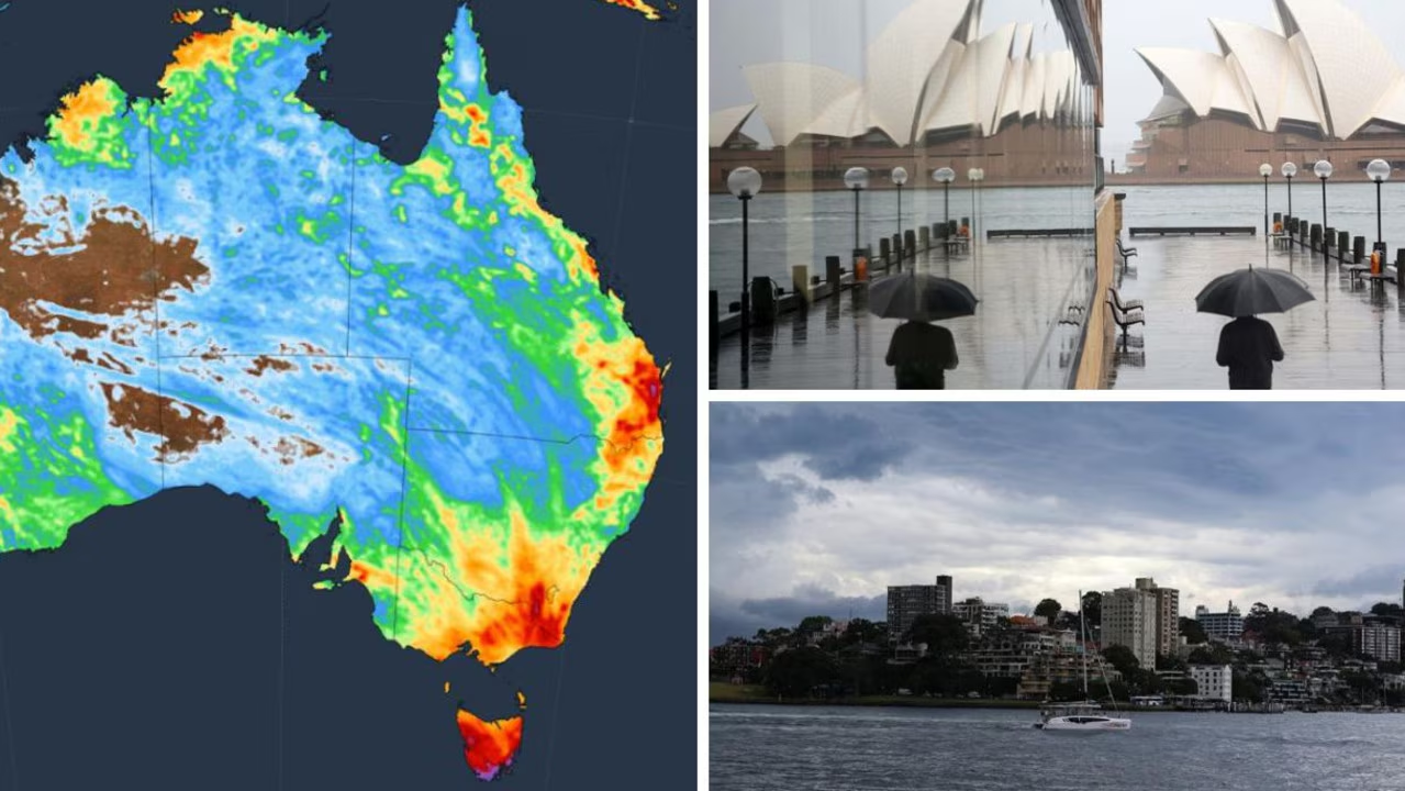
Wild weather conditions will continue this weekend, as a band of rain, storms and potentially giant hailstones smashes the east coast.
Bureau of Meteorology senior meteorologist Jonathan Howe said the intense storms would ramp up on Friday before peaking over the weekend.
“Brisbane (on Friday) could see severe thunderstorms – more likely tomorrow than today, and they could bring again large hail and damaging winds,” he said.
“Saturday looks to be the peak of thunderstorm days, particularly across South East Queensland.”
Areas impacted include Wide Bay, Gold Coast and Greater Brisbane areas, with the threat stretching as far as Townsville, Mackay, Gladstone, and Rockhampton.
NSW residents won’t be immune to the powerful storms, with parts of western Sydney in the firing line for rain and thunderstorms.
The most intense storms are forecast to form over eastern parts of NSW and Queensland on Saturday, according to Weatherzone, with the risk of a supercell thunderstorm and possibly an isolated tornado in some areas.
The gloomy conditions are also spreading through the country’s south, with showers forecast to pass over South Australia and towards Victoria on Friday, bringing a possible thunderstorm along the way.
While the conditions will dry out over the weekend, Melbourne residents are set for another soaking on Monday and Tuesday.
“Monday’s looking pretty soggy across Melbourne,” Mr Howe said.
“We will probably see some showers across the city on (Melbourne) Cup Day itself, so it could be pretty soggy for punters at Flemington, but hopefully it won’t be too wet.”
Brisbane residents can expect a partly cloudy day with a medium chance of showers and a thunderstorm in the afternoon, reaching a top of 28C.
It will be a wet and soggy day in Sydney, with showers forecast in the afternoon and a top of 25C.
Conditions will be similar in Canberra, with cloudy skies and a high chance of showers, with a maximum temperature of 24C.
Melbourne residents can expect an overcast and cloudy day, with a high chance of showers and thunderstorm in the afternoon and a top of 22C.
It will be partly cloudy in Hobart, with a medium chance of showers and the mercury reaching 21C.
There is a chance of a thunderstorm in Adelaide on Friday, followed by showers and a maximum temperature of 24C.
Conditions will be partly cloudy in Perth, with a high chance of showers in the afternoon and evening, reaching a top of 24C.
Darwin residents can expect cloudy skies and a medium chance of showers and a thunderstorm this evening, with a maximum temperature of 34C.
Read related topics:BrisbaneWeather