- NEXT 12 HOURS: Some clouds and cool
- SHORT TERM: Scattered showers on Halloween
- LONG TERM: Cool weekend, breezy at times
WAUSAU, Wis. (WSAW) – A tranquil Thursday night, while clouds are going to creep in for Halloween, along with chance of showers. Cool for the first weekend of November, and some brisk winds on Sunday.
Clouds will be working back into the region Thursday evening, out ahead of the next weather maker, which will arrive for Halloween. Not as chilly into Friday morning, with lows in the low to mid 30s.
Mostly cloudy and not as bone-chilling into Friday morning(WSAW)
What’s coming up
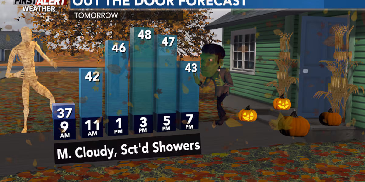
Ghostly clouds and some scary scattered showers are anticipated for Halloween on Friday. If you will be out and about trick-or-treating late Friday afternoon into the evening with the kids, be sure to bring along the umbrella/rain gear, and have at least a couple of layers on, along with the costume. Temps on Friday top out in the mid to upper 40s. Trick-or-treat time, temps will be going from the mid 40s to around 40.
The weekend will feature cooler conditions as November gets underway. Mostly cloudy on Saturday, with a chance of rain/snow showers, especially during the morning. Highs in the low 40s. Breezy on Sunday with a mix of sun and clouds. Highs in the mid to upper 40s. It will be brisk at Lambeau Field for the Packers game on Sunday afternoon, don’t forget the wind breaker and sweatshirt.
A chance of rain/snow showers Saturday, breezy and a bit milder Sunday(WSAW)
Looking ahead
The new work week will be a bit milder with a good deal of sun on Monday, but windy. Wind gusts up to 35 mph are possible. Highs near 50. Some sun Tuesday, while the clouds are back on Wednesday with a chance of showers. Breezy. Highs in the low 50s. Partly cloudy on Thursday and a little cooler with highs in the upper 40s.
The First Alert Weather 7 Day Forecast(WSAW)
Click here to download the WSAW News app or our WSAW First Alert weather app.
Copyright 2025 WSAW. All rights reserved.