First Snow Of The Season Is Ahead For Parts Of The Midwest, Northeast, Including Lake-Effect Snow
First Snowfall For Parts Of Northern US
Parts of the Midwest and East may see their first snow of the season through early next week, including bands of lake-effect snow that could lead to accumulations and slippery travel in the Great Lakes snowbelts and northern New England.
This snowy forecast is all because of a potent, but brief, cold outbreak that will dive through the Midwest, South and East. For more on the cold forecast details, check out our forecast here.
Snow Timing
– Saturday recap: Part of the Dakotas, Minnesota and Iowa saw snowfall reports between 1-6 inches, which was enough to cause some minor delays and impacts.
Especially since people often have to relearn driving in winter conditions when the first seasonal snowfall occurs.
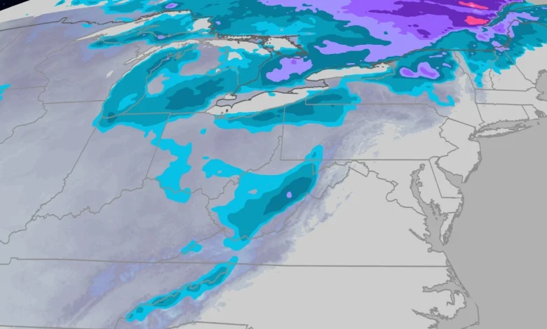
– By early Sunday morning: Some wet snow is possible from eastern Iowa into the western Great Lakes (Wisconsin, northern Illinois, northern Indiana, Michigan and northwest Ohio), including Chicagoland, Milwaukee and Detroit.
– Sunday: Lake-effect snowbands over at least the western Great Lakes snowbelts, including Michigan, Indiana, possibly into parts of Chicagoland. Lake-effect snow may then develop later over the eastern lakes’ snowbelts in northern Ohio, northwest Pennsylvania and western New York. Snow showers may also spread through the western Great Lakes into the Ohio Valley and the central and southern Appalachians.
– Monday – Tuesday: Lake-effect snow may continue in the Great Lakes before tapering off from west to east. Leftover snow is possible in the Adirondacks of upstate New York, high country of northern New England and Appalachians.
(MAPS: US Daily Rain, Snow Forecast)
How Much Snow?
Lighter Amounts
For most, any accumulating snow will be light, on the order of an inch or less, and mainly on grassy areas and the tops of vehicles. That includes any accumulations on the Illinois side of Chicagoland, the Northern Plains and other lower elevations outside the Great Lakes snowbelts.
While roads in these areas may remain wet during the day as falling snow melts on warm ground, roads could become slick at night as temperatures plunge and any falling snow starts to accumulate on pavement, especially bridges and overpasses.
More Significant Accumulations
The Great Lakes snowbelts from Michigan into northern Indiana, northeast Ohio, northwest Pennsylvania, southwest New York, as well as the high country of West Virginia, upstate New York and northern New England could pick up several inches of accumulations through Tuesday.
That could be enough to make roads slushy and slippery, especially at night, by late Sunday into Monday. Keep this in mind for your Monday and Tuesday commutes in these areas.
(MORE: What November Weather Is Typically Like)
How Early Is This First Snow?
For many of the areas that could see their first accumulating snow — at least 0.1 inch — of the season, November is typically the month that happens.
That includes Buffalo (Nov. 8), Chicago (Nov. 18) and Detroit (Nov. 19), according to NOAA 30-year averages.
This “first snow” is a tad late in parts of the Northern Plains. Bismarck, North Dakota, usually sees their first 0.1 inch of snowfall by Oct. 28, and is about 3 to 4 inches behind their average seasonal snowfall pace through Nov. 5.
(MORE: When You Typically See Your First Snow)
Month of the average first accumulating (0.1 inches or greater) snowfall of the season, according to 30-year average statistics.
(Data: NOAA)
What are your thoughts about seeing snow in the forecast? Leave us a reaction and a comment below. We’d love to hear from you.
Jonathan Erdman is a senior meteorologist at weather.com and has been covering national and international weather since 1996. Extreme and bizarre weather are his favorite topics. Reach out to him on Bluesky, X (formerly Twitter) and Facebook.