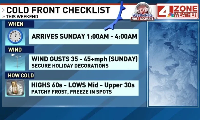
SAN ANTONIO – After a sunny and unseasonably hot day Saturday, changes are coming. A strong cold front will blow through the area between one and four in the morning Sunday, bringing gusty winds out of the north at 35-40+mph. These winds will stick around through much of the day, with afternoon winds still gusting to 30mph.
A Wind Advisory will be in effect from 3am – 6pm Sunday. The strong winds as well as a lack of humidity will result in dangerous fire conditions across South Texas. Because of this, a Red Flag Warning will be in effect from 9am – 9pm Sunday.
Temperatures will also be noticeably cooler Sunday, with highs in the upper 60s to near 70. Colder air settles in by Monday morning as most areas will fall to the mid to upper 30s. Some frost will be possible in spots, or maybe even a freeze in portions of the Hill Country. The afternoon only warms in the lower to middle 60s with sunny skies.
Tuesday morning is also cold in the middle 30s before a quick warmup mid to late week. Highs will climb back to the 80s by Wednesday.
CLICK HERE TO VIEW OUR INTERACTIVE RADAR
TODAY:
Sunny, Very Hot Again
HIGHS: 88 – 92
WINDS: S 5 – 10mph
Another very hot day with sunny skies. Strong cold front will be surging south across Texas but will not reach our area until after midnight Saturday night.
SUNDAY:
Windy, Much Cooler
HIGHS: 67 – 71
WINDS: N 15 – 30mph (Gusts 35 – 45)
Very windy through the morning to early afternoon as cooler air is moving in behind the cold front.Winds will slowly weaken into sunset Sunday evening to a steady breeze. Temperatures will struggle despite full sunshine holding in the upper 60s to near 70 then drop after sunset.
MONDAY:
Sunny, Cool
HIGHS: 61 – 65
WINDS: N 6 – 12mph
Comment with Bubbles
BE THE FIRST TO COMMENT
A chilly start in the 30s for many. Sunshine will increase temperatures into the lower to middle 60s for the afternoon.