Published on Nov. 9, 2025, 10:21 PM
Updated on Nov. 10, 2025, 12:20 PM
Portions of Quebec could see up to 30 cm of snow between the two rounds of precipitation into the day Monday
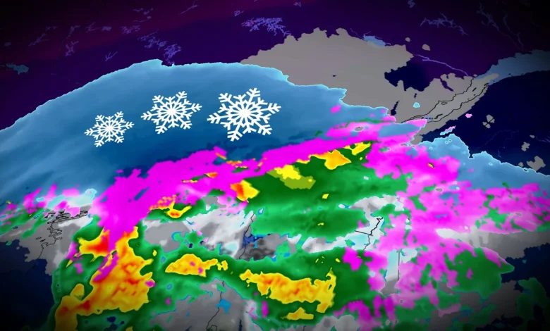
A robust early-season snowfall pushing across Quebec will leave behind a hefty coating to begin the new workweek. Some areas could see up to 30 cm of accumulation by Tuesday morning.
The first wave continued through Sunday night, followed by a second ‘bonus’ bout of wintry precipitation during the day Monday.
RELATED: Why the first snowfall of the season can catch drivers by surprise
Difficult travel with more snow on Monday
Snow began across much of Quebec during the day Sunday as a low pressure system pushed east into the region. Temperatures nudged just above the freezing mark in Montreal on Sunday night, bringing a wintry mix and eventual transition to rain through the overnight hours. Montreal will switch back to light snow through Monday morning, with a wintry mix continuing farther northeast.
A wintry mix—including rain—will develop north of Sorel toward Trois-Rivere and into Quebec City as warmer air is drawn north into the region on Monday.
We’ll see another wave of low pressure lift north into the province, generating a second round of snowfall for much of southern Quebec, including Montreal, Sherbrooke, and Drummondville.
SEE ALSO: Winter-proof your home with a heat pump that even works in -30°C
An additional 5-10 cm of snowfall
Montreal proper could see 3-5 cm of additional accumulation from this second bout of snow on Monday, with 5+ cm in the Eastern Townships. Saguenay is in line for around 10 cm of snow during the day Monday, with higher totals possible in the mountains north of Quebec City.