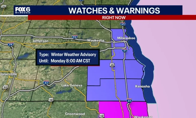
MILWAUKEE – The winter weather advisory for parts of southeast Wisconsin ended at 8 a.m. on Monday, Nov. 10.
The advisory impacted Milwaukee, Racine, and Kenosha counties, where heavy lake effect snow can produce 2″ to 5″ of snow with locally higher amounts possible if the snow band(s) persist longer and/or produce heavier rates of snowfall during this time.
Heavier amounts of snow and higher impacts continue from Lake County in Illinois through Chicago, Valparaiso, and South Haven. Northerly winds are moving very cold air over the warmer waters of Lake Michigan, creating concentrated bands of heavy snow.
Depending on the orientation of the winds, this can move the lake effect snow bands into various areas in Wisconsin, Illinois, Indiana, and Michigan.
Trends are continuing to favor an intense band that can bring heavy snowfall to some lakeshore areas. There will be a sharp cutoff gradient of heavy snow to light snow, all depending on where the snow band sets up.
There is a slight chance that the lake effect snow could stay more over the lake if the winds stay more out of the north. That would cut down on the amount of snow that southeast Wisconsin can see. However, most models are trending at pushing the band into Milwaukee, Racine, and Kenosha counties, causing snow to accumulate 2″ to 5″.
Snow is going to move in during the evening hours when most people will be at home and sleeping, but due to the cold temperatures of the air and ground, snow will likely cause travel impacts Monday morning. It is not recommended to drive in lake effect snow due to the intense low visibility that can occur.
Plan for extra travel time tonight and into Monday morning as snow will likely stick on the pavement.
Your Fox6 Weather experts are watching this closely and will have you covered.
The Source: Information in this report is from the FOX6 Weather Experts and the National Weather Service.
Winter WeatherWisconsin