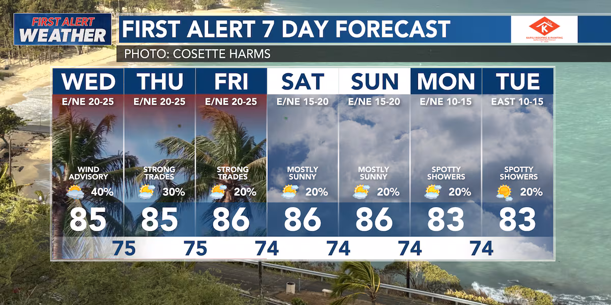
HONOLULU (HawaiiNewsNow) – The National Weather Service has issued a WIND ADVISORY for portions of Kahoolawe, Lanai, Maui, and Hawaii Island.
This advisory will last until 6 AM on Thursday.(HNN Weather)
Expect sustained northeasterly winds in these regions between 25 and 35 miles per hour. Wind gusts could climb as high as 55 miles per hour.
The gusty trade winds are due to a strong high-pressure system that is currently to the north of the island chain, which is expected to peak in intensity today.
Alongside the strong trade winds, a HIGH SURF ADVISORY has been issued for all east-facing shores due to a large swell. This advisory will last until Thursday afternoon.
Rough ocean conditions are also expected during the next several days.
A SMALL CRAFT ADVISORY is currently in effect for all offshore waters.
A GALE WARNING is in effect in the Alenuihaha Channel.
Windward clouds and showers will persist in the forecast for the next few days due to a weak frontal boundary that has moved close to the island chain. Expect increased shower coverage over windward regions.
Download HNN’s weather app for everything you need to plan your day.(Hawaii News Now)
Chief Meteorologist Jennifer Robbins has Hawaii’s most accurate First Alert Forecast every weeknight at 5, 5:30, 6, 9 and 10. Get weather updates every ten minutes on HNN Sunrise, weekdays with Guy Hagi and weekends with Billy V. Meteorologist Drew Davis has your forecasts on This is Now at noon, First at Four and Hawaii News Now at 6:30. And join Ben Gutierrez weekends.
Copyright 2025 Hawaii News Now. All rights reserved.