Met Eireann pinpoints when ‘Arctic airmass’ will hit Ireland with frost, ice and snow to come
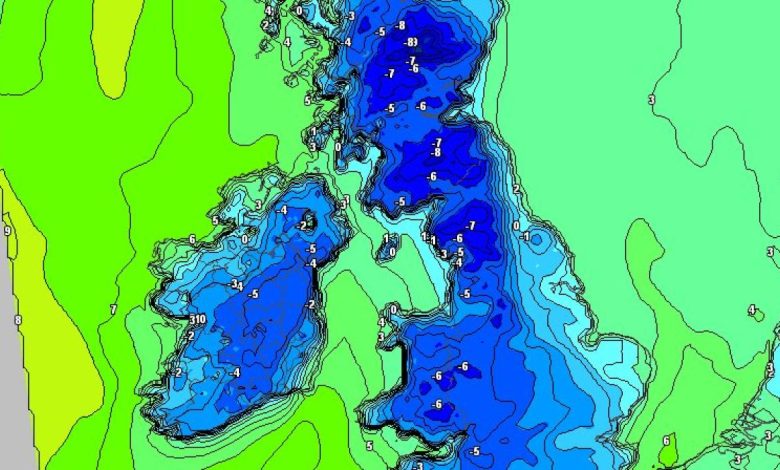
Met Eireann’s weather forecast over the coming days will see temperatures drop to as low as minus three degrees ahead of an ‘arctic airmass’ which will bring some snow in places.
Predictions say that while there’ll be a good lot of dry, bright weather over the coming days, there’ll be showers too, especially in the north and parts of the west, and some will fall as sleet or hail.
There will also be some snow showers too, especially over northern hills. Frost and ice will become fairly widespread for a couple of nights, turning less cold at the end of the week and for next weekend.
On Monday November 17, mist and fog is set to clear in southern parts to leave a cool and a mainly dry day with plenty of sunshine and just the odd isolated light shower.
Cloud will build into parts of the northwest and west later, but holding mostly dry for daylight hours and highest temperatures of 6 to 10 degrees in a light variable breeze.
Later on that night, there will be clear spells and scattered showers from the northwest.
Lowest temperatures of -1 to +3 degrees generally, with some frost and icy patches, away from the west and northwest, where it’ll be a little less cold. Winds will be mostly light variable, becoming light to moderate southwest or west and increasing fresh at times in some western and northern coastal parts.
On Tuesday November 18, rain and drizzle will clear southeastwards early with sunshine and scattered showers following from the northwest.
Some of the showers will be heavy, mainly further north, where there’s a chance of hail.
READ NEXT: LATEST: Louth gardai name five young people killed in horror road crash in Dundalk
It will become breezy especially from the afternoon, with west to northwest winds increasing moderate to fresh and gusty, veering northerly later and becoming stronger, especially further north and in western coastal parts. Highest temperatures of 6 to 10 degrees, but feeling colder, with an added wind chill factor.
Tuesday night will be a cold night with scattered showers becoming more confined to parts of the north and northwest, with a few drifting into some western parts too at times.
Elsewhere, it’ll become mostly dry with long clear spells but some of those showers, especially further north, will turn increasingly wintry, falling as or sleet, with some snow too, especially over higher ground.
It will be rather windy, especially early in the night, with moderate to fresh and gusty northerly winds, stronger along exposed coasts, but the winds will tend to moderate overnight, away from those exposed coasts. Lowest temperatures of -1 to 3 degrees with some frost and ice, especially in sheltered parts.
On Wednesday November 19, it will be a cold day with sunshine and scattered showers, most of those showers in Ulster, Connacht and parts of west Munster, but some possibly drifting into north Leinster too.
Some of the showers will fall as sleet and hail, with some of snow too, especially over higher ground in the north and northwest, where some generally modest accumulations can be expected.
Highest temperatures of 4 to 7 degrees, and feeling even colder with an added wind chill factor from moderate to fresh north to northwest winds, stronger near exposed coasts.
Wednesday night will bring further scattered showers, mainly in the north and northwest, some wintry, though the showers will become more isolated overnight. Elsewhere it’ll be mainly dry with long clear spells. Lowest temperatures of -2 to +3 degrees, coldest in the east and south, with a fairly widespread frost and some icy conditions developing. The moderate to fresh north to northwest winds will gradually ease mostly moderate overnight.
Thursday November 20 will be dry and bright for most with long sunny spells and with just isolated showers, mainly in the north and northwest, still wintry at times. Highest temperatures of 4 to 8 degrees in mostly moderate northwesterly breezes, easing light through the day.
Thursday night will be cold with mostly clear skies at first, but with cloud increasing from the west overnight.
Lowest temperatures of -3 to +2 degrees, with a fairly widespread frost and some icy conditions. Winds will just be light and variable for a time, becoming southwesterly, and increasing moderate to fresh along parts of the west coast later on.
Friday November 21 will be dry to begin in all areas, and while it could stay dry in the east and southeast for daylight hours, rain will gradually spread from the northwest through the day.
Southerly winds will freshen too and will bring in milder air from the Atlantic with the rain. Highest temperatures of 6 to 11 degrees.
Friday night will see outbreaks of rain for a time which will clear southeastwards, with some scattered showers to follow. Lowest temperatures of 3 to 8 degrees, in moderate to fresh southerly winds, veering southwest and easing.
Met Eireann predicts that next weekend looks like the weather will be mixed next weekend with sunshine and showers, some heavy and of hail.
It will not be as cold as during the week, but likely becoming cool enough with temperatures probably coming in around average or a little below and with some frost possible.