SAN ANTONIO – After yet another streak of dry days, we’re about to see our next system move into Texas with a good chance of rain in our viewing region. In fact, we will also be monitoring data trends on potential for locally heavy rainfall that could result in some flooding.
The system of interest is still way out west in California. It’ll take about two to three days to arrive in West Texas then slowly cross our region. The first decent rain chance from this system will be on Wednesday but mainly in our western half of the viewing area. It appears a lead impulse aloft ahead of the main system could zip across Mexico then over our region late Wednesday into Wednesday night with a round of showers and storms. If this indeed occurs, risk of some storms with heavy rain could unfold in our western third of the area.
Tracking upper low over California heading toward Texas
Our in-house computer model, the IBM GRAF is developing storms that train over the same area with high rainfall rates. This scenario repeats through the night into Thursday morning and produces some whopper rainfall totals in excess of 5″. This is an outlier model solution at this time but I do believe it is worth keeping an eye on.
Future radar Wednesday late evening
Rainfall forecast through Thursday 11:00AM from IBM GRAF model
The Weather Prediction Center does have a level 1 of 4 outlook for localized flooding in our western half of the area to cover this scenario. They then put a level 2 of 4 outlook in Thursday to Thursday night that includes San Antonio and Bexar County.
Flood risk outlook Wednesday – Thursday morning from Weather Prediction Center of NOAA
Flood risk outlook Thursday – Friday morning from Weather Prediction Center of NOAA
It appears the main window of showers and storms in and Bexar County will wait till later Thursday into Friday morning. Some of these storms could drop locally heavy rainfall.
Future radar Thursday early evening (global model… not hi-res GRAF given it doesn’t go out that far)
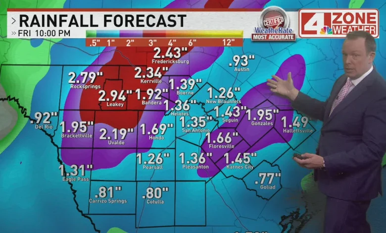
Overall, in and around Bexar County I expect .75″ – 2″+ rainfall. I do expect a 1″ – 3″+ rainfall bullseye in our western third of the area where storms may train over the same area.
5-Day Rainfall forecast (GFS model)
Comment with Bubbles
BE THE FIRST TO COMMENT
As for severe storms, there is just enough on the table where we cannot rule out a couple strong storms with brief wind gusts and maybe some hail.