Tropical Cyclone Fina, a category 1 system, has now developed, located to the north of the Northern Territory. Impacts are likely for parts of the Top End by Friday. Through the early hours of this morning we saw the tropical low pressure system known as 02U gradually moving eastwards to the north of the Northern Territory. During that time there was rapid intensification, more quickly than initially expected, and the system reached tropical cyclone intensity around 4:00 this morning Central Standard Time.
The system looks fairly close to the Northern Territory coast, but at this point it is still located around 370 km to the north-northeast of Darwin. We are seeing showers, rain areas and thunderstorms impacting parts of the Top End, but most of the impacts associated with the developing tropical cyclone are closer to the system over the ocean to the north.
Through the rest of today Tropical Cyclone Fina is likely to move towards the east-northeast, likely reaching category 2 intensity by Wednesday night. As we go into tomorrow the system is likely to make a U-turn, moving back to the south and then gradually southwest towards the Northern Territory northern coastline. Late Thursday into Friday is when more direct impacts may develop for parts of the Northern Territory coastline and the Tiwi Islands.
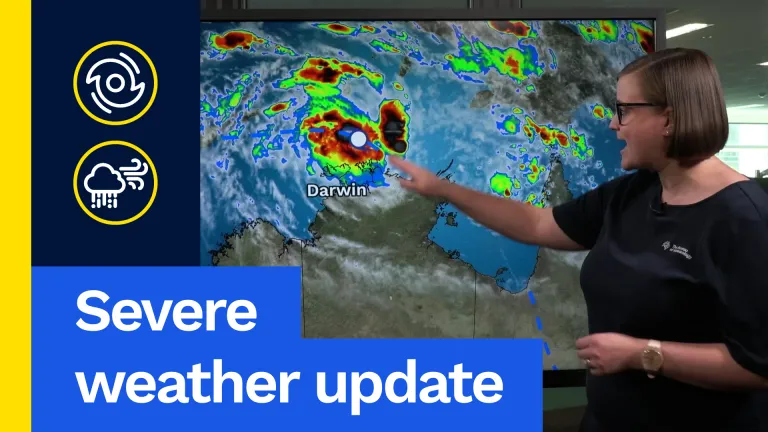
The latest tropical cyclone track map and Tropical Cyclone Watch show this pattern. The blue number on the map indicates the latest analysis for the location of Tropical Cyclone Fina. It is a category 1 system but is expected to strengthen to category 2 by this evening. The system is then expected to move back to the south, then southwest over the next few days, coming close to the Northern Territory coast once again and possibly crossing the far northern part of the Northern Territory across the Cobourg Marine Park by Saturday morning as a category 2 system.
There are still several possible paths, including movement further east or further west staying over water. However, the track map represents the best estimate of how the system will move in the coming days. A Tropical Cyclone Watch is current and is shown by the orange areas on the map. The watch extends from Milingimbi in the east across the northernmost part of the Northern Territory and the Tiwi Islands to Cape Fourcroy in the west of Bathurst Island. In this watch area gale force winds are likely within the next 48 hours. For some areas this may be as early as Thursday, while others may not see gale force winds develop until Friday morning. Locally destructive wind gusts up to 135 km/h may develop for parts of the Northern Territory coastline between Cape Don and Warruwi through late Thursday into early Friday. The end of the week is when more direct impacts from Tropical Cyclone Fina are likely.
After this time Tropical Cyclone Fina is most likely to continue moving southwest through the Van Diemen Gulf, brushing the far western Top End over the weekend. Several possible scenarios remain but the system is likely to pass close to Darwin or possibly make a coastal crossing in the vicinity over the weekend. For Darwin the worst impacts are likely this weekend, including strong gale force or possibly destructive winds, elevated sea state and storm surge, and increased rainfall.
Rainfall totals through Sunday night show the highest totals along the northwestern corner of the Top End and across the Tiwi Islands, with the greatest accumulations where the system passes closest, which may include the Darwin area. This is the time to be prepared and aware of what is coming. Forecasts and warnings are available on the Bureau website, the BOM Weather app and through social media. Stay safe and we will catch you next time.