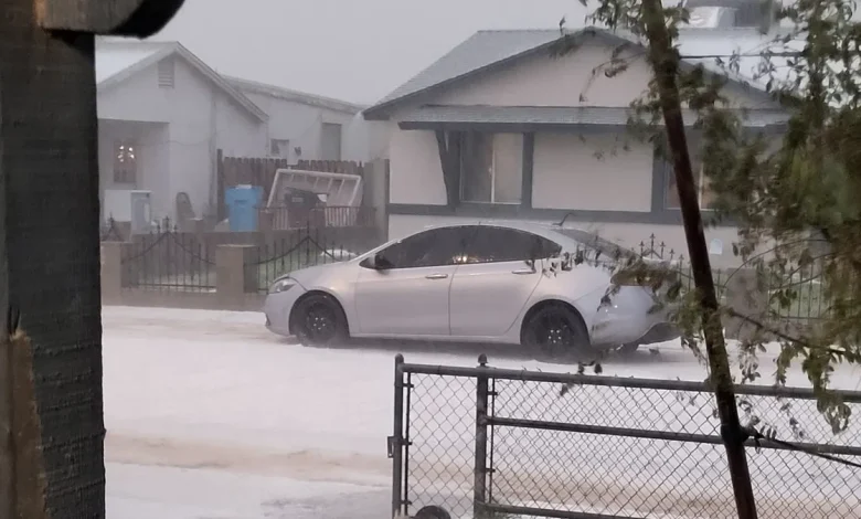
Parts of Phoenix looked more like Flagstaff than the Sonoran Desert as a burst of hail covered roads and yards in a sheet of white during a strong November storm system.
By dusk on Wednesday, Nov. 19, stretches of the West Valley and areas near Ahwatukee were coated with slush as cars crawled through icy accumulations and social media flooded with photos.
Meteorologists say the scene was the product of a cold-core, low-pressure system that lingered over Arizona longer than expected, allowing storms to strengthen and pull in enough cold air for quarter-sized hail to hit the ground intact.
The system created damaging winds and hail, with part of the roof collapsing at the Desert Sky Mall in west Phoenix.
“We had folks in Phoenix and in Tucson with a lot of hail, it ended up looking like snow,” said Erinanne Saffell, Arizona’s state climatologist. “For Arizona, getting this amount of hail is not that usual. We’ve had a good November so far. We’re still getting more precipitation, and that’s a good thing.”
This fall has been unusually wet for much of Arizona. The weather station at Sky Harbor International Airport has recorded 0.29 of an inch so far this month, following 2.26 inches in September and 3.26 inches in October.
Although the hail has melted into the desert dust, stormy weather is still on the horizon for Phoenix before drying out in time for Thanksgiving.
What caused the hailstorm?
Wednesday’s hail core built quickly over the West Valley as a low-pressure system that originated off the California coast slowly moved east. Storms first developed around Avondale and Buckeye, and then strengthened over Glendale, where hail briefly accumulated on streets, sidewalks and grassy areas.
“We had a bit more instability in the atmosphere yesterday that allowed for some more intense storms to develop,” said Alicia Ryan, a meteorologist with the National Weather Service in Phoenix. “That was what we saw yesterday with that well-developed hail core.”
Precipitation accumulations across the Valley fell between half and three-quarters of an inch, though larger pockets with 1 to 1.25 inches of rain were reported in parts of Glendale and west Phoenix.
The system carried a cold-core low and cool surface temperatures that kept hailstones from melting before reaching the ground.
The slow movement of the storm also played a role. Moisture values over central and eastern Arizona were running close to 200% of normal, giving the system more time to develop and produce intense pockets of precipitation.
How does hail form?
Hail forms when raindrops are swept upward into freezing layers of a thunderstorm by strong updrafts. They grow by colliding with more water droplets in the atmosphere.
Some freeze instantly, trapping air bubbles and producing cloudy ice pellets, while others freeze slowly, creating clearer layers.
When the hailstones become too heavy for the updraft to hold, gravity takes over and they plummet to the ground. Their size depends on the strength of the updraft, how long they spend aloft and how much they melt during descent.
“Hail is not super common in Arizona because we see most of our storm activity in the monsoon, which isn’t often favorable for hail,” said Michael Crimmins, a climatologist at the University of Arizona. “In the middle of the monsoon, we don’t see storms get organized enough to allow for the hail formation process.”
During the monsoon, storms often form in hot, moisture-rich environments with weaker wind shear, which prevents them from becoming the tall, well-organized thunderstorms needed for hail to form. These storms tend to collapse quickly and push out strong winds instead, which is why microbursts and dust storms are far more common than hail in July and August.
But Arizona does see hail every year, with higher chances during fall low-pressure systems with cooler temperatures and stronger shear.
Hail is most common in the central Plains, with Colorado, Wyoming and Nebraska seeing the most annually.
Tucson, Phoenix and Flagstaff have all logged near to above-normal moisture this fall, with Flagstaff already at 3.65 inches of November precipitation. Arizona’s snowiest city also saw its first snowfall of the season.
For the Valley and Tucson, this week’s hailstorm was a striking reminder that Arizona’s cool-season storms can still pack a punch.
What’s next in the forecast
The low-pressure system responsible for this week’s hail is moving east, bringing a quieter stretch for the Valley on Thursday, Nov. 20.
“This afternoon going into tonight, we are expecting a period of clearer skies,” Ryan said. “We’re not really expecting any activity to develop today.”
Another low-pressure system is already developing off the West Coast and will move inland into Arizona on Friday, Nov. 21, bringing 20 to 30% rain chances back to Phoenix by the afternoon.
Higher terrain areas north and east of the Valley could see 60 to 70% chances Saturday evening.
Temperatures will stay below normal through the end of the week, with Phoenix highs in the low to mid-60s. By early next week, moisture values drop and Arizona begins a steady warmup in time for the holiday.
“As these low-pressure systems start to exit our region, we should be heating back up to normal temperatures in the low 70s,” Ryan said.
Hayleigh Evans writes about extreme weather and related topics for The Arizona Republic and azcentral.com. Email her with story tips at hayleigh.evans@arizonarepublic.com.