What is the polar vortex? How it can impact snow, freezes in the U.S.
The polar vortex is a large area of circulating cold air above the North Pole. Strong winds keep it contained, but when it weakens, it can wobble and stretch.
- A storm system is expected to bring rain and mild temperatures to the Upstate ahead of Thanksgiving.
- South Carolina may see rain showers leading up to Thanksgiving, but the holiday itself is forecast to be sunny and cool.
If you plan to travel for Thanksgiving over the weekend or early next week, be sure to pack an umbrella and an extra sweater just in case.
South Carolina and much of the East Coast are bracing for a storm system moving northeast, bringing mild temperatures and possible rain as far south as the Carolinas.
“A storm will impact much of the eastern two-thirds of the United States during the busiest travel times ahead of the Thanksgiving holiday as millions hit the highways and head for the airports,” said AccuWeather meteorologist Alex Sosnowski.
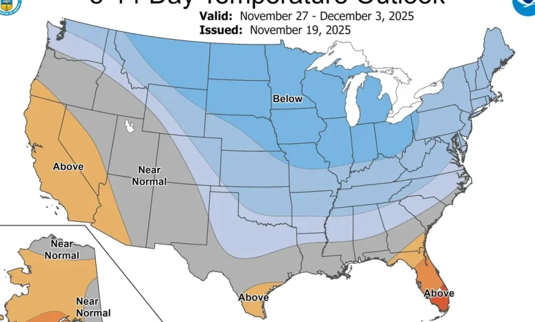
The latest forecast shows a pattern change from the beginning of November, with the eastern United States expected to see milder temperatures at the end of the month.
“Following a warm start to November in the West and a cold start in the East, a significant pattern change is likely later in the month and into early December,” the Climate Prediction Center wrote. “During Thanksgiving week, a colder pattern is likely for the West and the Northern Plains while milder air overspreads the East.”
Here’s a look at what to expect from South Carolina’s weather and whether it could impede holiday travel.
What will the weather be like for Thanksgiving in South Carolina?
Predictions for Thanksgiving week have Upstate South Carolina on the edge of storms expected to impact travel for the holiday.
The National Weather Service forecast on Nov. 21 has rain moving into the Greenville and Upstate area starting on Friday night, Nov. 21, and continuing into Saturday, Nov. 22, but chances are it will be small showers. Moving into the holiday week, people could see even more rain showers on Nov. 25 and 26, with it clearing out for Thanksgiving Day.
The Upstate could see cooler-than-normal temperatures starting on Thanksgiving Day, Thursday, Nov. 27, with highs expected to reach the high 50s, but it will be sunny, according to the National Weather Service.
Could there be travel delays on Thanksgiving?
If you plan to fly or drive a long distance, you may encounter travel delays.
The storm system is expected to hit a large swath of the United States, causing delays due to thunderstorms in the South. If you are headed further north, beware, there could be snow. Here’s the latest:
By Wednesday, Nov. 26, “it seems plausible that thunderstorms could impact travel through Atlanta or Florida,” said Houston-based meteorologist Matt Lanza on his blog “The Eyewall.” “Winds could impact flights in Chicago and Minneapolis,” he said.
By Wednesday, Nov. 26, “the storm will be losing some of its intensity and moisture as it travels from the central states to the Northeast, but given the travel volume, even a few hours of rain can create significant problems on the roads and runways from Washington, D.C., to Philadelphia, New York City and Boston,” noted AccuWeather meteorologist Paul Pastelok in an online forecast.
Will a polar vortex impact South Carolina? Could it snow?
We are getting closer to the months when the polar vortex starts to stir, bringing cold temperatures to the South. But the stormy weather and slightly cooler temperatures we expect to see ahead of Thanksgiving Day aren’t part of it.
The polar vortex is not a synonym for “cold snap,” according to the Polar Vortex Blog at Climate.gov, and it’s not the only weather pattern to blame for blasts of cold air.
What is a polar vortex?
The polar vortex is a gigantic, circular area of cold air high up in the atmosphere that usually spins over the North Pole.
It’s a normal pattern that’s stronger in the winter and usually keeps the coldest weather bottled up near the North Pole when it is “strong.” If the polar vortex weakens or even splits, frigid air pushes southward toward the U.S.
What’s the difference between an Arctic air mass and the polar vortex?
Arctic air masses originate over the Arctic or Antarctic regions and are very cold. They invade lower latitudes at irregular intervals, according to the weather service.
This arctic air tends to be colder than polar air.
The polar vortex is a large area of low-pressure and cold air surrounding both of the Earth’s poles, according to the weather service. It always exists near the poles.
What are the chances of snow in South Carolina for winter 2025?
Slim.
On average, South Carolina sees around 4 inches of snow per year, according to data from the National Weather Service. But for the 2025-26 winter, the predicted above-average temperatures could keep the white stuff at bay.
While the weather agency makes these predictions every year, they are the most likely scenario for weather patterns. People should always check local forecasts for the most up-to-date weather.
The weather service’s outlook for precipitation shows parts of the Upstate have a slightly below-average chance of winter precipitation, and as you head further south and east, the chance of precipitation becomes slimmer.
When is the first day of winter 2025?
The first day of winter is Dec. 21, 2025, at 10:03 a.m., according to the Old Farmer’s Almanac.
Joyce Orlando is the Carolina Connect Editor and covers trending topics in North and South Carolina.
Nina Tran and USA TODAY contributed to this report.