Weather Headlines
- NEXT 9 HOURS: Another foggy morning
- SHORT TERM: Temperatures drop
- LONG TERM: Wintry weekend after Thanksgiving
Latest Forecast
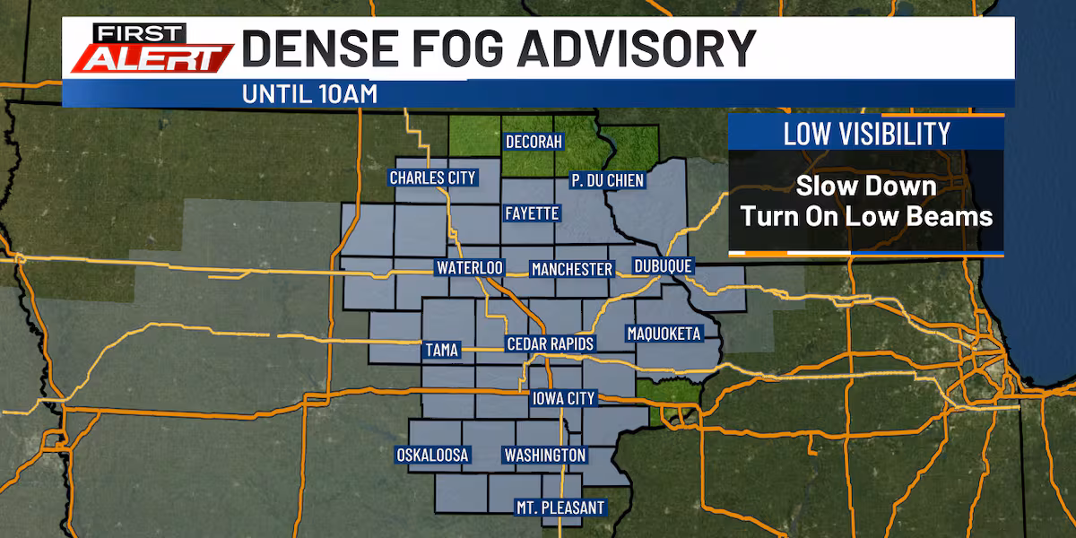
Foggy again with colder weather on the way
CEDAR RAPIDS, Iowa (KCRG) – Visibility could be reduced for the morning commute again this morning.
The latest satellite and radar data.
(KCRG)
Along with the fog comes a bit of drizzle this morning, but a better chance of a few passing showers as a cold front moves through the area this afternoon/evening.
Today’s Forecast(KCRG)
Clouds will persist for the most part, though a peek of sunlight can’t fully be ruled out. Behind this approaching cold front, winds will shift from the south and southwest to the west and northwest. Gusts will increase, too, with speeds potentially in the 30 to 45 mph range on Tuesday night into Wednesday.
5 Day Wind Forecast(KCRG)
A few light snow showers could occur Tuesday night north of U.S. Highway 20, though substantial accumulation looks unlikely. A dusting of snow may occur, especially closer to the Iowa-Minnesota border. Watch out for a slick spot if travelling at night up in that area.
Pinpoint FutureCast(KCRG)
Temperatures will turn sharply colder as a result of this, falling below normal for late November and staying there until the end of the 9-day forecast.
The good news is that we should see the weather remain quiet on Wednesday into Thursday, with no precipitation expected. The only hazard for travelers will be the gusty winds, but even those should turn somewhat lighter on Thanksgiving itself. If you’re hitting the road, or taking to the skies, around this time, things should be generally in good shape.
Thanksgiving travel stays navigable for most of the week, but things could get a bit messy this weekend.(KCRG)
Friday starts out dry and cold, with lows in the 10s and wind chills potentially down in the single-digits to low 10s above zero. Most of the day is just mostly cloudy, but precipitation begins to threaten eastern Iowa by the evening into the night. This initially develops out toward the Missouri River area in western Iowa in the afternoon, sliding eastward into the night.
Some precipitation, likely in the form of snow, could return by Friday night.(KCRG)
The exact placement and intensity of this precipitation is still somewhat unclear, so it’s too early to be talking about exact amounts. However, the potential for accumulating snow that could lead to slick roadways is out there. The highest chance of these kinds of outcomes will be on Friday night into early Saturday.
The potential for snow that accumulates increases Friday night into portions of Saturday.(KCRG)
Then, the potential for a mix of rain and snow will carry on throughout the rest of the weekend. However, the latest data we have coming from computer models that we use to help make our forecasts does not paint a certain picture here.
Changes to the forecast are likely during this time frame, whether it be to the timing or type of precipitation. If you have travel interests for the weekend after Thanksgiving, your best bet is to stick with us for more updates as we get a bit closer. We’ll provide them here on KCRG.com, the KCRG First Alert Weather app, and KCRG-TV9.
Copyright 2025 KCRG. All rights reserved.