NASHVILLE, Tenn. (WSMV) – Heavy rain and gusty winds to start off our Tuesday in Middle Tennessee with some gusts between 30-40 mph in far west Middle Tennessee.
FIRST ALERT WEATHER DAY – TODAY
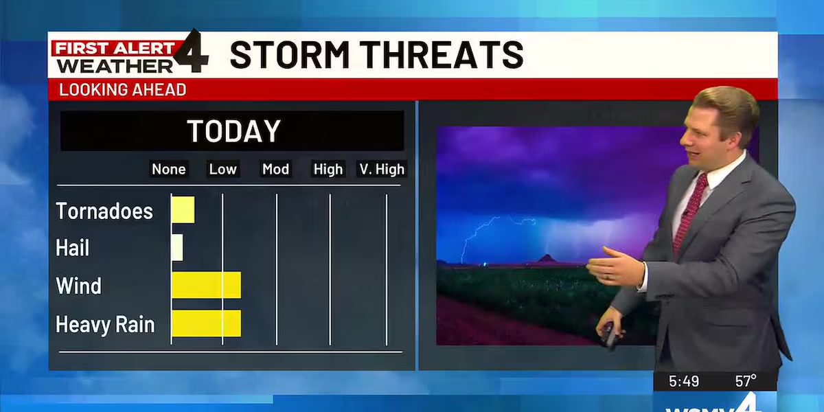
There remains a low end threat for a strong thunderstorm or two this morning and this afternoon in far southeast Middle Tennessee. The primary threat will be more downpours and some higher wind gusts as well. Though rainfall coverage will get much more isolated this afternoon, a storm could still pop-up the farther south and east we are today.
A low end threat for a strong thunderstorm or two Tuesday morning and this afternoon in far southeast Middle Tennessee.
WEDNESDAY’S FORECAST
Colder but calmer weather is expected for the rest of the week, including on Thanksgiving day.
Wednesday will be partly cloudy and cooler with temperatures staying in the 50s for much of the area. But, we are expecting NO travel issues throughout the area on Wednesday.
THANKSGIVING DAY
Thanksgiving day will be cold in the morning with temperatures near freezing. The afternoon will be chilly with temperatures struggling to get out of the 40s for most the area. Lows Thursday night will fall to below freezing across Middle Tennessee and Southern Kentucky.
FRIDAY’S FORECAST
Another cold morning on Friday with most of us waking up in the 20s. The afternoon will stay chilly with highs in the upper 40s to the low 50s under a mostly cloudy sky.
WEEKEND OUTLOOK
Saturday will be partly cloudy with temperatures in the mid to upper 50s. More clouds will mix in on Sunday and there will be a couple of rain showers in the afternoon. Highs on Sunday make it back to near 60.
Copyright 2025 WSMV. All rights reserved.