Winter Storm Watch expands into Lower Michigan, now 16 counties including Traverse City, Cadillac
A winter storm watch has been issued for 12 counties in northern and northwestern Lower Michigan. The winter storm watch is for the time period of Wednesday afternoon to Friday morning. A winter storm watch is also in effect for the same time period in the eastern U.P.
This means, as of this Tuesday morning, you still have 30 hours before heavy snow and blowing snow develops over Northern Michigan.
Here’s the radar forecast from 8 a.m. Wednesday to midday on Thanksgiving.
It’s a rather odd changeover to snow. Rain showers will occur early Wednesday morning over Lower Michigan. The rain will change to snow first over southwest Lower Michigan Wednesday morning, and then the changeover works its way north Wednesday afternoon.
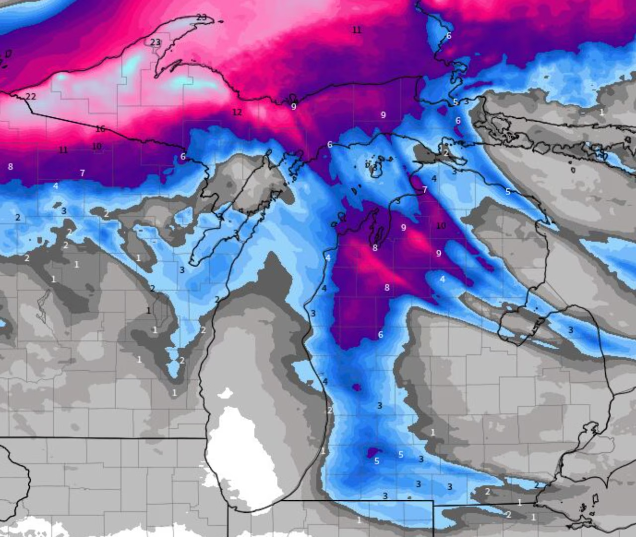
Radar forecast from 8 a.m. Wednesday, November 26, 2025 to noon Thanksgiving.NOAA
Eventually by Wednesday night, the snow areas will take on the classic lake-effect snow areas. The entire Traverse City area will be in the heavy snow chance. Also Cadillac, Houghton Lake, Kalkaska, Charlevoix, Grayling, Gaylord and Mancelona will get into the heavy lake-effect snow.
Leelanau County southward through Manistee, Ludington, Muskegon, Holland and South Haven aren’t officially in any sort of advisory yet, but will likely need to be added. The strong wind often blows the heaviest snow inland 10 to 20 miles.
Kalamazoo sits in a favorable spot for heavy snow also in this situation.
Grand Rapids will have snow, but not as heavy as northwest Lower or Kalamazoo.
The periods of heavy snow will continue until early Friday morning, and then taper off by noon Friday at most locations.
Here’s the expected total snowfall through midday on Thanksgiving. It will be heavy snow with lots of drifting due to wind gusts up to 40 mph.
Total snowfall forecast through midday on Thanksgiving.NOAA
Anywhere in the purple or pink shaded areas around the whole Traverse City area can expect six inches of snow to as much as 10 inches of snow.
Southwest Michigan, from Holland, Allegan and South Haven to Kalamazoo should have four to eight inches of snow by midday on Thanksgiving.
One longer band of lake-effect snow may extend into northeast Lower Michigan, giving two to four inches of snow in isolated areas north of Bay City.
The rest of southeast, south-central and central Lower Michigan will only have an inch or two of snow.
Road conditions will quickly become dangerous Wednesday afternoon over all of western Lower Michigan.
The Upper Peninsula will have even heavier snow, with Friday morning totals up to 24 inches at some western U.P. locations.
If you are looking for the safest travel times to head north, get to your destination before noon Wednesday, and don’t plan on some road improvement until near noon Friday.
Watch for regular updates at Mlive.com/weather.