Another Arctic blast is set to hit the UK, bringing freezing temperatures to the East Midlands and even snow in parts of the country. The Met Office has said another snowstorm could be just days away, brining up to 17cm of the white stuff in some areas.
Changeable and unsettled conditions are expected across the UK during this period. Low pressure systems will tend to dominate meaning showers or longer spells of rain for much of the UK, though there will likely be some brief settled interludes., according to the Met Office.
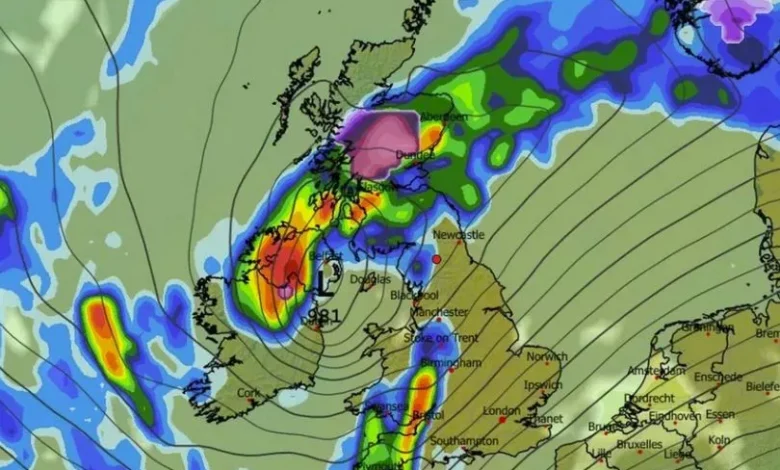
According to the UK forecast, some heavy rain or showers are expected, most often in the west, although with a risk some of this could spread to other areas at times. Snow will probably be confined to high ground in the north.
It adds: “Periods of strong wind are possible, especially around coasts and if any deep areas of low pressure form in the vicinity of the UK. Some short-lived spells of drier weather are possible, particularly in the southeast. Temperatures will likely be close to average or slightly above overall.”
BBC Weather’s forecast for December 1 to 7 states: “During the first week of December, the trend towards high pressure dominance should continue, so there should be drier conditions for most of the UK.
“The high pressure is most likely to be positioned in such a way that it will be accompanied by a relatively mild air mass, meaning that daytime temperatures should be widely near or a little above the December average. Nevertheless, occasionally clear and rather calm conditions overnight should mean risks of frost and perhaps fog patches.
“Although most regions should be drier than normal, a couple of Atlantic frontal systems should nudge towards the UK, bringing occasional rain chances, mostly to northern and western regions, and probably most especially for Scotland, where some wintry precipitation could be possible over high ground.
“Elsewhere, a weakening front or two could bring a little rain farther southwards and eastwards, so it’s unlikely to be completely dry. The risk to the forecast is that high pressure will position itself differently – more strongly over Scandinavia, for example – which would mean chances of colder flows developing.”
Weather forecast for East Midlands
Today:
Bright spells for most. Occasional showers, particularly along the Lincolnshire coast and these could be heavy at times with a risk of hail. Showers increasingly confined to coastal fringes through the day as winds ease and skies clear. Feeling cold. Maximum temperature 6 °C.
Tonight:
Becoming dry and increasingly clear overnight with temperatures falling quickly into the evening as winds ease, with a widespread frost developing. Minimum temperature -2 °C.
Wednesday:
A largely fine day Wednesday. Mostly clear and frosty to start. Breezier and gradually milder by the late afternoon and evening with spells of light rain. Maximum temperature 6 °C.
Outlook for Thursday to Saturday:
Breezier and remaining much milder through Thursday and Friday with spells of rain. Winds easing into Saturday but remaining unsettled and forecast confidence reduces.