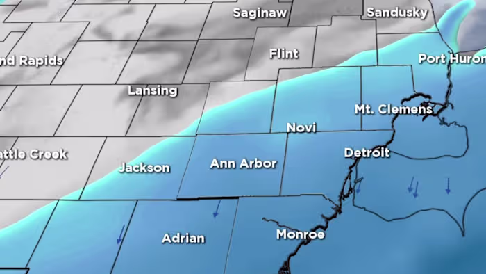
Southeast Michigan woke up Sunday to a fresh blanket of snow, with most communities picking up three to six inches from the weekend system.
Roads were snow-covered early. Although crews were able to clear most main roads on Sunday, light snow showers could leave a dusting.
Moisture left behind on untreated residential streets could refreeze overnight as temperatures tumble. Drivers and pedestrians should be prepared for a few slick spots Monday morning.
—> List of snowfall totals in SE Michigan by county following overnight winter storm
—> Check school closings in Metro Detroit
Monday
Monday will bring increasing clouds with highs near 30 degrees across Metro Detroit. (WDIV)
After a break in the widespread snow Sunday, cold air settles in for the start of the week. Monday will bring increasing clouds with highs near 30 degrees across Metro Detroit, while areas in the Thumb hold closer to the upper-20s.
The next round of accumulating snow arrives Monday night and continues into early Tuesday. This system is not as strong as the weekend storm, but it will still drop around a half-inch to two inches of new snow for Metro Detroit.
Even light snow at the wrong time can cause slowdowns, and this one is timed to affect the Tuesday morning drive.
Anyone heading to work or school early Tuesday should build in extra time and expect slick conditions.
Tuesday and Wednesday
Tuesday will stay cold with highs around 30 degrees degrees before breezy and mostly cloudy weather continues midweek.
A chance of light snow returns late Wednesday, introducing another quick round of minor accumulation for parts of the area.
Thursday and Friday
The bigger story behind these quick-moving systems is the push of much colder air arriving late week. By Thursday and Friday, highs struggle to reach the lower- to mid-20s in some northern communities and the upper-20s closer to Metro Detroit.
Overnight lows fall into the teens, with single-digit readings possible across the Thumb and outlying suburbs. This will be the coldest stretch of the season so far and a noticeable change for anyone heading out early or late.
Another chance for light snow arrives Friday night into Saturday morning, followed by highs in the upper-20s and lower-30s through the weekend. Temperatures remain below normal across all of Southeast Michigan.
In short, after today’s three to six inches of snow, the region faces a reinforcing shot of cold air and one more light round of snow Monday night into Tuesday. Plan for a chilly week, watch for refreeze Sunday night, and be prepared for a slower commute early Tuesday.
Snow totals from Nov. 29-30 were generally greater west of I-75. Some of the lowest totals, three to four inches, were on the east side of Metro Detroit.
Most Southeast Michigan communities picked up three to six inches from the Nov. 29-30, 2025 weekend snowstorm. (WDIV)Most Southeast Michigan communities picked up three to six inches from the Nov. 29-30, 2025 weekend snowstorm. (WDIV)
—> List of snowfall totals in SE Michigan by county following overnight winter storm
Share your snow photos with Local 4 at MIPics.
Copyright 2025 by WDIV ClickOnDetroit – All rights reserved.