WPSD meteorologists have activated a Weather Authority Alert for Monday evening into Tuesday morning for the first potentially impactful winter weather event of the season.
We currently have a Winter Weather Advisory in place for most of West Kentucky, Northwest Tennessee, and the Missouri Bootheel beginning at 6 p.m. this evening. The National Weather Service is working on adding counties to that advisory.
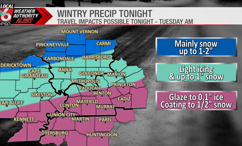
We are expecting some light mixed precipitation to begin moving into the area from the west between 4-6 p.m. Initially, this may be some cold rain, mixed with occasional sleet and snow. As temperatures cool through the evening, some of this light rain could begin to freeze, forming a glaze on some surfaces and untreated roads. Eventually, more of this will change to snow, especially for areas along and north of the Ohio River. Some areas of Southern Illinois could see up to an inch of snow, possibly 1-2″ near I-64. Areas of Kentucky and Tennessee are likely to see less than an inch of snow — and some areas may not see any.
It is possible that some areas, especially over Kentucky and Tennessee, may not see more than some flurries or freezing drizzle. Freezing drizzle can be quite deceptive, because while it doesn’t look like much, it doesn’t take much to cause problems — especially on bridges and overpasses. With temperatures in the 20s tomorrow morning, any areas of light icing could be quite slick.
While this is not a major winter storm, it is the first potential winter weather impacts of the season and we want to alert folks to be extra cautious. Allow extra time for travel tonight and tomorrow morning. Slow down, and be vigilant of potential black ice. With sunshine returning tomorrow afternoon, we’ll see a quick improvement in conditions.