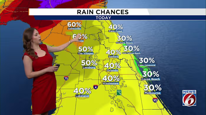
ORLANDO, Fla. – A developing low over the northern Gulf will race northeast on Tuesday, dragging a cold front through Central Florida into the afternoon.
Ahead of that front, scattered showers and a few lightning storms will move through during the day, with most of the rain ending around sunset as activity shifts offshore. Any storms that develop will zip through the area quickly, producing lightning, strong wind gusts (40 to 55 mph) and brief bursts of heavy rain.
[VIDEO BELOW: Get most out of free News 6 Weather App]
Temperatures remain warmer than normal, topping out in the low to mid-80s before the front arrives. Once it passes, overnight lows drop into the mid-50s north and west of I-4.
The middle of the week brings a quick little break. High pressure settles over the area through Friday, keeping conditions dry and comfortable.
Highs Wednesday will feel more seasonal, with temperatures in the low 70s near I-4 and the mid- to upper 70s southward, followed by a chilly night with lows dipping into the upper 40s to around 50 degrees.
A gradual warming trend sets in Thursday and continues into Friday, pushing highs into the upper 70s and low 80s by the end of the week.
[VIDEO BELOW: Candace Explains: Measuring distance of lightning]
Next System
Another weather-maker arrives over the weekend as a new system develops in the western Gulf and pushes another cold front toward Florida. Forecast models disagree slightly on timing, but the front should move into the state sometime between Saturday night and Sunday.
Moisture increases ahead of it, bringing back rain chances to 30-40%.
Highs remain warm Saturday in the upper 70s to low 80s, then slide back into the 70s behind the front on Sunday.
Daily Forecast
The News 6 Weather team ensures you’re always on top of the day’s weather.
Copyright 2025 by WKMG ClickOrlando – All rights reserved.