Snow could fall across the UK by the end of this week as advanced weather modelling maps indicate as much as 4cm is expected in some parts of the country
Snow falling (in purple) in Wales, England and Scotland at 6pm on Friday(Image: WXCharts)
Snow could return to the UK this week as advanced weather modelling maps show an Arctic blast bringing as much as 4cm to some parts of the country.
The ECMWF weather model shows an Atlantic system sweeping across the UK on Friday. Most places can expect rain, although the weather charts suggest the precipitation might also come down as snow.
At around 6pm on Friday, the maps show heavy snow coming down in North Wales, with some light flurries also possible in the Lake District. A band of rain is tracked to move across southern and central England, with Northern Ireland also set for some heavy downpours.
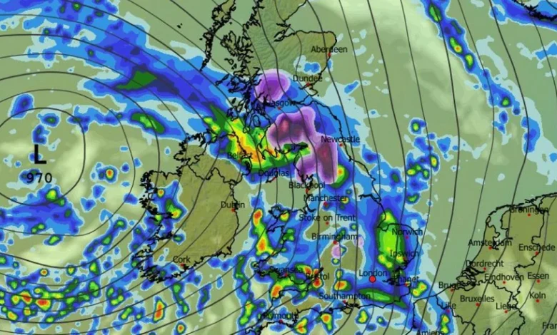
Snow will move northward on Friday, weather maps suggest(Image: WXCharts)READ MORE: UK snow forecast as Brits face being buried in Arctic blizzard lasting 21 hoursREAD MORE: UK snow: 330-mile wall of snowfall batters Britain as weather maps turn WHITE
The snow is then expected to move northward, with heavy flurries in the far north of England and southern Scotland by 9pm, according to the weather maps. Some light snow could also fall in the Midlands, just south of Birmingham, around this time. By midnight, most of the snow looks to be focused in central and northern Scotland, although some sporadic flurries could continue in the north-east of England.
Snow depth charts for midnight on Friday show the white stuff settled on the ground in parts of the Midlands, Staffordshire, Yorkshire, the Lake District, the Pennines, as well as southern and northern Scotland. The greatest accumulations are expected in Galloway Forest Park where 4cm could settle, the data suggests.
Snow hitting Scotland at midnight on Friday(Image: WXCharts)
The Met Office is yet to predict snow for this week. Its forecast for Thursday to Saturday states: “Further spells of rain and showers will move across the country. A risk of fog patches for many on Friday morning. Temperatures around the seasonal average.”
The Met Office forecast for December 6 to 15 adds: “Likely a continuation of the unsettled conditions seen for much of the week with further showers or some longer spells of rain affecting much of the country. On Saturday a frontal zone is expected to move east and this could bring a spell of locally heavy rain, particularly on hills exposed to the strong southerly winds.
Snow depth (cm) at midnight on Friday(Image: WXCharts)
“Behind this turning brighter but with showers, some of which could be heavy and thundery. Its possible we could then see yet more organised, locally heavy rain move across most areas on Monday.
“Generally temperatures will be close to average, but it will likely feel quite chilly in the often wet and breezy conditions. However we are unlikely to see much in the way of frost or fog in this unsettled spell.”