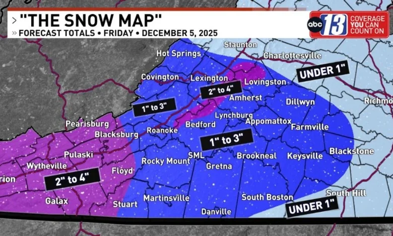
LYNCHBURG, Va. (WSET) — SUMMARY: Many of us have a snow day ahead! The first snow of the season arrives Friday morning. 1” to 3” snow totals will be most common in the ABC13 area.
“THE SNOW MAP”: This is my first snow map for Friday. I’ll post a revision on Thursday PM before the snow begins.
WEATHER ALERT DAY: The ABC13 Weather Team is issuing a Weather Alert Day for Friday.
WINTER WEATHER ADVISORY LIKELY: The NWS issues these, and I would guess this will be a Winter Weather Advisory. Winter Storm Warnings are issued for snow totals 4” and higher, but I’m not forecasting that much snow.
1” to 3” SNOW TOTALS : Roanoke, Danville and Lynchburg. These forecast totals might be a little high due to the dryness of the air, but this is what I have for now.
HIGHER TOTALS FOR MOUNTAINS: Over 3” is possible for the mountains. Highest amounts: SW Virginia mountains, plus where I’m drawing in the higher terrain of Bedford, Amherst and Nelson counties.
Snow moving across Virginia (WSET)
SNOW ARRIVES EARLY FRIDAY: Snow begins before sunrise. All locations in ABC13 area should awaken to falling snow on Friday morning.
SNOW FALLS ABOUT 9 HOURS: Once the snow begins, snow will continue into Friday lunch. If this was a heavy/wet snow, you would expect higher snow amounts.
“DRY” SNOW: And of course, all snow becomes wetter when you drive on it, creating friction/heat.
SNOW INTENSITY: Light to moderate. “Gentle.” Light wind.
SNOW ENDS on Friday afternoon, with little melting occurring.
SCHOOL IMPACTS: We typically see a lot of 2-hour school delays during a Winter Weather Advisory. But I think we’ll see school cancellations as snow will be falling when morning bus routes would normally be active. Your school will make the best decision!
SPECULATION: I told my wife, Elizabeth, who is a school teacher, that she’s probably having a snow day on Friday!
These are my thoughts, so you can prepare accordingly. Check back for updates.