Low temperatures flirt with record cold by Friday morning. We will be within two degrees in Detroit. Winds chills will be even colder with some below zero. The next snow chance is Friday night.
Tonight, we drop into the single digits for lows, so it’s a good night for the heavy coat, hat, and gloves if you’re out for the Lions game. Friday’s still cold but just a touch better than Thursday. Highs climb into the mid 20s, again with intervals of clouds and sun. It’s dry during the day, so no snow issues for commuting, just that deep-winter chill. Friday night, temps hold in the low 20s, which is actually not as harsh as tonight.
Watch the full forecast
Near record cold tonight
This weekend like the previous days, will stay on the cold side but with a small winter weather twist. Saturday will be chilly with highs near 32, low clouds and a few scattered flurries. Overnight into Sunday, temps drop back toward the 20s, and the skies trend cloudy. Sunday itself stays cold with highs around 30 and skies staying overcast with a few snow showers around. So, if you’re heading out this weekend: bundle up. It’s not a forecast for heavy snow or rain, but it’s definitely a good weekend for a warm coat, hat, and gloves.
We’re starting to see a clearer signal for a mid-week snow maker, that could impact the Detroit area. Trends are pointing towards a system that could bring light-to-moderate accumulating snow between Tuesday and Wednesday. The setup is classic for early December with cold air firmly in place while a disturbance is sliding through the Great Lakes. This system will tap into that cold air allowing snow to develop Tuesday morning and become a bit more organized later in the day and into Tuesday night. Some snow may linger into Wednesday morning before tapering off. At this point, totals look modest — a few inches possible — but even that amount could lead to slick roads and slower commutes, especially if the heaviest snowfall lines up with the Tuesday evening or Wednesday morning drive. Confidence is increasing that we’ll see something out of this system, but the exact timing and amounts may still shift a bit as we get closer. Overall, it’s shaping up to be Detroit’s next notable chance at a widespread, measurable snowfall.
Tonight: A mostly clear sky and very cold temps of 8° in Detroit and as cold as 1° in Ann Arbor. The record low for Detroit is 6°. Winds: SW 5 mph.
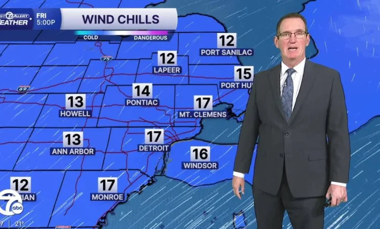
Friday: Partly sunny with highs near 25°. Winds: SW 5-15 mph. Wind chills start around zero and only reach the teens in the afternoon.
Saturday: Lots of clouds with a few flurries. Morning roads could be a little slick if we get some light snow Friday night. Highs will be in the low 30s wit 34° in Detroit. Winds: SW 10-20 mph.
Connect with 7 First Alert Meteorologists on Facebook and X:
Facebook: Dave Rexroth , Hally Vogel, Marisa Woloszyn, Mike Taylor
X: Dave Rexroth , Hally Vogel, Marisa Woloszyn, Mike Taylor
- Humidity: 66%
- Dew point: 3°
- Pressure: 30.34 in
- Wind speed: 2 mph
- Wind direction: SSE
- Visibility: 10.0 mi
- Sunrise: 07:46 AM
- Sunset: 05:00 PM