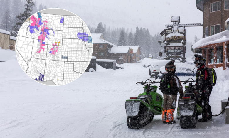
Thousands of Americans across seven states are on alert for harsh winter weather, and the National Weather Service (NWS) warns of up to three feet of snow in some places.
Urgent winter storm warnings and watches, winter weather advisories, and blizzard warnings have been issued for large portions of the United States, spanning from the Mountain West region to Alaska.
Forecasts indicate that treacherous conditions in some mountainous areas could pose significant risks to transportation, power infrastructure, and public safety.
NWS officials warn that travel could be “very difficult to impossible” in some affected areas, with some outdoor pursuits becoming “life-threatening” in certain other regions.
What Do The Warnings Mean?
According to the NWS, a winter storm warning means confidence that heavy snow, sleet, or freezing rain will cause “significant impacts”. Whereas a winter storm watch means confidence is medium for the above to happen.
Meanwhile, a winter weather advisory means that light amounts of wintry precipitation or patchy blowing snow will cause slick conditions and could make travel difficult if precautions are not taken.
An NWS blizzard warning means that, within the next 12 to 18 hours, snow and/or blowing snow is expected to reduce visibility to 1/4 mile or less for three hours or longer, and there are forecast to be sustained winds of 35 mph or greater or frequent gusts to 35 mph or greater.
Winter Storm Warnings
The NWS has issued winter storm warnings for seven states: Colorado, Utah, Alaska, Idaho, Montana, Washington, and Wyoming.
Mountain passes such as Cottonwood Pass, Rabbit Ears Pass, Teton, Togwotee, and Salt River Passes may see snow totals ranging from one foot up to three feet in isolated locations, compounded by winds up to 65 mph, leading to reduced visibility.
Colorado
The Central Mountains (Aspen, Vail, Leadville areas): forecast to get between 6–12 inches of snow, with an NWS winter storm warning impacting the area from 11 p.m. MST Friday—11 p.m. MST Saturday. The NWS warns that 35-65mph winds will hit Mountain passes (e.g., Vail Pass, Monarch), which could be snowpacked with low visibility. Travel will be very difficult. The NWS says avoid mountain travel during the storm or use extreme caution with chains and winter emergency kits.
Northern Mountains (Rocky Mt. NP, Summit County): 7-14 inches of snow predicted, with an NWS winter storm warning impacting the area from 11 p.m. MST Friday—11 p.m. MST Saturday. Gusts of up to 55 mph are likely, with blowing snow likely, meaning roads (e.g. Trail Ridge Rd., I-70) may close or become impassable. The NWS advises strongly considering altering travel plans Friday night through Saturday. If you must travel, expect road closures and carry an emergency kit.
NW Colorado (Rabbit Ears Pass, Flat Tops): Up to 20 inches of snow forecast, with an NWS winter storm warning impacting the area from 11 p.m. MST Thursday—11 p.m. MST Saturday. Gusts of 45-55 mph and near-blizzard conditions will develop Friday night into Saturday, making Rabbit Ears Pass very dangerous or impassable. NWS advises delay or avoid travel in this area. If driving is essential, use chains and carry a winter survival kit.
Idaho
Southeast Mountains (SE Idaho): between 10-18 inches of snow forecast in mountainous regions, with an NWS warning in effect from Thursday evening through to Saturday 5 a.m. MST. Some roads may become impassable, and the NWS advises avoiding mountain travel during peak storm. If you must travel, expect delays and carry emergency supplies.
Northern Panhandle (Idaho/Montana border): up to 12 inches of snow forecast, with an NWS winter storm warning in force from Thursday through Saturday, 4 pm PST. Roads will be snow-covered and slick, the NWS warns, telling people to expect winter driving conditions, check pass conditions, and be prepared for travel delays.
Alaska
Skagway & Klondike Hwy (AK Panhandle): up to 26 inches of snow forecast, with an NWS warning in force from 10 p.m. Friday to 3 p.m. Sunday AKST. Gusts of up to 45 mph are expected, which could bring down tree branches. The NWS advises avoiding non-emergency travel. If driving, carry emergency supplies.
Haines & Haines Hwy (AK Panhandle): up to 19 inches of snow forecast, with an official winter storm warning in place from 3 a.m. Saturday until 3 p.m. Sunday AKST. Gusts of up to 45 mph could cause possible tree damage. The NWS advises postponing travel unless essential. Prepare property and have supplies if you must travel.
Montana
Central & SW Mountains: up to 15 inches of snow predicted, with a storm warning in place through Saturday afternoon MST. Significant snow in ranges like the Little/Big Belt, Bridger, Madison, and Beaverhead Mountains. Passes (e.g. Bozeman Pass, Kings Hill, Chief Joseph) will be snowpacked; chains or four-wheel drive may be needed.
Western Montana (Bitterroot & Seeley/Swan): up to 15 inches of snow forecast, with a warning in place until Saturday afternoon MST. Steady snow is likely in valleys and heavy snow over passes (Lolo Pass, Lost Trail, Lookout Pass). Travel will be difficult, especially on US-93 and I-90 corridors. The NWS says use caution on mountain roads and consider postponing travel until conditions improve.
South-Central Mountains: up to 24 inches of snow forecast, with a warning active until 2 p.m. MST Saturday. Heavy snowfall is likely in the Absaroka, Beartooth, and Crazy Mountains. Backcountry conditions will be dangerous with possible whiteouts. The NWS advises being prepared for winter weather in backcountry travel during the storm. If outdoors, be prepared for deep snow and life-threatening winter conditions.
Utah
Wasatch Mountains (N. Utah): 1-3 feet of snow has been forecast, with an NWS warning in force until Sunday, 5 a.m. MST. Major snowfall is forecast in the Wasatch Range (including the Cottonwood Canyons and Bear River Range). Mountain roads will become very difficult or closed; traction restrictions are likely.
Uinta & Central Mountains: up to 2 feet of snow predicted, with an NWS winter storm warning in place until Sunday, 5 a.m. MST. Heavy snow is likely in the western Uinta Mountains and Wasatch Plateau/Book Cliffs. Routes like Soldier Summit will be snowpacked and hazardous. The NWS says to expect long delays or closures on mountain passes. Travel with an emergency kit if you must drive through these areas.
Wasatch Back Valleys: up to 16 inches of snow forecast, with a winter storm warning in force until Sunday 5 a.m. MST. Significant snowfall likely in high valleys (Park City, Heber City). 2–6 inches possible even on lower valley floors. Snow will impact the Friday morning and evening commutes in these areas.
Wyoming
South Wyoming (Snowy & Sierra Madre Ranges): winter storm warning in force from Thursday 11 p.m. MST until Sunday 5 a.m. MST, with 1–2 feet of snow forecast. Blizzard-like conditions expected in the south Wyoming mountains. Frostbite and hypothermia can develop quickly. Outdoor recreation will be life-threatening if unprepared.
NW Wyoming (Teton & Salt River Ranges): warning in force until Saturday, 2 p.m. MST. Up to 20 inches of snow forecast with gusts of up to 45 mph. Very heavy snow in the northwestern Wyoming ranges (Teton, Gros Ventre, Wyoming Range). Mountain passes (Teton Pass, Togwotee Pass) will be snowpacked with poor visibility. Travel over these passes on Friday and Saturday is highly discouraged. If you must drive, expect road closures and carry chains, warm clothing, and emergency supplies.
Winter Storm Watches
Winter storm watches are in effect across parts of Alaska and Montana, signaling the potential for heavy snow, strong winds, and dangerous travel conditions.
In Alaska, areas like the Kuskokwim Delta Coast, Nunivak Island, and Yakutat could see blizzard conditions and significant snowfall starting Saturday, with visibility dropping to near zero and wind gusts reaching up to 60 mph.
Montana’s northern regions, including the Continental Divide and Glacier Park, are bracing for up to 25 inches of snow and gusty winds, which may severely impact travel through mountain passes.
Winter Weather Advisories
Winter weather advisories span a wide swath of the country, from the Pacific Northwest to the Mid-Atlantic and Southeast.
These advisories warn of lighter but still impactful snow accumulations—typically ranging from 1 to 6 inches—along with freezing rain and gusty winds.
States like Colorado, Idaho, Utah, Kentucky, Virginia, and North Carolina are experiencing slick roads, reduced visibility, and hazardous commutes.
Even areas with minimal snowfall are facing icy conditions, prompting officials to urge caution and recommend delaying travel where possible.
Blizzard Warnings
Blizzard warnings are concentrated in Alaska’s interior, particularly along the Dalton Highway and Eastern Alaska Range.
These regions are expected to endure prolonged periods of blowing snow, extreme wind chills as low as -60°F, and near-whiteout conditions from Friday night through early next week.
The combination of strong winds and frigid temperatures poses serious risks to travelers and outdoor workers, with authorities advising that travel be restricted to emergencies and that individuals carry winter survival kits if venturing out.