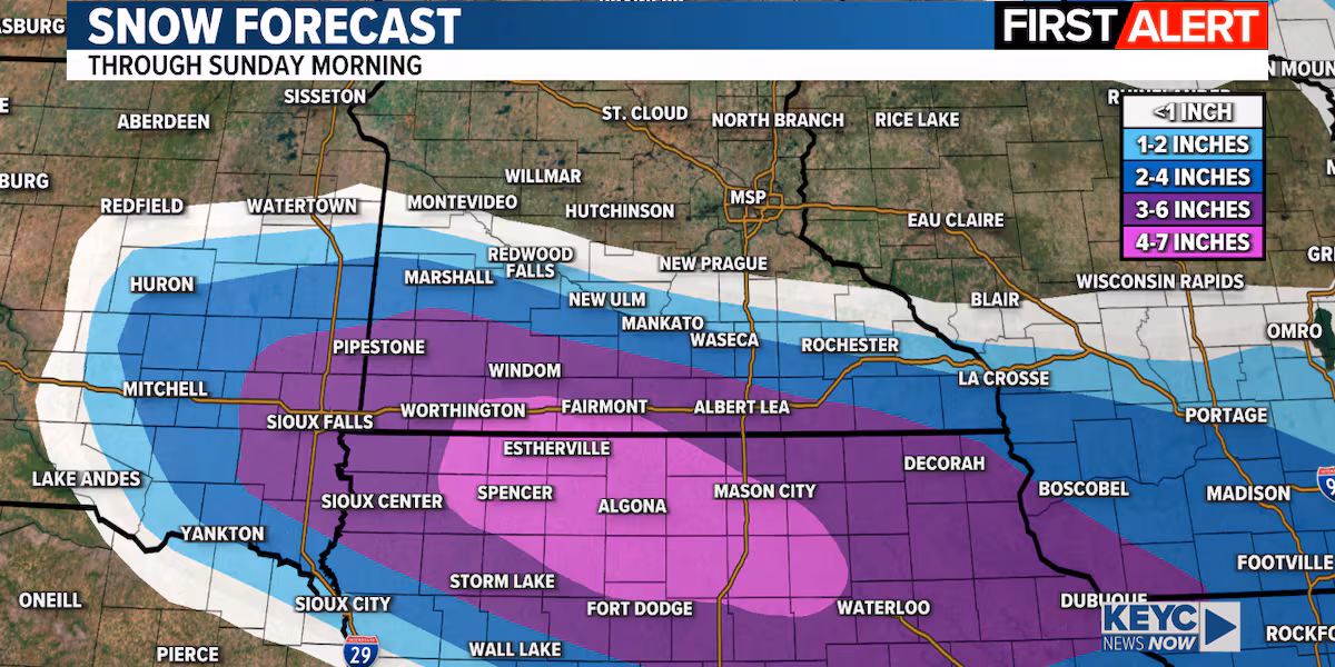
Saturday is a first alert day as we continue to track a system that will bring several inches of snow to southern Minnesota and northern Iowa later today and tonight. We’ll start with a little sunshine, but clouds will increase as snow develops by late this morning into early afternoon with light to moderate snow continuing late Saturday afternoon through Saturday evening. Snowfall amounts of 2 to 4 inches will be possible in the Mankato / North Mankato area with heavier amounts of 3 to 6+ inches across far southern and southwestern Minnesota and northern Iowa. Amounts will be lighter to the northeast. Wind will be in the 10 to 20 mph ballpark, so this will not be a raging blizzard, however there could be some issues with visibility, especially while snow is falling late this afternoon into this evening. Snow will end from northwest to southeast late Saturday night with conditions improving Sunday.
As of right now, I’m still expecting around 2 to 4 inches in the Mankato area, however, as you can see on the snow forecast map there will be a very sharp cutoff from south to north. If the system tightens up a bit more or shifts even a few miles, those expected totals will change. So stay tuned for updates throughout the day.
KEYC First Alert 10 Day Forecast
Watches, Warnings and Advisories
This image updates in real time as information changes.
KEYC Weather(KEYC Weather)
After this system exits later tonight, a couple more systems will move across the region late Sunday night into Monday and late Monday into Tuesday. Those systems will focus more to our east across northern Minnesota into central Wisconsin, but we could still get a dusting of snow with each of those with a half inch or a little more possible further east closer to the Twin Cities.
We are watching yet another system that will move across the region late Tuesday into Wednesday that will have the potential to bring areas of freezing rain and/or drizzle followed by measurable snow. It’s still way too early to pin down snowfall amounts or the exact track of this one, but it’s starting to look more and more likely that there will be some weather related travel impacts late Tuesday through Wednesday morning.
While none of these systems is a major winter storm, it will all add up with several inches of accumulation possible by the time we make our way through next week. Keep your KEYC First Alert Weather app handy. The weather team is watching everything very closely and will have updates along th
Click here to download the KEYC News Now app or our KEYC First Alert weather app.
Copyright 2025 KEYC. All rights reserved.