CLEVELAND, Ohio (WOIO) – After a relatively quiet weather day, outside of a few flurries near the lakeshore early Saturday, we are trending towards a quiet period of weather tonight before our next weather maker arrives Sunday.
Southwest winds that have brought in temperatures to the lower 30s over a snowpack has led to some haziness across parts of Northeast Ohio this evening. This is due to the snowpack starting to slowly evaporate adding a bit more moisture to our atmosphere, but locked in under the blanket of clouds.
We will not see a significant drop in temperatures tonight with lows anticipated into the upper 20s.
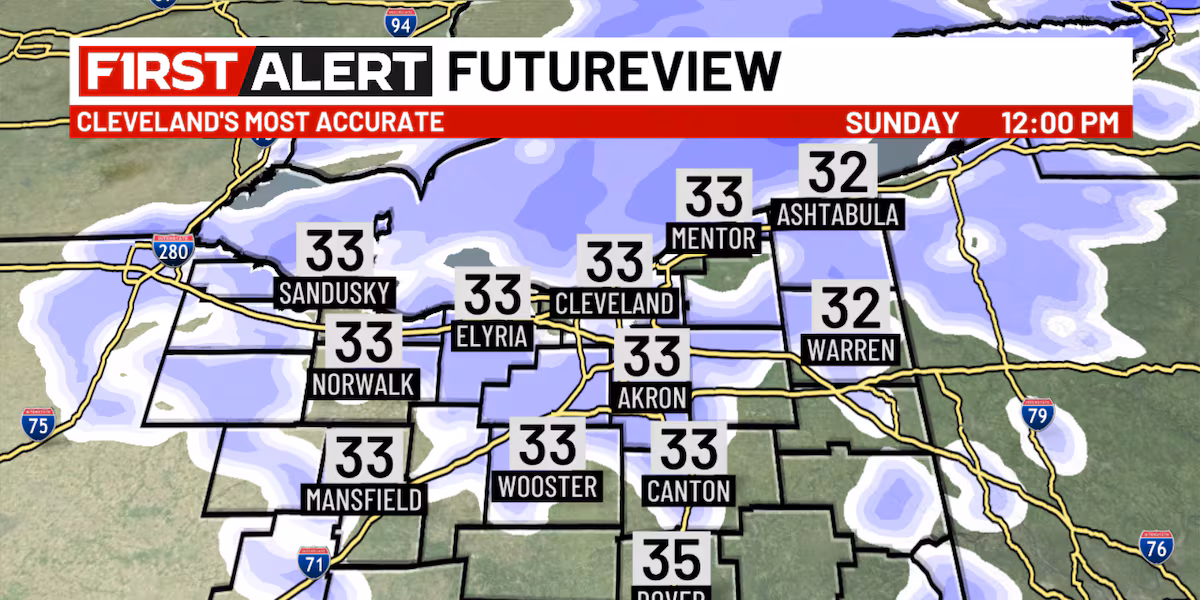
Clouds will stick around into Sunday as our next snow system arrives from the west. Highs on Sunday will warm at best into the lower to middle 30s.
Snow showers will gradually become more widespread through the morning, especially across our northern zones. This could reduce visibility at times if traveling across the area and lead to light accumulations.
Snow will stick around through the afternoon before drier air starts to spill in from the north to help bring an end to this burst of system snow. Accumulations right now are anticipated around 1″ or less. Isolated spots near the lakeshore could see up to 2″ with a little lake enhancement.
A few lake effect snow showers will be possible Sunday night before our snow chances come to a close briefly to start the upcoming work week.
Monday is a break between systems. Partly cloudy skies and highs into the upper 20s are in the forecast to begin the week. With the snowpack in place and some breaks still holding in the clouds, low temperatures Monday night look to bottom out into the lower teens.
Clouds will increase into Tuesday ahead of our next clipper system. This will briefly dive in from the north. Scattered snow showers will be possible with high temperatures warming from the teens in the morning to the low 30s by Tuesday evening.
This temperature will just continue to warm Tuesday night into Wednesday where highs are expected into the mid to upper 30s Wednesday afternoon.
The warmer air comes in with yet another storm system which will change any snow Tuesday night to a wintry mix Wednesday to possibly a cold rain at times through the day before cold air spills in Wednesday evening to transition everything back over to snow.
This is a very dynamic system which will lead to gusty conditions Tuesday and Wednesday. Gusts upwards of 40 mph will be possible.
Once the cold air spills into Northeast Ohio Wednesday night, it will be hard to see a significant temperature recovery through the end of the week and into next weekend. In fact, we will have another shot of arctic air possible by the weekend.
This cold air teamed up with a northwest to westerly steering wind, will keep some chances for lake effect snow around the area Thursday and Friday.
Some guidance wants to bring another late week clipper system through the region, though there still remains a bit of variability on the exact track of it which for us would mean the difference between a light system snow to just more lake effect activity.
As the arctic air arrives next weekend, we may see another shot at system snow securing this active weather pattern through mid-December.
Copyright 2025 WOIO. All rights reserved.


