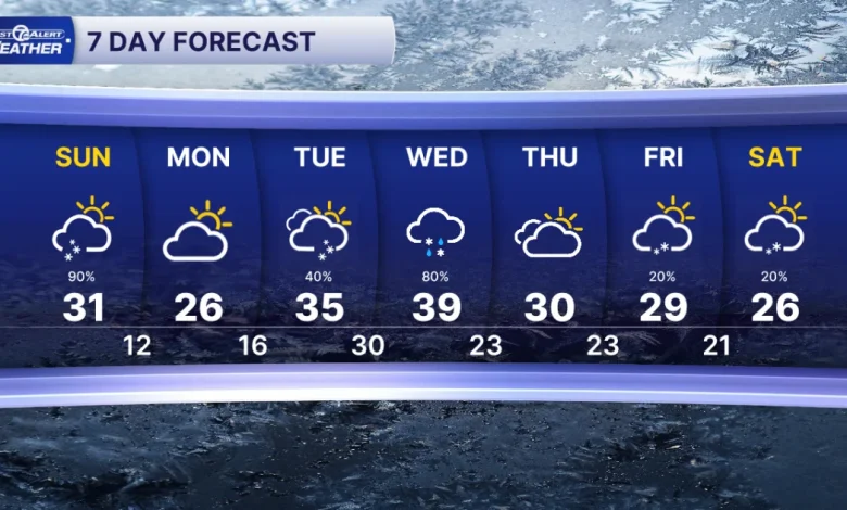
(WXYZ) — Light snow showers move in early Sunday morning and continue through midday. Snow will begin around 5 a.m. west of US-23 and gradually move east, the last showers will end around Noon Sunday. Snowfall will be around 1″, with lighter amounts near 1/2″ farther east and up to 2″ farther west. High temperatures climb to near 31°.
7 First Alert Weather
Snowfall forecast for Sunday, December 7.
Sunday’s snow is the first of many chances this upcoming week for snow, as a series of systems pass through. The next best chance for accumulating snow will be Tuesday into Wednesday. Depending on the track of this system, some rain is also likely, mainly south of I-96 at this time. Another chance for snow arrives Friday into Saturday. Temperatures will rise and then fall this week. Highs temperatures will be in the mid 20s Monday, mid 30s Tuesday, near 40° Wednesday, near 30° Thursday, and in the upper 20s Friday.
Tonight: Cloudy. Lows in the low 20s. Winds: Light
Sunday: Snow early through midday. Highs near 31°. Winds: WNW 5-10 mph.
Monday: Partly sunny. Highs in the mid 20s. Winds: ENE 5 mph.
Connect with 7 First Alert Meteorologists on Facebook and X:
Facebook: Dave Rexroth , Hally Vogel, Marisa Woloszyn, Mike Taylor
X: Dave Rexroth , Hally Vogel, Marisa Woloszyn, Mike Taylor
- Humidity: 70%
- Dew point: 21°
- Pressure: 30.06 in
- Wind speed: 6 mph
- Wind direction: W
- Visibility: 10.0 mi
- Sunrise: 07:48 AM
- Sunset: 05:00 PM