A quick-hitting system Monday brings the potential for light
snow accumulation in parts of the area.
Let’s walk you through the timing, totals, impacts and
caveats.
As it stands right now, this is a light event. However, if low pressure strengthens off the coast, that could pull cooler air down and up totals a bit.
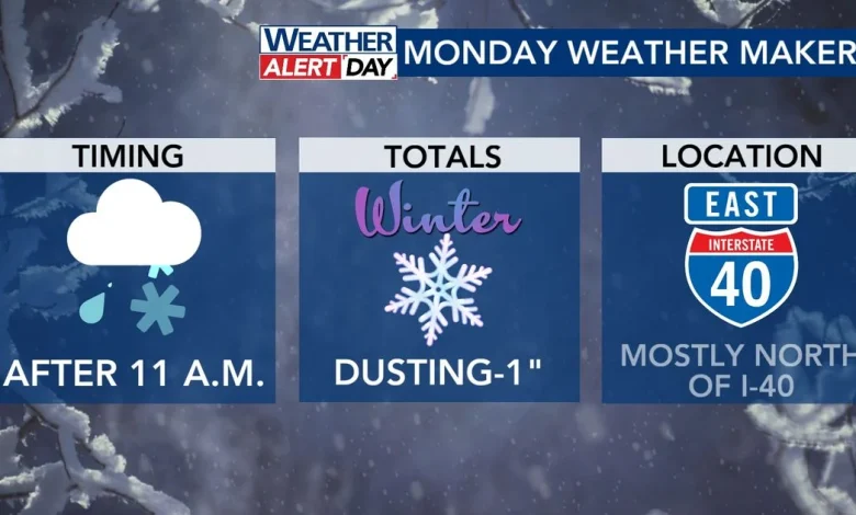
Timing
If you’re expecting to wake up to a winter wonderland Monday
morning, you’re going to be disappointed.
Precipitation starts in Person, Orange and Chatham counties
after 9 or 10 a.m. and then gradually spreads east from there.
As it does so, it likely starts as rain or a rain/snow mix
in the Triangle and areas near I-40.
The air cools into the afternoon, changing things to all
snow. This could perhaps go as far south as areas like Lillington, Smithfield
and Wilson.
However, it’s highly unlikely that we see anything as far
south as Clinton.
Totals
Totals are higher where it stays colder longer. That means
folks north of I-85 and closer to the Virginia state line could get a dusting to an inch.
There’s even the chance at lakes as small as Kerr Lake and Lake Gaston enhance a band of snow or two.
The farther south you go, the totals you see are entirely contingent on
whether or not the snow falls heavily enough to overcome the “warm” ground.
Temperatures during the day will likely be between 34 and 37° south of I-85.
If the snow falls heavily enough, then yes, you’d exceed “a dusting.”
However, anything that falls lightly onto that “warm” ground either melts or results in a dusting on elevated surfaces.
Roads, schools, etc.
Forecasting weather is hard enough. Forecasting what schools, businesses, etc. will do in a borderline system like this is nearly impossible.
(That’s not a knock on those folks! They have a tough job.)
That said, any little bit of moisture that’s left laying will likely freeze Tuesday morning. That doesn’t matter if it’s one inch, half-an-inch, a quarter-of-an-inch.