Kansas City will get a break from the bitter cold over the next couple of days before a storm system that will mostly miss the metro brings slight chances of rain, the forecast shows.
According to the National Weather Service, Friday morning’s wind chill values are in the single digits and teens. But temperatures will rise to the mid 30s to mid 40s by the afternoon.
Friday is expected to be a cloudy day with a high temperature near 43 degrees. A southwest wind will make it feel cooler, and gusts up to 20 miles per hour are possible, the forecast shows.
A storm system moving north will likely pass the metro Saturday, keeping rain and snow chances minimal, according to the weather service.
Kansas City weekend forecast
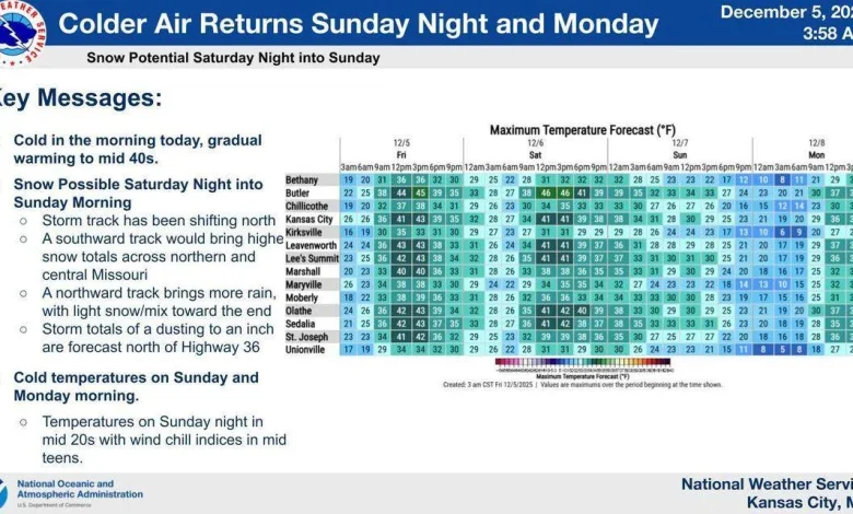
A dusting to an inch of snow is forecast Saturday night for areas north of Highway 36 in Missouri, the weather service said. For areas south of Highway 36 and the Kansas City metro, rain may form into a wintry mix, but no accumulation is expected.
Weather models show a storm track headed for Missouri is shifting north. A track that stays on the northern course would bring more rain with light snow mix toward the end. A southern track would bring higher snow totals across northern and central Missouri, the weather service said.
Warmer air will give Kansas City a break from frigid temperatures Friday and Saturday, when the high temperature could reach the low 40s, the forecast shows.
Saturday’s high temperature is expected to be near 42 degrees with calm wind coming from the southwest in the afternoon. Overnight Saturday into Sunday morning, the low temperature is forecast around 26 degrees.
But it won’t be long before cold air returns to Kansas City.
Sunday’s high temperature is forecast around 31 degrees. Stronger north winds around 8 to 11 mph will make it feel colder. Wind gusts up to 21 mph are possible.
Overnight Sunday and into Monday morning, the weather service said wind chill values will be in the mid-teens.