UK Christmas snow forecast as 3 snowstorms could hit half of Britain before festive period
Advanced weather forecasting maps indicate that up to three snowstorms could sweep across the UK in the days leading up to Christmas, potentially resulting in a white Christmas.
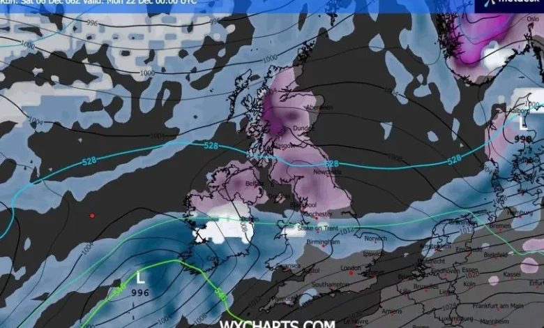
The GFS weather model suggests that approximately half of the country could be affected by this Arctic blast, with several inches of snow anticipated in some areas.
The wintry disruption is predicted to commence on December 20, as an Atlantic weather front brings both snow and rain across the UK. Northern Ireland appears set to experience the most intense snowfall initially, before Wales, the Midlands, northern England and Scotland also see some snowflakes.
The second snowstorm is forecasted to strike Northern Ireland at 6am on December 21, potentially delivering 1cm of snow per hour. This snow is then expected to drift over the rest of the UK, with the north-west of England likely to see the heaviest snowfall.
-Credit:WX Charts
Remarkably, weather maps for December 22 depict a third snowy front depositing several centimetres of snow in Northern Ireland, northern England and Scotland. It remains uncertain whether temperatures will stay low enough for the snow to persist on the ground until Christmas Day, reports the Mirror.
Snow coverage maps for December 22 reveal snow settled on the ground across roughly half of the UK, covering nearly every region above Manchester. The data indicates that up to 12cm (approximately five inches) could settle in the north of Scotland, with 6cm possible in some parts of northern England and Northern Ireland.
Met Office Christmas weather forecast
The Met Office’s latest predictions hint at the possibility of snowfall towards the end of December. Their forecast for 20th December to 3rd January reads: “Changeable conditions are expected across the UK during this period.
“Low pressure systems will probably dominate, meaning showers or longer spells of rain, heavy at times, for much of the UK and some hill snow in the north.
“Periods of strong wind are also possible, especially around coasts. Some drier, more settled spells are possible but how long these last is very uncertain. Temperatures will likely be close to average or slightly above overall.”
BBC Christmas weather forecast
BBC Weather’s forecast for 22nd December to 4th January states: “From the Christmas period through to the New Year, there is a high degree of uncertainty. However, the positive NAO pattern is most likely to continue for a while. As such, the most probable outcome is for further changeable weather, with occasional rain or showers and periods of strong winds.
“This should also mean that mostly mild conditions should prevail. A few brief colder intervals are possible, but any snow should still be confined mainly to northern uplands.
“Having said that, there are some hints that the pattern could change by January, with indications that the NAO may switch from positive to negative.
“In other words, we could see high pressure starting to develop in the vicinity of Iceland and Greenland instead of low pressure. If that were to occur then we could see a change in weather type, with a growing chance of colder weather.
“The situation is complicated by disturbances in the upper atmosphere that might have an impact on the northern hemisphere’s circulation in three to four weeks time.”