Winter storm warning affecting Southern Erie until early Friday morning – winds gusting up to 35 mph
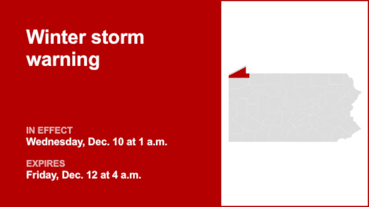
On Wednesday at 12:45 a.m. a winter storm warning was issued by the National Weather Service valid from 1 a.m. until Friday 4 a.m. for Southern Erie.
“Total snow accumulations 8 to 10 inches. Locally higher amounts up to 14 inches within the most persistent lake effect snow bands. Winds gusting as high as 35 mph,” can be expected according to the weather service. “An initial period of snow is expected late tonight into early Wednesday, with peak snow rates of up to 1 inch per hour. After a break in the snow most of the day Wednesday, a period of snow and falling temperatures is expected Wednesday evening. Lake effect snow develops overnight Wednesday night and persists through Thursday night.”
“Roads, and especially bridges and overpasses, will likely become slick and hazardous. Travel could be very difficult to impossible. The hazardous conditions could impact the Wednesday morning and evening commutes,” explains the weather service. “If you must travel, keep an extra flashlight, food, and water in your vehicle in case of an emergency. The Pennsylvania Department of Transportation and Pennsylvania Turnpike Commission strongly encourage motorists to heed all travel restrictions and delay unnecessary travel. Persons should consider delaying all travel. If travel is absolutely necessary, drive with extreme caution. Consider taking a winter storm kit along with you, including such items as tire chains, booster cables, flashlight, shovel, blankets and extra clothing. Also take water, a first aid kit, and anything else that would help you survive in case you become stranded.”
Staying safe on winter roads: Winter driving tips from the weather service
Winter weather can make driving treacherous, leading to over 6,000 weather-related vehicle fatalities and over 480,000 injuries each year. When traveling during snow or freezing rain, prioritize safety by slowing down. In near-freezing temperatures, it’s safest to assume that icy conditions exist on roadways and adjust your driving accordingly. Be cautious of ice accumulating on power lines or tree branches, which can lead to snapping and falling hazards. If possible, avoid driving in such conditions. If you must venture out, opt for routes with fewer trees and power lines. Never touch a downed power line, and immediately dial 911 if you come across one. Here are additional winter driving tips from the weather service:
Share your travel plans:
When venturing out of town in hazardous winter weather, be sure to inform family or friends of your destination, your intended route, and your estimated arrival time.
Prepare your vehicle:
Ensure your gas tank is full and equip your vehicle with essential winter supplies, including a windshield scraper, jumper cables, a small shovel, flashlight, cell phone, blanket, extra warm clothing, drinking water, and high-calorie non-perishable food.
Stay calm when stranded:
If you become stranded, stay composed. Notify someone about your situation and location. Avoid attempting to walk to safety. Attach a cloth to your car’s antenna or mirror to signal that you require assistance. Make your vehicle more visible by using the dome light and flashers.
Be mindful of snow plows:
Keep an eye out for snow plows and allow them ample room to pass. Only overtake a plow when you have a clear view of the road ahead.
Check road conditions:
Before embarking on your journey, verify the current road conditions to make informed travel decisions.
These winter driving tips from the weather service are your key to a safer journey on snow-covered roads. By following these guidelines, you can significantly reduce the risk of accidents and ensure your well-being during challenging winter weather.