Met Éireann have upgraded Cork and Kerry to Status Orange
08:50, 13 Dec 2025
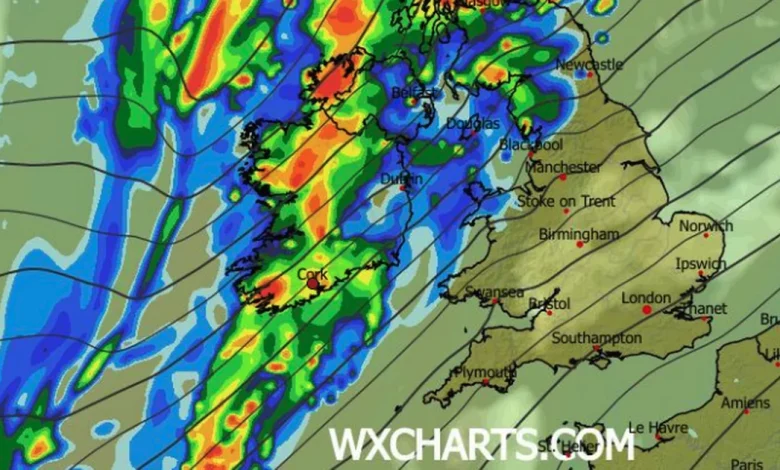
(Image: WXCharts)
We’re getting ready for a very wet and wild weekend as widespread heavy rain triggers weather warnings across Ireland. Met Éireann has upgraded the warning for Cork and Kerry to a Status Orange from the early hours tonight, with signigicant rain fall likely across West Cork and Kerry in particular.
A number of counties are on a 30-hour weather alert from Saturday evening as rolling rainstorms lash into the west for the weekend, with Met Éireann giving plenty of forewarning to expect flooding across Munster as rain falls on already sogged soil after Storm Bram earlier this week.
The weather warnings this weekend are:
- Saturday – Cork, Kerry, Limerick, Clare, Donegal and all of Connacht are on a Status Yellow alert from 6pm this evening with an increased flood risk warning due to high river levels and saturated ground. The warning is in place through Saturday night and Sunday until midnight as the national forecaster urges caution over river and surface flooding, difficult travelling conditions and poor visibility.
- Tipperary, Waterford, and Wexford will be on Status Yellow from midnight tonight until 3am in the early hours of Monday, as rain lashes in for hours on Sunday.
- Sunday – Cork and Kerry are on Status Orange from 3am to 6pm Sunday with significant rainfall accumulations, especially on high ground, with the highest totals expected in Kerry and West Cork.
Updating its regional forecast for Munster this morning ahead of a weekend of lashing rain, Met Éireann said that after Storm Bram brought Status Orange level storms earlier this week, river and surface water flooding are very likely due to high river levels and saturated soils. We can also expect fresh to strong and gusty southwesterly winds, and Met Éireann has advised people to keep an eye on updates to the forecast ahead of what could be a pretty nasty bout of wet and windy weather this weekend.
Before then, Saturday daytime shouldn’t be too bad, with some hazy sunny spells at times before heay outbreaks of rain move in to the southwest later this evening.
Here’s the latest for Cork and Munster:
Today – A dry start today with hazy sunny spells. Cloud will build from the west through the morning, bringing outbreaks of rain through the afternoon. The rain will turn heavier in the southwest parts later in the evening. Becoming windier with southerly winds increasing fresh to strong and gusty. Highest afternoon temperatures of 8 to 11 degrees. Wet and blustery tonight with widespread outbreaks of rain and drizzle. The rain will be heavy at times, particularly towards the morning. Mild with lowest temperatures of 10 to 12 degrees with fresh to strong and gusty southwesterly winds.
Tomorrow – Continuing wet and blustery across the country on Sunday, with widespread outbreaks of rain, turning heavy at times. With high river levels and saturated soils, river and surface water flooding are likely. Highest temperatures of 11 to 13 degrees with fresh to strong and gusty southwesterly winds. Widespread rain will gradually clear southeastwards overnight, with clear spells and just isolated showers following from the west. Rain is likely to linger over parts of the southeast. Lowest temperatures of 4 to 7 degrees with winds veering southwest to west and easing mostly light.
Monday: Mostly dry and bright with sunny spells developing and scattered showers, mainly in parts of the west. Remaining cloudy with rain for a time in the far southeast, clearing through the morning. Highest temperatures of 8 to 11 degrees with mostly light southwest to west winds. Overnight, it should be dry with long clear spells developing, and just some light showers along Atlantic coasts. Lowest temperatures of 0 to 4 degrees with light southwesterly winds, allowing some frost to form as well as patches of mist and fog. Tuesday: Dry and bright with good spells of sunshine and just the odd light shower possible in Atlantic coastal counties. Highest temperatures of 5 to 9 degrees with light southwesterly winds. Wednesday: Wet and blustery to start with a spell of rain moving eastwards through the morning, likely clearing to scattered showers through the afternoon. Highest temperatures of 10 to 13 degrees with fresh to strong southwesterly winds. Further outlook: The drier and brighter conditions for the early days of next week will give way to further spells of wet and blustery weather from midweek onwards. Current indications show a further spell of wet and blustery weather on Thursday with a continuation of unsettled weather likely for the rest of the week