N.J. weather: Widespread snow totals of 2 to 5 inches expected tonight. Latest forecast maps.
A winter storm will dump 3 to 5 inches of snow across a wide area of New Jersey tonight into Sunday morning with some locally higher amounts possible, according to the latest forecast.
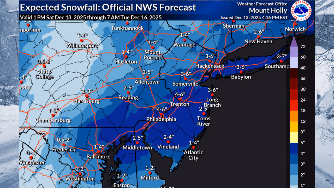
“A total of 1-5 inches of snow across the whole area,” the National Weather Service said Saturday evening. “There could be a zone of 5+ inches near I-95 into southern N.J.”
The storm will be the first widespread snow for New Jersey this season.
Most of New Jersey can expect to get hit by 2 to 5 inches of snow tonight into early Sunday with some locally higher amounts possible near the I-95 corridor. Wind gusts will increase Sunday after the storm with dangerously cold wind chills expected.National Weather Service
A winter storm warning has been issued for Camden, Gloucester and northwestern Burlington Counties, where 3 to 5 inches or more is forecast.
The warning runs from 7 p.m Saturday to 1 p.m. Sunday.
The rest of the state is under lesser winter weather advisories.
Most of New Jersey can expect to get hit by 2 to 5 inches of snow tonight into early Sunday with some locally higher amounts possible near the I-95 corridor. Wind gusts will increase Sunday after the storm with dangerously cold wind chills expected.National Weather Service
Snow is expected to start across western portions of the state by mid-evening Saturday, potentially starting as light rain or a rain-snow mix before changing to all snow as temperatures drop.
The changeover to all snow should occur by midnight near and northwest of I-95, with the rain-snow line progressing southeastward through the overnight hours.
Most of New Jersey can expect to get hit by 2 to 5 inches of snow tonight into early Sunday with some locally higher amounts possible near the I-95 corridor. Wind gusts will increase Sunday after the storm with dangerously cold wind chills expected.National Weather Service
The heaviest snowfall is anticipated during the pre-dawn hours Sunday, with snowfall rates potentially reaching 1 inch per hour in central and southern New Jersey.
This period of heavy snow, though lasting only a few hours, will create substantial accumulations and hazardous travel conditions.
Snow will taper off from west to east by Sunday afternoon, but temperatures will remain very cold throughout the day.
Highs will only reach the low 30s for southeastern areas and 20s northwest of I-95.
Many locations will see their high temperatures early in the day before falling through the afternoon.
Most of New Jersey can expect to get hit by 2 to 5 inches of snow tonight into early Sunday with some locally higher amounts possible near the I-95 corridor. Wind gusts will increase Sunday after the storm with dangerously cold wind chills expected.National Weather Service
Winds will increase as the snow ends, with gusts of 25 to 35 mph expected.
The combination of very cold air and breezy conditions will lead to wind chills in the single digits to low teens across the entire state by sunset. Areas of blowing snow are possible.
Sunday night into Monday morning will feature the coldest temperatures of the season falling into the lower to mid teens and wind chills ranging from zero to 5 degrees.
Most of New Jersey can expect to get hit by 2 to 5 inches of snow tonight into early Sunday with some locally higher amounts possible near the I-95 corridor. Wind gusts will increase Sunday after the storm with dangerously cold wind chills expected.National Weather Service
Winds will continue to gusts up to 35 mph Sunday night.
Monday will remain dry with decreasing winds, though highs will only reach the low to mid 30s for most areas.
An Arctic airmass will persist through Tuesday, with overnight lows Monday night in the teens for many locations.
Tuesday will be another cold day with highs in the mid 20s to mid 30s.
The weather pattern begins to change Wednesday with highs in the upper 30s to upper 40s and the potential for rain on Thursday with highs in the upper 40s and upper 50s.