CLEVELAND, Ohio — One more frigid day stands between Northeast Ohio and a brief warmup that will bring the region its first above-average temperatures since the day before Thanksgiving.
Cold, gray weather will remain in control across the region on Monday, with lingering lake-effect snow bringing minor accumulations to parts of the snowbelt before conditions gradually quiet down after a snow-filled weekend.
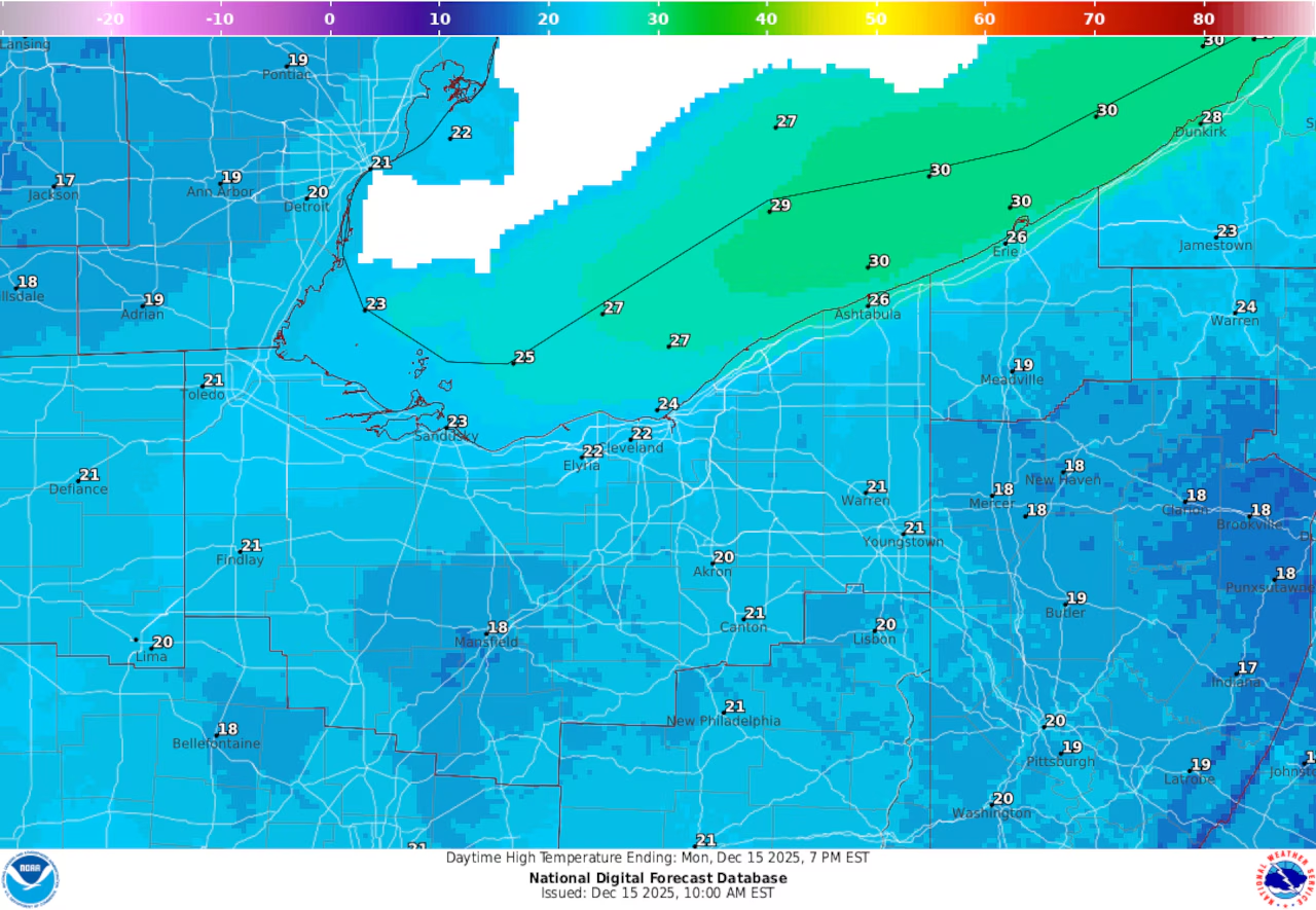
The periods of light snow continue early Monday in far northeastern Ohio, especially eastern Cuyahoga, Lake, Geauga and Ashtabula counties, where an additional inch or two of accumulation is possible through the evening, according to the National Weather Service in Cleveland.
Lake-effect snow showers could bring some minor accumulations to far Northeast Ohio on Monday, Dec. 15, 2025.Courtesy National Weather Service
While snowfall rates are expected to remain light, brief coatings of snow are possible on untreated roads, particularly in the snowbelt.
Elsewhere across Northeast Ohio, conditions will stay mostly dry, though skies remain mostly cloudy and temperatures will remain well below normal. Afternoon highs will struggle to climb out of the upper teens to lower 20s.
Lake-effect snow will gradually shift east and weaken later Monday as winds turn more southwesterly. Any lingering snow showers should wind down overnight, with little additional accumulation expected. Lows across the region will be in the low to mid teens.
Milder Tuesday brings break from deep freeze
Skies will turn sunnier early Tuesday before clouds increase later in the day as winds turn breezy from the southwest. Temperatures will climb into the mid 30s — a noticeable step up from recent days and enough to push most of Northeast Ohio above freezing during the afternoon.
Dry weather is expected to hold through the day and into Tuesday night as high pressure slides east, keeping travel impacts minimal ahead of a more active pattern later in the week.
Windy, wet storm brings first above-average temperatures in weeks
Look at those temperatures! Highs on Thursday are expected to climb into the upper 40s across Northeast Ohio — the region’s first above-average day since the day before Thanksgiving.Courtesy National Weather Service
Northeast Ohio’s brief warmup will continue through Wednesday, with highs climbing to around 40 degrees, before peaking Thursday as the warmest day of the week.
A strong storm system is expected to move through the Great Lakes on Thursday, pushing temperatures into the upper 40s — the area’s first above-average day since Nov. 26, according to the National Weather Service.
But that warmth will come with consequences. As the system moves through, it’s expected to bring gusty winds and widespread rain on Thursday.
That rain is expected to overspread the region Thursday into early Thursday night, with rainfall totals around a half-inch likely and localized amounts approaching an inch possible. Mild temperatures and rising humidity will lead to noticeable snowmelt, though widespread river flooding is not expected.
Wind gusts could reach 35 to 40 mph, particularly during the warm, southwest flow Thursday and again along the lakeshore following a strong cold front Thursday night.
A flash freeze is possible late Thursday night as temperatures drop sharply behind the cold front, falling from the upper 40s into the low 20s by early Friday. Rain may briefly change to snow before ending, with only minor accumulation expected.
Lake-effect snow possible Friday, milder weekend ahead
Northeast Ohio will finally see some warmer temperatures later this week, but that will also mean rain.cleveland.com
Colder air pouring over Lake Erie on Friday could trigger a round of lake-effect snow, mainly in the primary snowbelt east of Cleveland. At this point, forecasters say the setup looks more like an advisory-level event rather than a major storm, with snow tapering off by Friday night as high pressure builds in.
Temperatures will rebound again this weekend, with highs climbing back into the 40s Saturday before another system brings rain late Saturday into Saturday night. High pressure is expected to return Sunday, keeping the up-and-down temperature pattern in place heading into the days before Christmas.