An urgent Flash Flood Warning was issued for areas in Kent, Renton and Tukwila after a reported failure of the Green River levee. Officials say this is potentially life-threatening.
Tap here to jump directly to the Flash Flood Warning alert and evacuation shelters in the live blog timeline.
Rain on Monday is forecast to bring another round of river flooding into Tuesday and Wednesday. Areas that previously experienced significant flooding could still see water levels rise again.
View of SR-167 impacted by flood waters at South 277th St East
Timeline:
Keep reading for live weather updates for Monday, Dec. 15.
1:44 p.m.: PSE reports nearly 20,000 power outages in western WA
As of 1:44 p.m., Puget Sound Energy is reporting 127 active outages impacting 18,393 customers.
A second major storm in just over a week is bringing heavy rain and strong winds, worsening saturated soils from recent flooding and causing power outages expected to continue Monday. PSE officials warn unstable ground could trigger landslides as crews monitor conditions and stand ready.
1:43 p.m.: Desimone Levee on Green River breached, but holding steady in Tukwila
Officials said the Desimone Levee along the Green River in Tukwila has breached, but is holding steady.
This is happening in an industrial area, no residential neighborhoods are being impacted at this time.
A Code Red Alert has gone out to all impacted properties. As part the City of Kent’s Ready-Set-Go emergency system, a Level 3 GO NOW Evacuation notice was issued for anyone in the following areas within the Kent Boundaries:
- North: Kent City Limits
- West: Green River
- South: S 200th St
- East: W Valley Highway
“Leave immediately if you are in this area. There are road closures in the area, please avoid these and any roads with standing water.”
1:20 p.m.: King County Operations to hold a press conference on regional flooding
King County will host a media briefing at 2 p.m. on Dec. 15. FOX 13 Seattle will stream the press conference live in the video player at the top of this website.
King County said the speakers will include King County Executive Girmay Zahilay, King County Sheriff Patti Cole-Tindall, King County Emergency Management Director Brendan McClusky, King County Department of Natural Resources and Parks Director John Taylor and a Seattle representative for the National Weather Service.
1:14 p.m.: American Red Cross advises evacuees to seek shelter in Auburn, WA
1:06 p.m.: Tukwila Police clarify evacuation zones
“Some of you may have received a phone notification regarding evacuation orders,” the department wrote. “In terms of the scope of it for Tukwila, it is only for the far southeast corner of the city in the industrial area S of 180th near W Valley Hwy.”
Authorities say there is no evacuation order in place for residential areas or the commercial district near the Southcenter Mall.
12:55 p.m.: City of Tukwila, WA announces GO NOW evacuations after levee breach
“The Desimone Levee has breached. This is a GO NOW evacuation for people in parts of Kent, Tukwila and Renton,” the city announced on Facebook. “In Tukwila, the GO NOW is only for that part of the City south of S. 180th Street and west of West Valley Hwy.”
Tukwila and King County have not issued an evacuation for any areas west of the Green River. However, officials are saying the situation could change and residents should be READY in case another evacuation order is issued.
12:55 p.m.: Hood Canal Bridge SR-104 closed due to high winds
Hood Canal Bridge closed due to high winds. (WSDOT)
WSDOT announced that SR-104 Hood Canal Bridge was closed to vehicle traffic due to high winds.
“The high winds are causing sprays of water to spill over the road deck on the bridge. Crews are monitoring and standing by to reopen when the winds decrease. We don’t have an estimate on when the bridge will reopen.”
WSDOT notes that weather conditions on the shore can be very different than what’s happening in the middle of the canal where there is no barrier to wind.
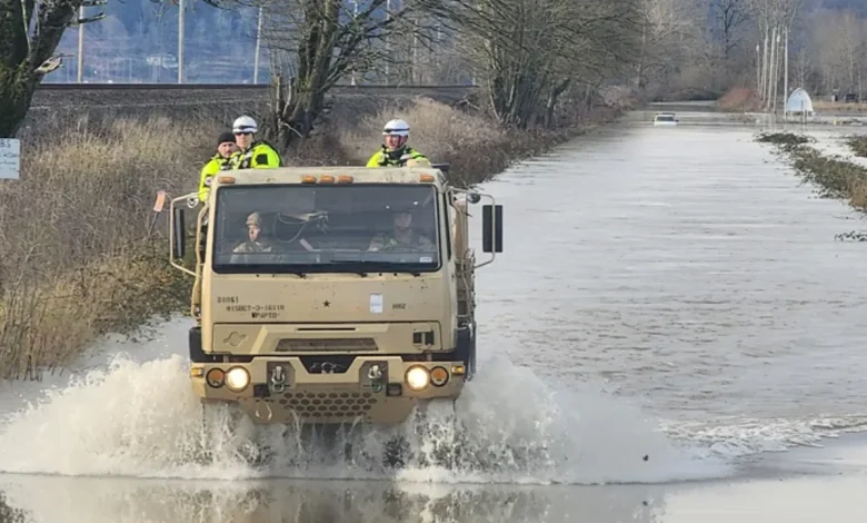
12:52 p.m.: WA National Guard moving to King County for Flash Flood Warning support
12:30 p.m.: Green River area levee breach and flooding ‘GO NOW’
The King County Office of Emergency Management on Monday released a list of places where people in the evacuation zone can seek shelter:
- Auburn Community and Event Center (910 9th St. SE, Auburn, WA)
- Ray of Hope Shelter (2806 Auburn Way N. Auburn, WA)
- Evergreen State Fairgrounds (14405 179th Ave. SE, Monroe, WA)
What they’re saying:
“This is for residents and business east of the Green River in the Orillia area in Tukwila, Renton and Kent. Due to breach in the Desimone Levee, this area is under GO NOW evacuation notice,” King County Emergency Management announced. “Leave immediately if you are in this area. Conditions are dangerous and access routes may be lost at any time. Go north or south of evacuated area away from flooding waters. Do not drive or walk through standing or moving water. Turn around, don’t drown. Do not drive around barricades or road closures. If you need emergency evacuation assistance, call 911.”
12:00 p.m.: URGENT: Flash Flood Warning issued for areas in south King County, WA
The National Weather Service of Seattle issued a Flash Flood Warning just before noon.
At 11:51 a.m., county dispatch reported the failure of the Green River levee causing flash flooding near the Green River in Tukwila.
“HAZARD… Life-threatening flash flooding from the failure of the Green River levee,” the alert said.
Other areas that will experience flash flooding include Kent, Renton and Tukwila. This includes areas near the Green River, Duwamish Waterway and Cedar River.
The NWS says the Flash Flood Warning will remain in effect until 9:00 p.m. Monday.
Why you should care:
“If you are in low-lying areas you should move to higher ground immediately,” the alert said. “Move to higher ground now. Act quickly to protect your life.”
10:30 a.m.: Lanes previously open on SR-167 are now closed again in Kent, Auburn
“Well, we tried,” announced WSDOT. “But BOTH directions of SR 167 are CLOSED again between S 212th Street (MP 22) in Kent and 15th St. NW (MP 16) in Auburn due to rising water from the Green River.”
Officials have not released an estimated time to reopen lanes or ramps along this six-mile stretch of SR-167.
10:12 a.m.: Chinook Farms destroyed by flooding in Snohomish County, WA
Last Thursday, we spoke to Eric Fritch, owner of Chinook Farms, after it was swallowed by flooding from the Snohomish River. Fritch sent FOX 13 a video he recorded from a boat on his flooded farm.
On Monday, Dec. 15, Fritch sent a couple photos of the damage left behind after the flood levels lowered. He said he has no flood insurance, so he is hoping for state and federal disaster relief funding.
9:43 a.m.: Flood Watch issued for Skagit County, WA; will remain in effect until Thursday
The U.S. National Weather Service issued a Flood Watch for Skagit County early Monday morning. Meteorologists say this will remain in effect until Thursday, Dec. 18.
“The Flood Warning for the Skagit River in Mount Vernon and Concrete is still in effect,” according to county officials. “Additionally, a Wind Advisory is in effect until 10:00 p.m. on Monday, December 15th, and a High Wind Watch will be in effect from Tuesday, December 16th through the morning of Wednesday, December 17th.”
Skagit River likely to reach major flooding stage on multiple days this week
This was just one car out of many swept away by floodwaters flowing over roads. (NWS / NOAA)
What they’re saying:
“River forecasts indicate that the Skagit River will experience major flooding on multiple days this coming week.,” announced Skagit County officials in a Monday press release. “In Concrete, the river is predicted to crest at 32.8 feet at 4:00 a.m. on Tuesday, December 16th. A second crest is expected in Concrete on Wednesday, December 17th, around 4:00 p.m., reaching 33.32 feet. In Mount Vernon, the Skagit River is expected to crest at 32.81 feet on Tuesday, December 16th, at 10:00 p.m., and then peak again at 32.89 feet on Thursday, December 18th, at 10:00 a.m. All four crests are forecast to exceed the major flooding thresholds of 32.5 feet in Concrete and 32 feet in Mount Vernon. Residents should prepare for ongoing flooding as waterways are already at capacity, and dikes and levees are under significant strain. Even if recent floodwaters did not reach your home, it’s important to remember that each flood path is different. Monitor forecasts closely and be prepared.”
9:37 a.m.: Flooding, severe-weather impacts in Leavenworth, WA
This morning on Good Day Seattle we spoke to Troy Campbell, Leavenworth’s Chamber of Commerce executive director, about canceled holiday festivities due to weather-related outages.
8:52 a.m.: City of Auburn announces updated road closures
“Please avoid these areas and plan alternate routes,” the City of Auburn announced on Facebook. “Conditions may change. Many of these road closures include northbound routes out of Auburn, including SR167 — please plan ahead and expect delays.”
Auburn Way North / North-South Routes
- Northbound Auburn Way N closed from 37th St NW to S 277th St.
- Both lanes of northbound Auburn Way N closed between 49th St NW and S 277th St.
- Detour: Westbound 49th St NW → B St NW.
- Northbound B St NW closed from 37th St NW to S 277th St.
- West Valley Hwy (northbound) closed from 37th St NW to S 277th St.
South 277th Street / East-West Routes
- S 277th St closed between Auburn Way N and 108th Ave SE (Kent).
- Frontage Rd closed at S 277th St and at I St NW / 44th St NW.
Downtown / Central Auburn
- 49th St NE closed between Auburn Way N and I St NE.
- 49th St NE closed between Auburn Way N and B St NE.
- D St NE closed between 49th St NE and S 277th St.
- I St NE closed between 49th St NE and S 277th St.
- Pike St NE closed between 8th St NE and 12th St NE.
Trail Run Neighborhood
- Trail Run (L St NE & S 277th St) is only accessible via the private gate off 52nd St NE.
Green River / Southeast Auburn
- Green River Rd SE closed from 100th Ave SE to the Auburn city limits.
- 104th Ave SE closed between Green River Rd SE and SE 320th St.
- 104th Ave SE north of 8th St SE is closed.
West Valley Highway (Landslide – not flood related)
- West Valley Hwy closed between 15th St NW and W Main St.
- Closure due to landslides and downed trees.
- Roadway will remain closed for some time while we evaluate.
State Highways
- SR167 is closed northbound. Southbound lanes opened Monday morning.
8:49 a.m.: Lane closure on eastbound I-90 near North Bend, WA due to landslide
Washington State Patrol Trooper Rick Johnson announced that the right two lanes of eastbound I-90 are closed near milepost 36 due to a landslide near the shoulder of the road.
8:27 a.m.: Meteorologist Abby Acone breaks down hot spots for landslides in WA
As we track yet another onslaught of rain this week, the local landslide threat is skyrocketing.
“It’s these types of areas that are most vulnerable to landslides,” said Acone. “It includes steep coastal bluffs, other steep hillsides or road cuts, along with recently burned areas.”
“After the destructive landslide in Oso in 2014, our state has invested millions of dollars to improve detecting these natural disasters with Lidar Data. Geologists say that identifying slides that have happened in the past is critical, because it indicates where it may happen again.”
“Washington is one of the most landslide-prone states in the country – causing tens to hundreds of millions of dollars in damage every year, according to the USGS.”
“Our recent rain totals are intense. We’ve had more than a foot of rain in the last week over the mountains – and an extra two to six inches are expected early this week.”
“The landslides hazards program at the Washington Geological Survey has identified tens of thousands of landslides since 2014.”
Here’s where you can pinpoint the areas with heightened risk.
Here are the warning signs ahead of a landslide:
- Watch for broken water lines or new cracks in the ground.
- Right before a slide, you may hear a faint rumbling sound or sense the ground tremble.
- If you spot any of these, leave the area immediately.
8:38 a.m.: 250 National Guard members supporting ongoing flooding in western WA
“As of this morning, more than 250 Guard members are supporting ongoing flood response operations in Western WA,” the National Guard wrote. “Our team has filled nearly 15,000 sandbags, continue to support traffic control points, evacuations, hoist missions and swift water rescues.”
“Incredible work from National Guard service members assisting with evacuations and rescues, filling sandbags, delivering supplies, and much more.”
8:03 a.m.: Puget Sound Energy prepares for another round of power outages
“We’re preparing for another round of heavy rain and strong wind beginning early Monday and going through much of the day. We expect to see numerous outages due to the combination of rain, wind and saturated and unstable soil,” PSE announced Monday morning.
PSE says it has rested crews ready to go whenever possible with staged equipment and stocked trucks. It is also opening local storm bases to bring crews in from outside the area.
As of 8:03 a.m., there were 46 active outages impacting more than 6,000 customers.
7:33 a.m.: Skagit County, WA remains under flood warning
Part of Skagit County remains under a Flood Warning Monday morning as officials warn residents of expected high river levels this coming week.
The County says waterways are still elevated and the dikes and levees are under strain.
Burlington was ordered to evacuate on Friday, but those orders have since been lifted. The city is still urging people to keep sand bags around in preparation for this week’s new round of rain.
7:11 a.m.: Northbound SR-167 closed between Auburn and Kent, WA
We are tracking the lingering flood impacts from last week’s atmospheric event. FOX 13’s Shawn Chitnis is in Auburn, where we have seen evacuations and road closures.
SR-167 closed between Auburn and Kent, WA
We are tracking the lingering flood impacts from last week’s atmospheric event. FOX 13’s Shawn Chitnis is in Auburn where we have seen evacuations and road closures.
At 7:11 a.m., WSDOT announced that southbound SR-167 had reopened in Kent and Auburn. Northbound remains closed due to water on the roadway.
Officials previously closed both directions of SR-167 between Kent and Auburn from South 212th Street in Kent to 15th Street Northwest in Auburn due to water over the roadway.
The following on- and off-ramps are also closed:
- SB SR 167 on-ramp from South 212th Street
- SB SR 167 on-ramp from 84th Avenue South/Central Avenue North
- SB SR 167 on-ramp from SR 516
- NB SR 167 on-ramp from SR 18
- NB SR 167 on-ramp from 15th Street Northwest
- NB SR 167 on-ramp from South 277th Street
Officials say there is no estimated time to reporen this 6-mile stretch of SR-167. Drivers are asked to seek alternate routes.
4:58 a.m.: Water over roadway on SR-509 near Tacoma, WA
4:12 a.m.: Level 3 ‘GO NOW’ Evacuations still in effect for parts of Auburn, WA
“I know folks want an update on this — we don’t have much to say at the moment because evacuations are still in effect,” the City of Auburn announced. “We are actively monitoring water levels and we are not seeing actionable changes in either direction. We appreciate everyone’s patience while we all work through this flooding event — we wish we had good news to share.”
Auburn officials are asking anyone who lives near a body of water to check the agency’s Ready-Set-Go guidance and consider signing up for King County Alerts.
4:08 a.m.: Green River College closed due to regional flooding
“Due to regional flooding, road closures, evacuations, and hazardous conditions, including the risk of falling trees from overnight winds and saturated ground, all Green River College locations are closed and operations are suspended on Monday, Dec. 15 out of abundance of caution,” the school announced.
The college plans to reopen on Tuesday. If additional closures are announced, notification will be shared through the Safety Alert system.
3:44 a.m.: Stevens Pass US-2 closed in WA due to rocks, trees and mud over the roadway
According to WSDOT, east and westbound US-2 is closed from milepost 50 near Skykomish to milepost 99 at Leavenworth due to rocks, trees and mud over the roadway in multiple locations.
There are no detours available and no estimated time of reopening.
2:39 a.m.: South King County flooding state mobilization authorized
State resources have been mobilized under the Washington State Fire Services Resource Mobilization Plan to support local agencies responding to flooding in south King County near Auburn and Kent.
The authorization was approved by Washington State Patrol Chief John Batiste on Dec. 14, 2025, at the request of regional fire chiefs, as prolonged heavy rain caused widespread river flooding and prompted Level 1, 2 and 3 evacuations. The State Emergency Operations Center is fully activated, with a FEMA urban search and rescue team deployed and state agencies coordinating assistance.
More information about the Washington State Fire Services Resource Mobilization Plan is available here.
Seattle Weather: A second atmospheric river arrives
While Monday’s rain is expected to lead to river flooding again into Tuesday and Wednesday, it likely won’t be exactly as impactful as last week. However, communities that were already hit hard by flooding could see rising waters again.
Some good news: it looks like this atmospheric river pattern won’t be as stubborn (aka, we could have periodic breaks between the rain. However, there isn’t an entirely dry day in the next seven days).
Something else working in our favor? Cooler air will arrive by late Tuesday. This will convert rain over the mountains to snow — which in turn will decrease the amount of runoff from the mountains downstream into rivers. On the other hand, snow could affect pass travel starting Wednesday morning and lasting through next weekend. Check WSDOT restrictions before driving over the passes!
Moderate to heavy rain will again push many area rivers to flood stage. (FOX13 Seattle)
While we’ve had a few days break in the rain, many are still running very fast and high. Based on the forecasts right now, both the Skagit and Snoqualmie Rivers could flirt with major flooding again either Tuesday night or Wednesday morning. Other rivers could approach major flooding. Water levels currently don’t look as high as what those communities endured this week, but water control systems, dikes and levees will be tested again.
Some rivers will be once again approach major flood stage. (FOX13 Seattle)
Gusty winds will arrive with Monday’s atmospheric river. We could see gusts more than 50 mph in some spots. A Wind Advisory is posted from 10pm Sunday to 10 p.m. Monday. Because the soil is so saturated, it will likely be easier for trees to fall. We’ll need to watch for any damages and power outages. This windstorm doesn’t look major, but moderate impacts look likely.
The snowpack took a HUGE hit during last week’s atmospheric river event. A return to a more normal pattern this week will lead to chances of mountain snow with lowland rain.
Lummi flooding (Source: Lummi Nation Geographic Information Systems)
Heavy rain in WA leaves ski areas bare
Washington skiers will have to wait a little longer if they hope to hit the slopes as we close out 2025. With a devastating atmospheric river hitting northern communities, Stevens Pass Ski Resort is the latest to experience closures.
Atmospheric river wipes out snow at Summit Snoqualmie (top) and White Pass (bottom) following an atmospheric river event in December 2025
The Source: Information in this story comes from original reporting by FOX 13 Seattle.
WashingtonSevere WeatherNewsFlooding