After the Snow: What America’s Upcoming Warm-Up Means for Winter Weather and Holiday Travel
As a robust snowstorm winds down across much of the United States, meteorologists are forecasting a notable shift in America’s weather pattern — a warming trend that will follow the cold and snow in many regions. The transition from winter precipitation to milder conditions could have wide-ranging impacts on travel, temperatures, and the potential for a “white Christmas” in parts of the country.
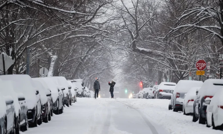
Winter weather has already made its presence felt this week, with cities from the Midwest to the Northeast seeing measurable snow and plummeting temperatures. In Connecticut, for example, a winter storm brought 2 to 4 inches of snow statewide, with some areas in the Northeast receiving even more and hazardous travel conditions reported throughout Sunday morning.
But as that cold air begins to drain out and upper-level winds shift, forecasters expect a significant warming trend over the next several days — a turnaround that will feel dramatic to many Americans.
The Warm-Up After the Snow
Across large swaths of the country, particularly the central and southern United States, temperatures are forecast to climb back to more seasonal — or even above-average — levels following this week’s winter systems. Forecasters indicate that winds aloft will usher in warmer air from the Pacific and Gulf regions, moderating conditions after the recent cold blast.
This type of temperature rebound is not unusual for December, especially when the jet stream shifts and allows milder Pacific winds to push inland. Historical patterns show that midwinter “warm spells” often follow bouts of Arctic-air outbreaks, and this week appears to fit that pattern, with highs expected to rebound out of the deep freeze in areas like the Midwest and Upper Plains early next week. National forecast maps from the National Weather Service reflect this warming transition as high-pressure builds across much of the lower 48 states.
Regional Highlights: Cold Now, But a Thaw Ahead
Northeast and Mid-Atlantic
Winter’s signature snow and bitter cold arrived early in parts of the Northeast, including New York City, which saw its first measurable snowfall of the season, with 1–3 inches expected in the five boroughs and up to 5 inches across surrounding suburbs and Long Island. After the snow tapers, temperatures are forecast to rise back into the 30s and 40s, signaling a break from truly frigid conditions.
Central United States
In the Midwest and parts of the Upper Plains, temperatures plunged into single digits and even subzero territory in recent days. In West-central Illinois, residents were warned of wind chills around -20°F as Arctic air poured in behind a recent storm system. However, models suggest that by midweek, highs will climb into the 30s and 40s — a welcome relief from the bitter cold.
South and Southeast
Even parts of the South felt winter’s bite, with an Arctic front dropping temperatures sharply in and around Houston, potentially bringing the area’s first winter freeze of the season. The cold will be brief, however, with forecasts showing a steady recovery into the 60s and even 70s by midweek, accompanied by low chances of rain.
Holiday Forecast: Warm or Snowy Christmas?
One of the biggest questions this season is whether the U.S. will see widespread white Christmas conditions. Early data and pattern analyses from seasonal outlooks — including long-range forecasts from entities like The Old Farmer’s Almanac — suggest that while some areas, especially in the northern Rockies and Appalachians, may see near-normal snow, much of the country will trend warmer and drier than typical for late December.
A warmer Christmas week has been hinted at in early forecasting guidance, where surface temperatures across large regions are expected to be above the long-term average for mid-December. That doesn’t rule out localized snow in colder pockets, but widespread accumulation across the Lower 48 seems less likely at this point.
What This Means for Travel and Safety
With both snow and cold still impacting travel — and holiday travel just around the corner — drivers and commuters need to stay alert. Snow and ice can linger on side roads even as daytime highs rise, leading to slick conditions. If temperatures rebound as expected, secondary freezing and refreeze events could occur overnight.
Transportation hubs have already felt the effects of winter weather in recent days, with snow and slush causing delays and cancellations across major airports. Conditions in the Northeast and Midwest remain dynamic, and travelers should continue to check real-time forecasts and advisories from the Federal Aviation Administration and local authorities.
Climate Context: Why This Winter’s Weather Is So Variable
Beyond the immediate storm and the incoming warm pattern, scientists remind us that this kind of weather whiplash — rapid swings between cold and warmth — is increasingly common. Large-scale climate patterns, including the potential transition from La Niña to neutral conditions in the Pacific, can influence storm tracks and temperature patterns across North America.
These broader climatic shifts don’t change daily weather, but they do help frame why the U.S. can see both Arctic blasts and mild stretches in relatively short order.
A Tasty Mix of Winter Weather Before Holiday Warmth
This winter week has already delivered classic seasonal weather: snow, cold, and icy conditions in many regions. But as the jet stream relaxes and warmer air builds in behind the storm systems, much of the country will enjoy a noticeable temperature rebound that could extend into Christmas week.
For now, the message from meteorologists is to stay prepared for both winter weather and warming trends — because December weather in the U.S. is rarely straightforward.
Stay tuned to updated forecasts from the National Weather Service and local stations as conditions continue to evolve across regions.