- High temperatures in the middle to upper 30s today
- Even warmer by Thursday
- Rain/snow likely Thursday
MADISON, Wis. (WMTV) – After a long run of below average temperatures, above average highs are expected over the next several days. High pressure will be in control for the morning hours today bringing in quite a bit of sunshine.
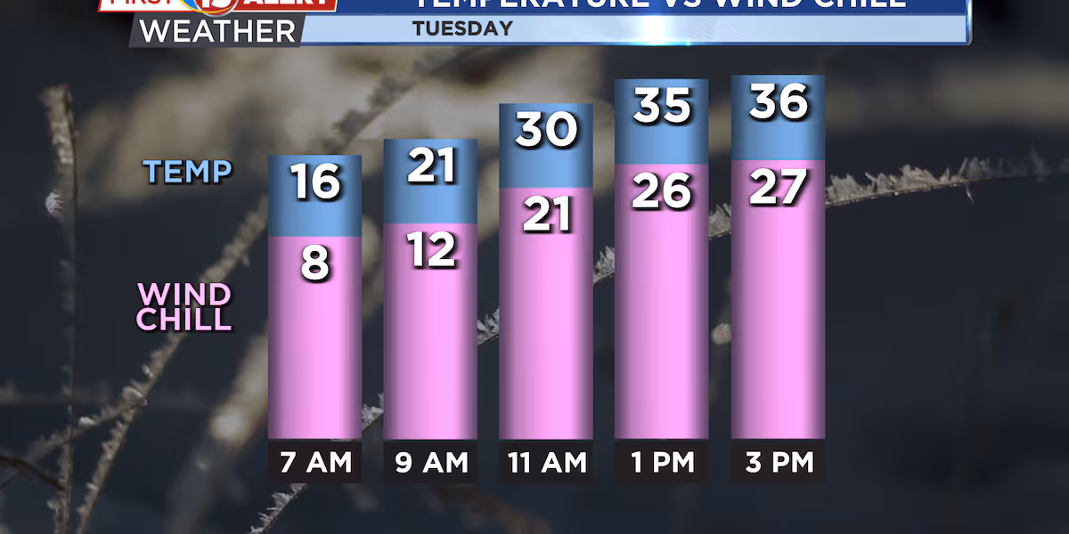
Mild temperatures but increasing wind expected for today. Wind chills will be in the 20s during the afternoon.(wmtv)
With southerly wind, temperatures will climb nicely. Highs this afternoon are expected to reach the middle to upper 30s.
As a warm front approaches from the west, clouds will increase through the afternoon and into the evening hours.
What’s Coming Up…
A mostly cloudy night is coming up, but it won’t be as cold as it has been. By tomorrow, we are back into sunshine. Under mostly sunny skies, our high temperatures will once again reach the middle, to upper 30s.
Later Wednesday night and into Thursday a wave of low pressure will move in. This will bring in even milder temperatures, but also the likelihood of rain late Wednesday night and into Thursday morning. By Thursday afternoon, cool enough air will fill in aloft and the rain will change to snow. Only minor accumulation of around 1/2 of an inch is expected Thursday afternoon.
Looking Ahead…
Cold air will then fill in behind the system for Friday. High temperatures will return to the 20s on Friday before moderating again on Saturday. Highs on Saturday will be back in 30s.
A cold front will move through pretty uneventfully Saturday night but temperatures will drop off again on Sunday and highs are anticipated back in the 20s. No precipitation is expected through the weekend.
Click here to download the WMTV15 News app or our WMTV15 First Alert weather app.
Copyright 2022 WMTV. All rights reserved.