Four of America’s most important rivers are showing what a warming, overdrawn future looks like right now. The Colorado River, San Rafael River, Mississippi River, and Rio Grande are drying up fast, squeezed by chronic drought, rising temperatures, and relentless human demand. Together, they supply water to tens of millions of people, irrigate some of the country’s most productive farmland, move billions of dollars in goods, and sustain fragile desert and wetland ecosystems.
Yet the warning signs are stark. The Colorado now rarely reaches the sea, and its great reservoirs sit at historic lows. The small but vital San Rafael drops into dry, broken segments where a continuous desert stream once flowed. The lower Mississippi swings between destructive floods and record-low levels that strand barges and invite saltwater inland, while the Rio Grande, long over-allocated, now fails to reach the Gulf for periods and even runs dry through major cities like Albuquerque.
1. Colorado River
Utah, The Colorado River and the dried up arm of Lake Powell at Hite, Utah
Once a mighty lifeline of the American Southwest, the Colorado River is rapidly drying up. Stretching 1,450 miles through seven U.S. states and two Mexican states, it historically supported ecosystems and 40 million people. But a combination of overuse, drought, climate change, and outdated water rights has caused the river’s decline.
Now, nearly its entire flow is diverted for agriculture, cities, and hydropower, and the lower 100 miles of the river have been almost entirely dry since the 1960s. Its once-rich delta in Mexico rarely sees water, with only trickles or artificial “pulse flows” reaching the sea. Massive reservoirs like Lake Mead and Lake Powell have dropped to record lows, threatening water supplies and power generation. Evaporation, population growth, and reduced snowpack from the Rocky Mountains have only worsened the crisis.
The Colorado is now among the most overallocated and litigated rivers in the world. In recent years, emergency water cuts and high-stakes negotiations have aimed to prevent catastrophic shortages.
2. San Rafael River
Wedge Overlook view of the San Rafael river canyon
The San Rafael River in east-central Utah, once a perennial desert stream carving spectacular gorges through the San Rafael Swell, is drying up fast. This 90-mile tributary of the Green River flows through one of the most scenic and remote regions of the Colorado Plateau, including the “Little Grand Canyon.” Historically fed by creeks in the Wasatch Plateau, the river has suffered from a combination of upstream water diversions, prolonged drought, and rising temperatures.
Irrigation tunnels divert water from the San Rafael’s headwaters to supply Sanpete County, reducing the river’s natural flow before it even descends into the desert. Over the past two decades, sustained drought has further depleted its volume, leading to extended dry stretches where fish and native riparian ecosystems once thrived. Scientists have observed sections of the river running completely dry in recent years, a stark contrast to its once-consistent seasonal flows.
The San Rafael River is now a symbol of growing water stress in the arid West. As Utah’s climate warms and water demand grows, this vital waterway faces an uncertain future.
3. Mississippi River
Drought in the Mississippi River
Though it remains one of the world’s largest rivers, the Mississippi is increasingly threatened by extreme drought and climate change, especially in its lower basin. In recent years, long stretches of the river have experienced record-low water levels, exposing sandbars, disrupting shipping routes, and straining municipal and agricultural water supplies. In 2022 and again in 2023, drought conditions caused major shipping delays, with over 2,000 barges stalled and water levels at Memphis and other key locations nearing historic lows.
The problem is partly due to reduced rainfall and snowpack in the vast Mississippi River Basin, which drains over 40% of the continental U.S. Sediment buildup and decades of river engineering, locks, levees, and dams, have also limited the river’s ability to naturally adjust to changing conditions.
To make matters worse, saltwater from the Gulf of Mexico is creeping upriver due to reduced freshwater flow, threatening drinking water systems in southern Louisiana. The Army Corps of Engineers has deployed underwater levees to block the intrusion temporarily, but these are stopgap measures.
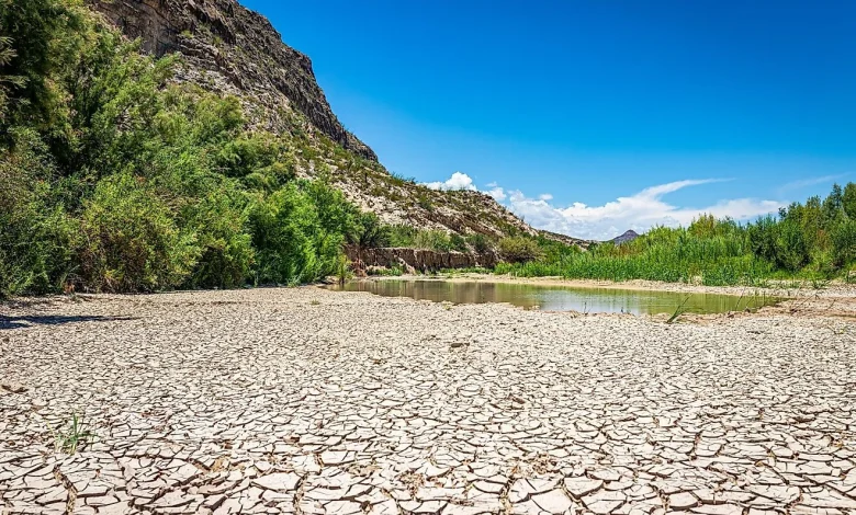
4. Rio Grande
Dried up Rio Grande river
The Rio Grande, stretching nearly 1,900 miles from Colorado to the Gulf of Mexico, is one of North America’s longest rivers, but today, large stretches of it are literally disappearing. Once a vital lifeline for agriculture, cities, and ecosystems across the American Southwest and northern Mexico, the river is now severely over-allocated and under threat from extreme drought and climate change.
Only about 20% of the Rio Grande’s original flow now reaches the Gulf. Massive diversions for irrigation and municipal use, especially around Albuquerque and El Paso, have reduced it to a trickle in many regions. In 2022, the river ran dry for five miles in Albuquerque, the first time in over 40 years, and again in 2023 after poor monsoon rains and record heat.
Reservoirs like Elephant Butte have plunged to critically low levels, dropping below 6% of capacity in late 2022. The Lower Rio Grande is now frequently dry near Presidio, Texas, and the water that does flow often comes from tributaries like the Rio Conchos.
These four rivers are more than regional stories; they are a preview of America’s water future. As climate change, overuse, and outdated policies drain them, communities face hard choices. Treating rivers as finite lifelines, not limitless resources, will decide whether they recover or simply become ghost channels on the map for millions.