Allard: New atmospheric river will make PNW ‘the wettest place in the world over the next six days’
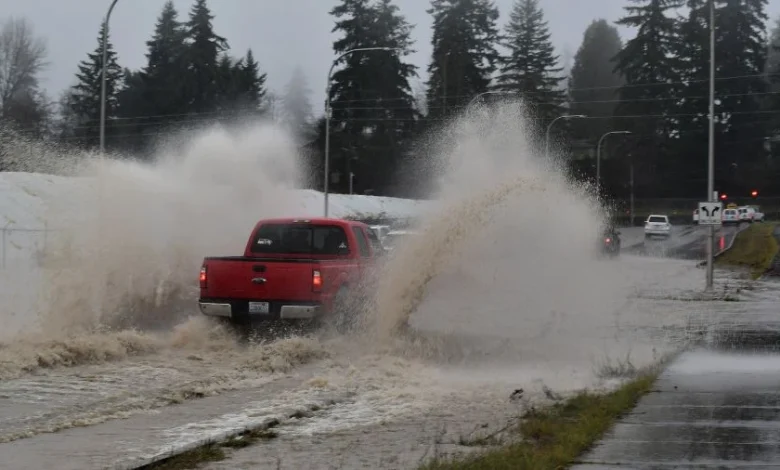
Western Washington barely had time to catch its breath. Another atmospheric river is slamming the Pacific Northwest today, and while flooding may not reach the historic levels seen last week, a KIRO 7 meteorologist said the overall impacts could actually be worse.
“This is going to be even more widespread and impactful if you ask me,” Nick Allard told “Seattle’s Morning News” on KIRO Newsradio Monday morning. “I mean, we had the flooding issues that were terrible. The flooding will not be as bad this time. But if you look at potential power outages, potential downed trees, and how much rain for days, and shutting down probably interstate travel because of the snow, I think if you look at days on end of this, it could be more impactful.”
Allard has declared Monday through Thursday an alert period, calling it “one of the more active weeks I can remember in a while across the area.”
Pacific Northwest one of the wettest places on Earth this week
Meteorologist Michael Snyder, who posts forecasts on X, put the situation in stark terms Saturday: “Outside of the Tropics, the Pacific NW is forecast to be the wettest place in the world over the next 6 days.”
Allard confirmed the scope of the system Monday morning. The atmospheric river currently drenching the region “stretches farther south and west than Hawaii does,” he said.
Seattle had already recorded nearly three-quarters of an inch of rain by early Monday morning. The lowlands can expect one to three inches through midweek, while the mountains could see three to seven inches of rain before snow finally arrives.
“The good thing about the rain today is it’s going to be a little more showery versus the steady rain we’ve had so far,” Allard said. “The problem is it will be heavy at times, so you’ll find some pockets of heavy showers, maybe an isolated thunderstorm or two.”
Wind advisories and watches through Wednesday
Wind may pose the biggest threat this week. A wind advisory remains in effect until 10 p.m. Monday, with gusts already reaching the mid-40s inland and 50-plus along the coast.
“I think gusts could be around 45 miles per hour or higher until this evening,” Allard said.
But the strongest winds are still coming. A high wind watch is in effect for western Washington starting Tuesday evening, with gusts potentially reaching 50-60 miles per hour late Tuesday night into Wednesday morning.
“Man, it’s going to be very windy tomorrow night and early Wednesday morning,” Allard said.
The combination of saturated soils from last week’s record rainfall and strong winds creates prime conditions for downed trees and power outages. Allard expects isolated outages throughout the week.
Snow finally coming to the mountains
After a week of warm temperatures that sent rain instead of snow into the Cascades, colder air is finally arriving. Snow levels will plummet from above 6,000 feet to between 2,000 and 2,500 feet by Wednesday morning.
“Then we’re looking at like one to three feet of snow for the mountain passes and higher through Thursday,” Allard said.
The shift to snow is good news for flood control, as it will lock moisture in the mountains rather than sending it rushing into rivers. But it also means treacherous pass travel for the foreseeable future.
“Travelers used to rainy pass travel need to be aware that winter weather conditions hit late Tuesday,” Allard’s forecast warned. “Snow will be heavy at times, and pass travel will be difficult.”
Rivers expected to rise again, but not reach record levels
The rivers that shattered records last week will rise again, though not to the same catastrophic levels. The Skagit River is expected to return to major flood stage at Concrete on Tuesday and at Mount Vernon by Tuesday night, with potential flooding issues continuing into Wednesday and Thursday.
The Snoqualmie, Snohomish, Skokomish, and Nisqually rivers are forecast to reach moderate flood stage between Tuesday and Wednesday. Minor flooding is likely on other rivers throughout the region.
Flooding from dam releases will persist on the Green and White rivers throughout the week. Officials continue to warn drivers never to drive around barricades, as road structures may have been damaged by last week’s flooding.
“River flooding will be an issue for much of the week,” Allard’s forecast stated. “We likely won’t start seeing rises on area rivers until late Monday night into Tuesday, as it takes some time for the heavy mountain rain to translate to the river systems.”
What to expect day by day
Monday: Showers with heavy pockets and possible isolated thunderstorms. Wind advisory in effect with gusts to 45 mph. Temperatures in the upper 50s to lower 60s. All rain in the mountains.
Tuesday: Rain continues, becoming heavy Tuesday night. High wind watch begins Tuesday evening with gusts potentially exceeding 50 to 60 mph. Rivers begin rising.
Wednesday: Rain turns to showers. Snow levels drop to 2,000 to 2,500 feet. Strong winds continue through the morning. Skagit River approaches major flood stage at Mount Vernon.
Thursday: Heavy mountain snow continues with one to three feet expected at pass level and above. Rivers begin to recede. Chilly rain showers in the lowlands.
By late week, the region should finally see rivers falling as snow continues piling up in the mountains. But the wet weather is not over. Chilly rain showers will persist into next weekend.
Charlie Harger is the host of on KIRO Newsradio. You can read more of his stories and commentaries . Follow Charlie and email him .
Follow @https://twitter.com/kirocharlie