KANSAS CITY, Mo. (KCTV) – It has been a quiet and seasonally warm week so far, but big changes arrive Thursday. A First Warn in place for a quick hit of light rain showers in the morning, strong winds gusting to 45-50 mph throughout the day and tanking temperatures in the evening.
Tonight will be cloudy and mild with temperatures hanging out in the low 50s to upper 40s. Thursday brings the First Warn for morning light rain, hours of strong winds and falling temperatures.
To get the latest weather updates sent to your phone, download the KCTV5 Weather app here.
Now let’s break down Thursday – starting with the chance for rain ahead of the front that kicks up the winds and drops temperatures.
Thursday morning brings a quick hit of light rain showers between 4 AM – 8 AM which is during the morning commute. Rain amounts look to be at a 0.1″ or less. Skies dry up and clear out quickly and that’s when strong winds take over for the rest of the day.
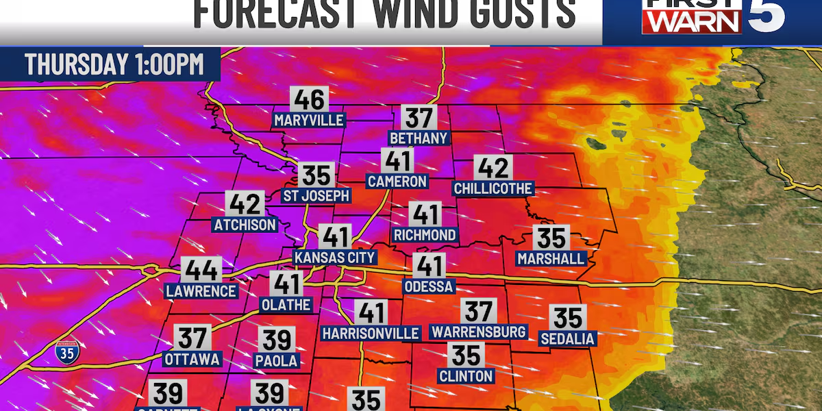
A Wind Advisory will go into effect at 8 AM and persist through 6 PM for sustained winds of 20 to 30 mph and gusts to 45 to 50 mph. With winds this strong – power outages will be possible, and any secured outdoor objects (holiday decor) may be knocked over or blown away. Please take the time to prepare for the winds ahead of Thursday. Winds gusts are expected to throttle back in the later evening but gusts to 30-35 mph remain possible.
What to Expect:
- Unsecured outdoor decorations may blow away
- Tree branches may snap
- Power outages are possible
- Driving conditions, especially for high-profile vehicles, could be hazardous
Thursday also poses a wild ride for temperatures. The high temperature will occur shortly after midnight on Wednesday night in the low 50s and drop to the mid 40s mid-morning Thursday. Once the rain clears out, we will have some sun before winds really kick up, which could allow temperatures to bounce back to the upper 40s around lunch.
The front drops through in the afternoon and will cause temperatures to tank into the 30s for the evening commute. Wind chill values will be as cold as the teens.
First Warn Thursday(KCTV)
We then see clear skies Thursday night into Friday morning, and low temperatures will bottom out around 20 but could feel like the single digits.
The good news is that Friday will be a calmer day. Partly cloudy skies are expected with highs in the mid 40s.
THIS WEEKEND: Partly cloudy skies with a nice December weekend ahead. Saturday will be the warmest day with highs in the low to mid 50s. Sunday stays pleasant with highs in the mid 40s which is still above average for mid-December.
CHRISTMAS WEEK: Get ready for one of the warmest Christmas weeks on record! High temperatures will range from 50 to 63 degrees. Christmas Eve is shaping up to be partly cloudy with highs around 57, and Christmas Day will reach the low 60s.
Christmas Week Warm Up(KCTV)
Copyright 2025 KCTV. All rights reserved.