N.J. weather: Dangerous wind gusts up to 60 mph, pounding rain in turbulent forecast for today
Fierce wind gusts and heavy downpours are already hitting New Jersey on Friday morning, but some of the worst weather from a nasty storm is still to come, forecasters say.
Thousands of homes and businesses were already without power early Friday.
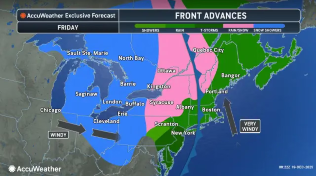
A powerful cold front could crank wind gusts up to 60 mph with some rainfall totals of 1.5 inches, according to the National Weather Service.
A wind advisory in effect for all 21 counties until 1 a.m. Saturday.
“Rain and gusty winds will continue across the region for much of Friday morning,” the weather service said.
The weather service has issued a marginal severe weather risk, warning that saturated ground from recent snowmelt could make trees more susceptible to falling.
A powerful cold front blasting the state Friday could include wind gusts up to 60 mph and up to 2 inches of rain in some spots. The worst weather is expected during the morning commute.AccuWeather.com and National Weather Service
The cold front is expected to enter New Jersey by 7 a.m. Friday and move offshore by noon.
As the front approaches between 8 and 11 a.m., a line of storms will push through the state, bringing the greatest threat of damaging winds from strong downdrafts.
“This will be the period to watch for damaging wind gusts upwards of 60 mph,” the weather service said early Friday.
A powerful cold front blasting the state Friday could include wind gusts up to 60 mph and up to 2 inches of rain in some spots. The worst weather is expected during the morning commute.AccuWeather.com and National Weather Service
Rainfall totals will hover around 1 inch statewide with some areas potentially getting up to 2 inches.
The heaviest rain is expected during the morning commute. While flash flooding is not expected, minor flooding in urban and poor drainage areas is likely.
Winds were already gusting to 40 mph early Friday and will continue through the morning hours.
After the front passes at midday, winds will ramp back up during the afternoon and evening, with sustained winds of 20 to 30 mph and gusts of 35 to 45 mph, potentially reaching 50 mph.
These strong winds will persist from early afternoon until late evening before gradually diminishing overnight.
Temperatures Friday morning will climb into the 50s and low 60s ahead of the front, approaching the record highs for Dec. 19 at Newark airport of 60 degrees set in 1931.
Once the front passes, temperatures will drop throughout the afternoon, falling into the upper 30s and low 40s by sunset.
Overnight lows will plunge into the low to mid 20s, and any standing water on surfaces may freeze.
Saturday will bring quiet, dry weather as high pressure builds in, though temperatures will remain below normal with highs in the upper 30s in northwestern New Jersey and low to mid 40s elsewhere.
Sunday will see another cold front pass through, bringing gusty winds but no precipitation.
Temperatures will climb slightly above normal Sunday, with highs ranging from the low 40s in northwestern areas to near 50 degrees in southeastern New Jersey.
The extended forecast shows high pressure dominating Monday with frigid conditions and highs only in the low 30s.
Tuesday brings increased chances of precipitation as a frontal system moves through, with a 40 to 50% chance of rain or snow.
Temperatures will moderate through the week, returning to near-normal readings by Wednesday and climbing above normal for Christmas Day.
AccuWeather’s updated white Christmas forecast holds a chance for snow on the holiday for the northeastern U.S.AccuWeather.com