PORTLAND, Ore. (KATU) — Residents across Oregon and western Washington will see the winds pick up tonight and early Wednesday as the next incoming weather maker arrives.
WEATHER | Latest Storm Tracker 2 Forecast
“Right now, there is a low-end threat for higher wind gusts also impacting area residents across the entire Willamette Valley,” said Storm Tracker 2 Meteorologist Rhonda Shelby.
The Storm Prediction Center in Norman, Oklahoma, has placed most of the Pacific Northwest under a “Marginal” risk for severe weather due to the anticipated winds.
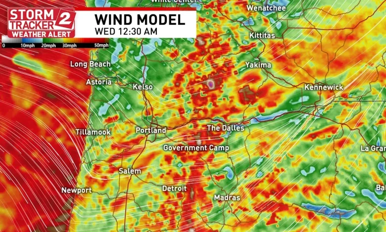
Forecast models show a line of strong storms forming and moving through the region tonight.
“Sporadic lightning flashes and occasional strong to severe-caliber wind gusts may accompany the passage of this low-topped convective line, with the most intense low-level winds/convective influences expected to peak during the overnight and early morning hours Wednesday,” the Storm Prediction Center said in their afternoon outlook. “However, it remains quite uncertain if these convectively enhanced winds will be substantially stronger than the background gradient wind field.”
SPC says there is a 5% chance of seeing damaging thunderstorm winds or wind gusts of 57 mph or higher within 25 miles of the shaded area on the map below.
Severe Wind Threat – Any area within the brown shading could see damaging winds or a wind gust of at least 57 mph within a 25 mile range of any point – Storm Prediction Center Map – Storm Tracker 2 Weather graphic
Even if the winds don’t reach severe criteria, winds will be extremely strong across the region tonight.
The timing of the highest winds arriving on the Oregon Coast between 10 p.m. and midnight, and into the Willamette Valley between 11 p.m. and 1 a.m. With already saturated soils from previous atmospheric rivers, winds could bring trees down in some areas.
“It will be mostly higher elevations, coastal cities, and residents in the Columbia Basin have the highest chance damaging wind gusts or power outages,” Shelby added. “This is the time of year to be Storm Ready…anywhere in Oregon. On average, our area sees more windstorms in the winter months.”
The National Weather Service in Portland has issued a High Wind Warning for the Oregon Coast, while the Coast Range, Cascade foothills, and Willapa Hills are under a Wind Advisory. Both the advisory and warning go into effect at 4 p.m.
In addition to the wind, forecast models are calling for about an inch of rain to fall between this evening and tomorrow at 5 p.m.
Rainfall totals through Wednesday afternoon – Storm Tracker 2 Weather graphic
We get a brief respite from the rain and wind on Wednesday before a stronger atmospheric river moves into the region. The next blast of rain and wind will arrive Thursday morning.
NWS Portland has issued a Flood Watch that remains in effect from late Wednesday night through late Friday night.