If you’ve felt a persistent draft and heard the howling wind since Halloween, you’re not imagining things – that’s the sound of an impatient November. Forget slowly easing into winter; we are attempting to cram the entire fall-to-winter identity swap as Sunday turns to Monday. Grab your heavy coat, because the seasons are clearly in a hurry as we are tracking the area’s first snowflakes of the season arriving.
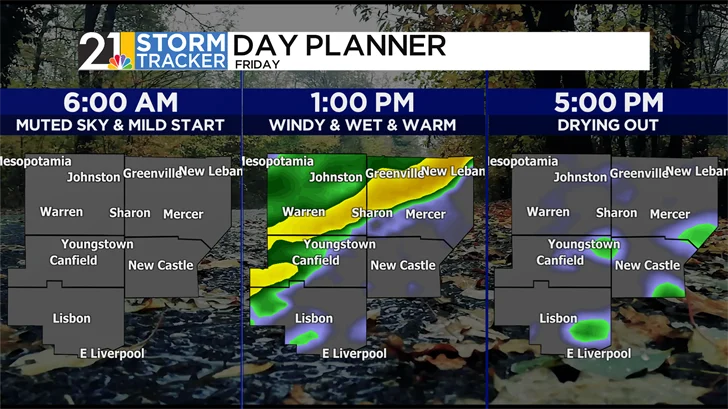
But first, we have a little business to take care of, including a temporary surge of above-average warmth today on a gusty wind out ahead of the arrival of a swift cold front. We’re getting a slice of early filtered sun before the thicker clouds move in and raindrops chase our dry time away.
Our temperatures are bumping into the mid-50s. Around lunchtime, showers work from northwest to southeast. If you have plans, prepare for a wet afternoon, commute home from work and school, and have your rain gear ready for the stadium stands for at least playoff football kickoff time. We are expecting a mainly dry Friday evening – can we hear a little commotion for those pivotal football games – for all your plans!
After Friday’s brief, gusty warm-up, we’re hitting the brakes and getting back to November reality. Saturday will be relatively quiet, but also decidedly cooler – think upper 40s to around 50-degrees at best. And while the day is mostly cooperative, don’t forget the poncho for the YSU afternoon game. With those lingering clouds, a few rogue sprinkles still can’t be ruled out. Basically, it’s a good day for cozy knits and getting the leaves picked up as the winds relax!
Alright, enough with the quiet weekend – it’s time for the main event. We now turn our attention to the well-advertised storm system arriving Sunday. The drama starts in the morning, thanks to an invading Arctic front. That boundary will be the pivot point, changing daytime rain to snowflakes through the overnight.
Our latest update shows the rain arriving in the morning and perhaps lingering into the afternoon, accompanied by some gusty winds. But the forecast has an extra layer of uncomfortable: temperatures will begin to tumble late with those showers and winds, meaning the afternoon and evening hours are going to be noticeably chilly.
Say goodbye to fall and hello to the deep freeze. As we transition on Sunday evening, rain will surrender to a mix, giving way to mainly flurries and/or snow showers by Monday morning.
Monday is going to be brutal: snow showers, plus lake-effect snow, all while the wind howls. With highs only hitting the mid-30s and wind chills making it feel like the teens, this is a sharply different, December-like shock to the system. You’ll need every layer you own!
While the main storm clears, the fun isn’t quite over. Lake effect snow will be setting its sights squarely on you Monday night into Tuesday before finally clearing out. Accumulations will be possible – especially those in the primary snowbelt.
The cold air rotates aggressively into Tuesday, making that morning commute the coldest part of the entire week. But take heart! This Arctic visit is short-lived. We’ll finally begin to moderate our temperatures right after that, proving this severe taste of winter was just a quick, but memorable, few days.
Have a great Friday!
Here’s a look at your 7-day morning forecast: