HOUSTON – Elevated to critical fire weather conditions are expected for today and Monday, even some into Tuesday due to gusty northerly winds and drier air in the wake of the cold front.
Fire concerns
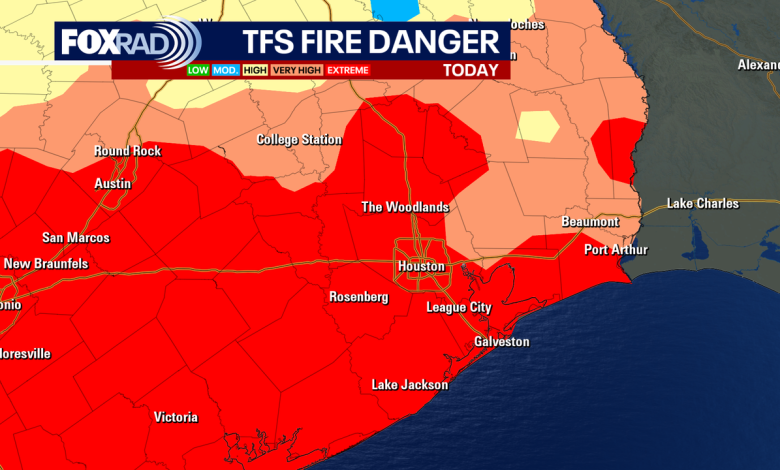
A Red Flag Warning is in effect Sunday for all of Southeast Texas. The National Weather Service has since extended the warning until 6 p.m. Monday.
If a fire forms, it will likely spread very quickly. Outdoor fires are not recommended. Burn Bans are still persistent across the state.
Sunday Cold Front
Following the cold front, a strong breeze will usher in a sharp drop in temperatures, highs in the low 70s, and humidity values. Winds will come from the north and could gust to 30 mph.
Due to low humidity, gusty winds and our worsening drought, fire conditions will be critical on Sunday and into Monday, so be very careful not to spark anything outdoors.
Starting tonight and into Monday, the air turns much cooler. Overnight lows will dip into the low 40s with mid-upper 30s north of Houston both Monday morning and Tuesday morning. Feels like temps or wind chills will likely be in the 20s and 30s Monday morning, so make sure the kids are bundled up at the bus stop. We haven’t seen temperatures this low since February! Frost is a possibility on the ground on those chilly mornings. Continuing the temperature swings, we’ll be back in the 80s by mid to late next week.
Tropical Weather Update
Tropical cyclone activity is not expected in the Atlantic Basin during the next 7 days. Any chance for additional tropical activity for the Gulf for the rest of this month is extremely low. Overall activity is winding down as the season gets closer to ending.
The Source: Information in this article is from the FOX 26 Houston weather team.
WeatherHouston