Maryland will experience winter-like weather and gusty winds, prompting First Alert Weather Days on Monday and Tuesday.
An Arctic blast is bringing a one-two punch of cold to Maryland.
On Monday morning, wind-chills dipped into the lower to middle 30s across the Baltimore metro region. The First Alert Weather Team is forecasting an even colder morning to begin Veterans’ Day.
Winter-like weather in Maryland
A Winter Weather Advisory is in effect for western Garrett County, in far western Maryland. Accumulating snow is forecast to fall in the higher elevations of western Maryland through Tuesday morning. 3″ to 6″ of snow will fall in western Garrett County before snow showers diminish.
While snow showers are likely across the far western mountains of western Maryland, the chance for snow flurries in and around Baltimore appears quite low. A reinforcing shot of arctic air that arrives Monday evening will spawn snow flurries to our south. An additional disturbance that arrives Tuesday afternoon and evening will spawn snow flurries to our north. Central Maryland appears to be in a less favorable area for flurries, but given the cold setup, one or two snowflakes cannot be ruled out.
Monday night and Tuesday, we will feel the second – and strongest – punch of cold. Actual temperatures will fall into the middle to upper 20s by early Tuesday morning. Wind gusts increase early Tuesday and may gust as high as 40 mph. Once you combine the cold air with gusty northwest winds, wind-chills will bottom out in the upper teens and lower 20s, making for a bitterly cold Tuesday morning commute.
In addition to the numbing wind-chills, strong wind gusts out of the west will create intense cross winds on some area bridges, which may cause wind warnings and restrictions Monday night through Tuesday.
Tuesday afternoon stays very cold with winds howling out of the west at 20 to 30 mph with gusts to 40 mph still possible. Despite a mix of clouds and sunshine, wind-chills will only peak in the low to mid-30s. Tuesday is a day where you will want to wear all of the layers of hats, gloves, scarves, and a heavier winter jacket. Please also bring your pets inside during this stretch of cold weather..
Mild weather returns by mid-week
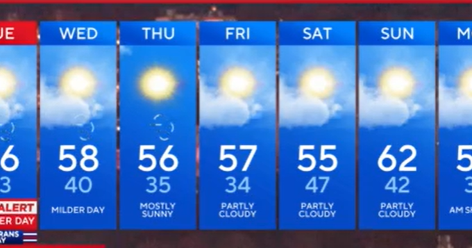
Wednesday morning will start off cold with early morning temperatures starting in the 20s and 30s. Abundant sunshine along a gusty southwest wind will usher in milder air.
Wednesday afternoon temperatures will likely peak in the upper 50s to lower 60s.
Temperatures still stay close to their seasonal averages (upper 50s for highs, 30s for lows) through the end of the week into next weekend. This is a very dry pattern with little to no rain in the forecast. Even milder air may try to sneak in by next Sunday as a warm front lifts to our north of our area. Highs could top out in the upper 50s to lower 60s with gusty west to southwest winds.