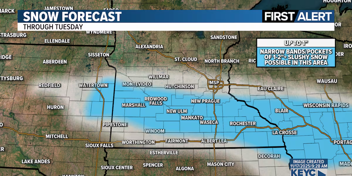
We are tracking a fast moving system that will bring rain and snow to much of our region later today tonight into Tuesday morning. Liquid precip amounts of a half inch or more are possible, and slushy snowfall accumulation of 1 to 2+ inches is also possible. Some of our models suggest a few very localized spots could pick up even more. As of right now, the best chance for slushy snow looks to be north of I-90 and south of US Hwy 212. While some places may pick up an inch or two of accumulation others will get mostly rain with almost no snow at all. Everything will depend on temperature which could fluctuate depending on where you are. As of right now, plan on at least a little snow and some slippery roads late tonight through the Tuesday morning commute.
Rain will continue to develop and move into the region this evening and overnight tonight. As temperatures cool into the low to mid 30s rain will mix with snow, and in some spots may even transition to all snow. Ground temperatures are still quite warm so a lot of the snow will melt but some locations could still pick up an inch or two of wet slushy snow. Light rain and snow will continue into Tuesday morning but will end by mid to late morning. The rest of Tuesday will stay mostly cloudy with highs only reaching the upper 30s to near 40 degrees.
The rest of the week will be relatively low key. Wednesday and Thursday will be partly cloudy and warmer than average with highs in the upper 40s Wednesday and low 50s Thursday. We have been watching a system that will move across the central US late this week but as of right now I think that system will stay mainly to our south. While I do have a slight chance of rain in the forecast for northern Iowa late this week it’s looking increasingly likely the system will stay along and south of I-80. Stay tuned for updates.
Long range models that take us into the Thanksgiving holiday weekend remain relatively low key. While we are still well over a week away I’m not terribly concerned about anything major at this point. Of course, that can always change this far out. I’ll let you know if it does.
1 to 2 inches of slushy snow accumulation is possible across parts of southern Minnesota Monday night into Tuesday.(KEYC Weather)One-half inch or more is possible with a system that will move through Monday night into Tuesday morning.(KEYC Weather)
KEYC First Alert 10 Day Forecast
KEYC First Alert 10 Day Forecast
KEYC First Alert 10 Day Forecast: This image updates in real time as the forecast changes.
Planner Forecast
KEYC First Alert Planner Forecast: This image updates in real time as the forecast changes.
Click here to download the KEYC News Now app or our KEYC First Alert weather app.
Copyright 2025 KEYC. All rights reserved.