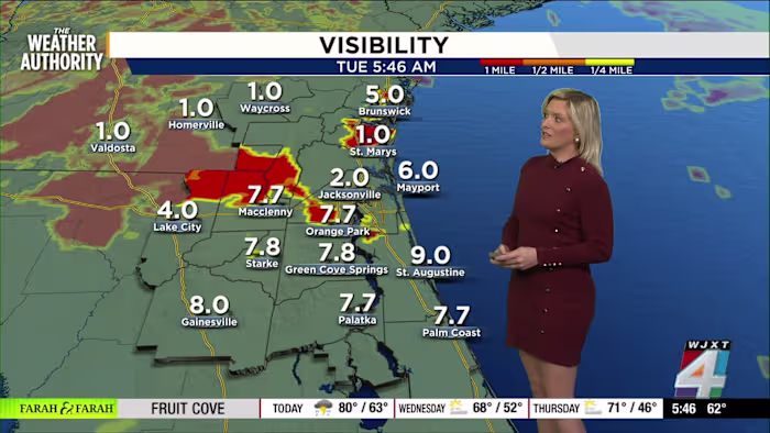
JACKSONVILLE, Fla. – It’s a gray start across Jacksonville this morning, and if you’re heading out, I want you to be extra careful.
We’re seeing dense fog in a lot of spots—at the airport, on the Southbank, and around the city. As of this morning, visibility in Jacksonville has dropped to about two miles, and it’s even lower in a few surrounding areas.
Give yourself some extra time on the roads. Make sure those headlights are on low beam, and keep an eye out for kids going to school.
Some places, like Gainesville, have actually improved a bit, but fog is still patchy and unpredictable. If you have travel plans soon, check traffic updates before you leave.
Rain and storms end the dry streak
Here’s some good news: rain is finally back in the forecast after a bone-dry November. In fact, Jacksonville didn’t see a single drop last month—something that’s never happened before!
Showers are rolling in from the Gulf and moving across our region this morning, with a 60% chance you’ll see rain or even a thunderstorm during the day. If you hear some rumbles, don’t be surprised. Most storms look to remain below severe limits, but a “marginal” risk means gusty winds are still possible in some spots.
Our Exact Track 4D radar is lighting up with scattered showers—you might get missed, but the cells that do develop could pack a punch. And it’s not just today; another weather system is aiming for us again by Friday, which brings another round of much-needed rain just in time for the weekend.
If being outside on rainy days isn’t your thing, this might be a good excuse for some indoor plans. And if your plans include dog walking, don’t forget a raincoat—for both of you!
Cooler temperatures, changing conditions
Temperature-wise, we’re starting off in the low 60s this morning, with highs near 78 degrees before the next front pushes through. After that, you’ll notice things cool off sharply—down to the 60s for highs and even 40s for overnight lows by midweek.
This chilly spell won’t last too long, though; we’re expected to rebound to near-average temps by Friday and Saturday, staying within a couple degrees of the usual 70-degree high.
One thing that will stick around: the muggy feeling in the air should hang on through Friday, thanks to all this unsettled weather. After that, drier air moves in for a short while.
If you’re thinking about heading to the beach, keep in mind there’s a moderate rip current risk. Even if the sun peeks out, it’s still not the best day for a swim.
Wherever you are in the Jacksonville area, let your neighbors and The Weather Authority team know what the sky looks like for you. Snap and share your weather photos anytime at SnapJAX.
Copyright 2025 by WJXT News4JAX – All rights reserved.